Totland Bay
Encyclopedia


Isle of Wight
The Isle of Wight is a county and the largest island of England, located in the English Channel, on average about 2–4 miles off the south coast of the county of Hampshire, separated from the mainland by a strait called the Solent...
, England
England
England is a country that is part of the United Kingdom. It shares land borders with Scotland to the north and Wales to the west; the Irish Sea is to the north west, the Celtic Sea to the south west, with the North Sea to the east and the English Channel to the south separating it from continental...
. It lies to the west of the village of Totland
Totland
Totland is a village and civil parish at the western tip of the Isle of Wight. It lies on the coast at Colwell Bay, which is the closest part of the island to the British mainland...
from which it takes its name. It faces north west and its shoreline is 4km in length and is made up of a straight west facing coast which has a beach, concrete seawall
Seawall
A seawall is a form of coastal defence constructed where the sea, and associated coastal processes, impact directly upon the landforms of the coast. The purpose of a seawall is to protect areas of human habitation, conservation and leisure activities from the action of tides and waves...
, groynes and pier and a straight north facing rocky coastline. It stretches from Warden Point in the north to Hatherwood Point in the south west.
The seabed is a mixture of mud and sand. The beach is predominantly shingle
Shingle beach
A shingle beach is a beach which is armoured with pebbles or small- to medium-sized cobbles. Typically, the stone composition may grade from characteristic sizes ranging from two to 200 mm diameter....
. Since 2001 the quality of the beach has been high enough for it to be awarded the Seaside Award Flag. Throughout the Summer season the beach is litter-picked and seaweed removed for use as compost to local farmers.
At one end of the bay is a lifeboat station. This was built from money raised by local Sunday School children in 1870. By 1915 the Totland Lifeboat Station was equipped with the island's first steam lifeboat. The lifeboat station closed in 1924 although its remains still exist today.
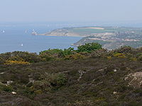
The bay is best viewed from Headon Warren or anywhere along the concrete seawall. The Isle of Wight Coastal Path
Isle of Wight Coastal Path
.There are a couple of cafes on the cliff path which I believe are open in the summer months. The only public convenience on the cliff path now appears to be closed permanently ....
runs along the seawall from Warden Point to Widdick Chine
Widdick Chine
Widdick Chine is a geological feature on the west coast of the Isle of Wight, England. It is west of the village of Totland.It is a steep coastal gully, which is overgrown with vegetation. The water that used to flow down the slope has been redirected through a pipe which takes it to beach level to...
.
Pier
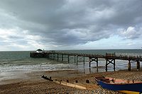
The pier at Totland Bay was built and opened in 1880. It was commissioned by Totland Bay Hotel and designed by S.H and S.W Yockney measuring 450 feet. The pier was constructed of a light girder framework on cast iron piles with a timber deck. The principal reason behind its construction was to encourage tourists to the area by providing a safe and convenient steamer landing stage. At the time of construction, facilities were limited to a small wooden shelter at the head and a small amusement pavilion at the shore-wood end. Initially, the pier only received a small number of steamer excursions from LymingtonLymington
Lymington is a port on the west bank of the Lymington River on the Solent, in the New Forest district of Hampshire, England. It is to the east of the South East Dorset conurbation, and faces Yarmouth on the Isle of Wight which is connected to it by a car ferry, operated by Wightlink. The town...
and Yarmouth
Yarmouth, Isle of Wight
Yarmouth is a port and civil parish in the western part of the Isle of Wight, off the southern coast of mainland England. The town is named for its location at the mouth of the small Western Yar river...
, however this later extended to include trips around the island and to mainland destinations like Bournemouth
Bournemouth
Bournemouth is a large coastal resort town in the ceremonial county of Dorset, England. According to the 2001 Census the town has a population of 163,444, making it the largest settlement in Dorset. It is also the largest settlement between Southampton and Plymouth...
, Southampton
Southampton
Southampton is the largest city in the county of Hampshire on the south coast of England, and is situated south-west of London and north-west of Portsmouth. Southampton is a major port and the closest city to the New Forest...
and Portsmouth
Portsmouth
Portsmouth is the second largest city in the ceremonial county of Hampshire on the south coast of England. Portsmouth is notable for being the United Kingdom's only island city; it is located mainly on Portsea Island...
. Today the pier is no longer open to the public. There is a small cafe at the start, and the shelter is still in place at the pier head, in private ownership and used as an art gallery.

