

Toquima Range
Encyclopedia
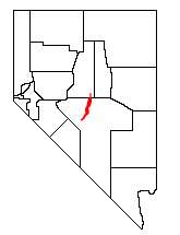
The Toquima Range is a line of mountains in northwestern Nye County
Nye County, Nevada
-National protected areas:* Ash Meadows National Wildlife Refuge* Death Valley National Park * Humboldt-Toiyabe National Forest * Spring Mountains National Recreation Area -Demographics:...
, in central Nevada
Nevada
Nevada is a state in the western, mountain west, and southwestern regions of the United States. With an area of and a population of about 2.7 million, it is the 7th-largest and 35th-most populous state. Over two-thirds of Nevada's people live in the Las Vegas metropolitan area, which contains its...
in the western United States
United States
The United States of America is a federal constitutional republic comprising fifty states and a federal district...
. From Hickson Summit on U.S. Route 50, the range runs for approximately 71 miles (115 km) to the south-southwest. To its west are Big Smoky Valley
Big Smoky Valley
The Big Smoky Valley is a landform of the Tonopah Basin between the Toiyabe and Toquima mountain ranges. It is about 100 miles in length, and is known by other names : including Great Smoky Valley, Smokey Valley, Smoky Valley, Wen-A-No-Nu-Fee Valley, and Won-A-No-Nu-Fee Valley. The U.S...
, scenic State Route 376
Nevada State Route 376
State Route 376 is a state highway in central Nevada in the United States. It connects U.S. Route 6 near Tonopah north to U.S. Route 50 near Austin...
, and the large Toiyabe Range
Toiyabe Range
The Toiyabe Range is a range of mountains in central Nevada in the western United States. It starts in northwestern Nye County north of Tonopah, Nevada and runs approximately 120 miles north-northeast through eastern Lander County, making it the second longest range in the state...
. To the east are remote Monitor Valley and the Monitor Range
Monitor Range
The Monitor Range is located in south-central Nevada in the United States. The range lies west and northwest of the Hot Creek Range and north of Highway 6 in Nye County, and extends for approximately 106 miles into Eureka County at its northern end.The Forest Service is in charge of 83.6% of the...
. Lying to the south of the range are U.S. Route 6 (Nevada) and the community of Tonopah
Tonopah, Nevada
Tonopah is a census-designated place located in and the county seat of Nye County, Nevada. It is located at the junction of U.S. Routes 6 and 95 approximately mid-way between Las Vegas and Reno....
, while to the north is U.S. Route 50 ("The Loneliest Highway in America"), leading to the small community of Austin
Austin, Nevada
Austin is a small, unincorporated community located in Lander County, Nevada, in the United States. As of 2004, its population is approximately 340. It is located on the western slopes of the Toiyabe Range at an elevation of . U.S...
.
Tundra
In physical geography, tundra is a biome where the tree growth is hindered by low temperatures and short growing seasons. The term tundra comes through Russian тундра from the Kildin Sami word tūndâr "uplands," "treeless mountain tract." There are three types of tundra: Arctic tundra, alpine...
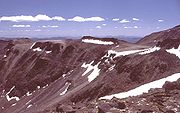
. Three summits here comprise Mt. Jefferson, the highest points in the range (and in all of central Nevada). The southern summit rises to an elevation of 11,941 feet (3639 m). This section of the range is protected as the Alta Toquima Wilderness Area
Alta Toquima Wilderness
The Alta Toquima Wilderness is a protected wilderness area in the Toquima Range of Nye County, in the central section of the state of Nevada in the western United States. It covers an area of ,...
.
South of this area are the historic mining district of Manhattan
Manhattan, Nevada
Manhattan is a small town in Nye County, Nevada located on State Route 377 about 50 miles north of Tonopah, the county seat, off State Route 376....
, Spanish Peak (10,746 ft, 3275 m), and Shoshone Mountain
Shoshone Mountain
also located in Nye County.Shoshone Mountain is a mountain range in Nye County, Nevada....
(10,907 ft, 3324 m). To the north are Wildcat Peak (10,507 ft, 3202 m) and White Rock Mountain (10,156 ft, 3095 m).