
Thouet
Encyclopedia
The Thouet is a tributary
river
of the Loire
in the Poitou-Charentes
and Pays de la Loire
régions
of France
. The Thouet rises at Secondigny
, close to the source of the Sèvre Nantaise
, and joins the Loire just to the west of Saumur
. It is 142 km (88.2 mi) long, and drains an area of 3396 km² (1,311.2 sq mi).
The river's name derives from the ancient Gallic
word for tranquil.
.jpg)
 The Thouet rises in the Gâtine Vendéenne
, the most southern outcrop of the Massif Armoricain, at 225 metres altitude. The Massif armoricain is made up of volcanic
and metamorphic
rocks dating back to the Paleozoic era
. This impermeable land does not result in any important aquifer
s but is an area of significant rainfall runoff. From the source to Parthenay
the river flows in a generally east-west direction.
To the east of Parthenay, the river turns north and flows on a generally northward heading for the rest of its course. Between Saint-Loup-Lamairé
and Thouars
, the river flows onto the Paris Basin
, an area of sedimentary rock
s where successive marine deposits of periods from the Triassic
to the Pliocene
were laid down. The nature of the rocks here allows the formation of an aquifer whose water reserves support the river in times of low flow.
In order downstream, the Thouet flows through:
The principal tributaries
of the River Thouet are:
For much of its length, the Thouet is paralleled by the GR 36
long-distance walking route
, which connects Ouistreham
, on the coast of the English Channel
, with Bourg-Madame
, on the border with Spain
. This stretch of the path traces the footsteps of pilgrims
from Brittany
and Normandy
on their way to Santiago de Compostela
, and in places crosses the river using the same ford
s, packhorse bridge
s and stepping stone
s the pilgrims would have used.
. It is possible that boats were already carrying goods on the river before that date, the cargo being transferred between boats at each obstacle.
King Charles VII
authorised the start of work by letters patent
, financing the work by allowing the lords of Montreuil-Bellay to raise a tax on wine that would pass through their land. In the 15th and 16th centuries, the passage through the weirs probably took the form of flash lock
s. The later pound lock may have been introduced towards the end of the 16th century, and it is known that three pound locks were in use on the river by 1608. A project to make the river navigable up to Thouars was proposed in 1746 but was never executed.
The River Dive, a tributary of the Thouet, was canalised in 1834 to create the Canal de la Dive. As part of this development, two modern pound locks with straight sides and mitred gates were built on the Thouet, downstream of the confluence with the Dive. A third modern lock was built at the same time on the Thouet, but upstream from the confluence of the Dive. These locks had dimensions of 32 m (105 ft) length, 5.2 m (17.1 ft) width, and a draught of 1.6 m (5.2 ft).
However the new navigation soon faced competition from better roads and the railway, which appeared in the region in 1874. The maximum boat size imposed by the locks proved insufficient, and a proposed enlargement to the larger Freycinet gauge
was never realized. The last commercial navigation on the river was in 1920.
Tributary
A tributary or affluent is a stream or river that flows into a main stem river or a lake. A tributary does not flow directly into a sea or ocean...
river
River
A river is a natural watercourse, usually freshwater, flowing towards an ocean, a lake, a sea, or another river. In a few cases, a river simply flows into the ground or dries up completely before reaching another body of water. Small rivers may also be called by several other names, including...
of the Loire
Loire (river)
The Loire is the longest river in France. With a length of , it drains an area of , which represents more than a fifth of France's land area. It is the 170th longest river in the world...
in the Poitou-Charentes
Poitou-Charentes
Poitou-Charentes is an administrative region in central western France comprising four departments: Charente, Charente-Maritime, Deux-Sèvres and Vienne. The regional capital is Poitiers.-Politics:The regional council is composed of 56 members...
and Pays de la Loire
Pays de la Loire
Pays de la Loire is one of the 27 regions of France. It is one of the regions created in the late 20th century to serve as a zone of influence for its capital, Nantes, one of a handful so-called "balancing metropolises" ¹...
régions
Régions of France
France is divided into 27 administrative regions , 22 of which are in Metropolitan France, and five of which are overseas. Corsica is a territorial collectivity , but is considered a region in mainstream usage, and is even shown as such on the INSEE website...
of France
France
The French Republic , The French Republic , The French Republic , (commonly known as France , is a unitary semi-presidential republic in Western Europe with several overseas territories and islands located on other continents and in the Indian, Pacific, and Atlantic oceans. Metropolitan France...
. The Thouet rises at Secondigny
Secondigny
Secondigny is a commune in the Deux-Sèvres department in western France.It is situated about 14 km west of the town of Parthenay and 35 km north of Niort....
, close to the source of the Sèvre Nantaise
Sèvre Nantaise
The Sèvre Nantaise is a river in western France, left tributary to the river Loire. Its source is in the Deux-Sèvres département, near Secondigny.It flows through the following départements and towns:*Deux-Sèvres: Moncoutant, La Forêt-sur-Sèvre...
, and joins the Loire just to the west of Saumur
Saumur
Saumur is a commune in the Maine-et-Loire department in western France.The historic town is located between the Loire and Thouet rivers, and is surrounded by the vineyards of Saumur itself, Chinon, Bourgueil, Coteaux du Layon, etc...
. It is 142 km (88.2 mi) long, and drains an area of 3396 km² (1,311.2 sq mi).
The river's name derives from the ancient Gallic
Gaulish language
The Gaulish language is an extinct Celtic language that was spoken by the Gauls, a people who inhabited the region known as Gaul from the Iron Age through the Roman period...
word for tranquil.
Course of the river
Gâtine vendéenne
The Gâtine Vendéenne is a historical area in the west of France, around the town of Parthenay in the département of Deux-Sèvres. The area is hilly and wooded, distinguished by small fields and relatively poor land....
, the most southern outcrop of the Massif Armoricain, at 225 metres altitude. The Massif armoricain is made up of volcanic
Volcanic rock
Volcanic rock is a rock formed from magma erupted from a volcano. In other words, it is an igneous rock of volcanic origin...
and metamorphic
Metamorphic rock
Metamorphic rock is the transformation of an existing rock type, the protolith, in a process called metamorphism, which means "change in form". The protolith is subjected to heat and pressure causing profound physical and/or chemical change...
rocks dating back to the Paleozoic era
Paleozoic
The Paleozoic era is the earliest of three geologic eras of the Phanerozoic eon, spanning from roughly...
. This impermeable land does not result in any important aquifer
Aquifer
An aquifer is a wet underground layer of water-bearing permeable rock or unconsolidated materials from which groundwater can be usefully extracted using a water well. The study of water flow in aquifers and the characterization of aquifers is called hydrogeology...
s but is an area of significant rainfall runoff. From the source to Parthenay
Parthenay
Parthenay is an ancient fortified town and commune in the Poitou-Charentes region in western France, sited on a rocky spur that is surrounded on two sides by the River Thouet...
the river flows in a generally east-west direction.
To the east of Parthenay, the river turns north and flows on a generally northward heading for the rest of its course. Between Saint-Loup-Lamairé
Saint-Loup-Lamairé
Saint-Loup-Lamairé is a commune in the Deux-Sèvres department in western France.The commune was formed in 1974 by the merger of two former communes: Saint-Loup-sur-Thouet and Lamairé....
and Thouars
Thouars
Thouars is a commune in the Deux-Sèvres department in western France.It is on the River Thouet. Its inhabitants are known as Thouarsais.-History:...
, the river flows onto the Paris Basin
Paris Basin (geology)
The Paris Basin is one of the major geological regions of France having developed since the Triassic on a basement formed by the Variscan orogeny.-Extent:...
, an area of sedimentary rock
Sedimentary rock
Sedimentary rock are types of rock that are formed by the deposition of material at the Earth's surface and within bodies of water. Sedimentation is the collective name for processes that cause mineral and/or organic particles to settle and accumulate or minerals to precipitate from a solution....
s where successive marine deposits of periods from the Triassic
Triassic
The Triassic is a geologic period and system that extends from about 250 to 200 Mya . As the first period of the Mesozoic Era, the Triassic follows the Permian and is followed by the Jurassic. Both the start and end of the Triassic are marked by major extinction events...
to the Pliocene
Pliocene
The Pliocene Epoch is the period in the geologic timescale that extends from 5.332 million to 2.588 million years before present. It is the second and youngest epoch of the Neogene Period in the Cenozoic Era. The Pliocene follows the Miocene Epoch and is followed by the Pleistocene Epoch...
were laid down. The nature of the rocks here allows the formation of an aquifer whose water reserves support the river in times of low flow.
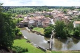
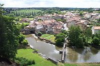
In order downstream, the Thouet flows through:
- SecondignySecondignySecondigny is a commune in the Deux-Sèvres department in western France.It is situated about 14 km west of the town of Parthenay and 35 km north of Niort....
- Azay-sur-ThouetAzay-sur-ThouetAzay-sur-Thouet is a commune in the Deux-Sèvres department in the Poitou-Charentes region in western France. It is situated on the River Thouet some east of Secondigny and 9 km west of the town of Parthenay.-References:*...
- le TalludLe TalludLe Tallud is a commune in the Deux-Sèvres department in western France.It is situated on the River Thouet some 5 km west of the town of Parthenay.-References:*...
- ParthenayParthenayParthenay is an ancient fortified town and commune in the Poitou-Charentes region in western France, sited on a rocky spur that is surrounded on two sides by the River Thouet...
- Châtillon-sur-ThouetChâtillon-sur-ThouetChâtillon-sur-Thouet is a commune in the Deux-Sèvres department in the Poitou-Charentes region in western France. It is situated on the River Thouet to the north of the town of Parthenay, with which it forms a contiguous built-up area.-References:*...
- GourgéGourgéGourgé is a commune in the Deux-Sèvres department in the Poitou-Charentes region in western France. It is from Parthenay.-Features:Gourgé has a ninth century church, an old Roman bridge over the River Thouet. Famous for its fete du medieval...
- Saint-Loup-LamairéSaint-Loup-LamairéSaint-Loup-Lamairé is a commune in the Deux-Sèvres department in western France.The commune was formed in 1974 by the merger of two former communes: Saint-Loup-sur-Thouet and Lamairé....
- AirvaultAirvaultAirvault is a commune in the Deux-Sèvres department in the Poitou-Charentes region in western France. It is located on the River Thouet.The inhabitants of Airvault are the and the .-Historical sites:...
- Saint-GénérouxSaint-GénérouxSaint-Généroux is a commune in the Deux-Sèvres department in western France.It is situated on the River Thouet some 15 km upstream from the town of Thouars.-References:*...
- MisséMisséMissé is a commune in the Deux-Sèvres department in western France.It is situated on the River Thouet some 5 km upstream from the town of Thouars, and is the site of a spectacular loop in the river.-References:*...
- ThouarsThouarsThouars is a commune in the Deux-Sèvres department in western France.It is on the River Thouet. Its inhabitants are known as Thouarsais.-History:...
- TaizonTaizonTaizon is a village in the Poitou-Charentes région of France.-Overview:It is situated on the River Thouet some 9 km north of the town of Thouars...
- Saint-Martin-de-SanzaySaint-Martin-de-SanzaySaint-Martin-de-Sanzay is a commune in the Deux-Sèvres department in western France.-References:*...
- Montreuil-BellayMontreuil-BellayMontreuil-Bellay is a commune in the Maine-et-Loire department in western France.It is located c. 15 km to the south of Saumur, and is famous for the Château de Montreuil-Bellay, which is situated in the town....
- Saint-Just-sur-DiveSaint-Just-sur-DiveSaint-Just-sur-Dive is a commune in the Maine-et-Loire department in western France.-References:*...
- SaumurSaumurSaumur is a commune in the Maine-et-Loire department in western France.The historic town is located between the Loire and Thouet rivers, and is surrounded by the vineyards of Saumur itself, Chinon, Bourgueil, Coteaux du Layon, etc...
The principal tributaries
Tributary
A tributary or affluent is a stream or river that flows into a main stem river or a lake. A tributary does not flow directly into a sea or ocean...
of the River Thouet are:
- The Viette, at Parthenay on the right bank
- The Palais, at Parthenay on the left bank
- The Cébron, at Saint-Loup-Lamairé on the left bank
- The ThouaretThouaretThe Thouaret is a 52 km long river in France, right tributary of the Thouet. Its source is in the commune Chanteloup. Its course crosses the department of Deux-Sèvres. It flows northeast through the towns of La Chapelle-Saint-Laurent, Chiché and Saint-Varent, finally flowing into the Thouet near...
, near TaizéTaizé, Deux-SèvresTaizé is a commune in the Deux-Sèvres department in western France, one of three that share the name, confusing several hundred pilgrims a year.-References:*...
on the left bank - The ArgentonArgenton RiverThe Argenton is a 71 km long river in France, left tributary of the Thouet. Its source is in the commune Cirières. Its course crosses the department of Deux-Sèvres...
, at Saint-Martin-de-Sanzay on the left bank - The Losse, at Montreuil-Bellay on the right bank
- The DiveDive RiverThe Dive is a 75 km long river in France, right tributary of the Thouet. Its source is in the commune Maisonneuve. Its course crosses the departments of Vienne, Deux-Sèvres and Maine-et-Loire. It flows northwards through the towns of Moncontour and Brézé, finally flowing into the Thouet in...
, at Saint-Just-sur-Dive on the right bank.
For much of its length, the Thouet is paralleled by the GR 36
GR 36
The GR 36 is a long-distance walking route of the Grande Randonnée network in France. The route connects Ouistreham, on the Normandy coast of the English Channel, with Bourg-Madame, on the Pyrenees border with Spain.Along the way, the route passes through:...
long-distance walking route
Long-distance trail
Long-distance trails are the longer recreational trails mainly through rural areas, used for non-motorised recreational travelling ....
, which connects Ouistreham
Ouistreham
Ouistreham is a commune in the Calvados department' in the Basse-Normandie region in northwestern France.Ouistreham is a small port with fishing boats, leisure craft and a ferry-harbour. It serves as the port of the city of Caen. The town is about the mouth of the Canal de Caen à la...
, on the coast of the English Channel
English Channel
The English Channel , often referred to simply as the Channel, is an arm of the Atlantic Ocean that separates southern England from northern France, and joins the North Sea to the Atlantic. It is about long and varies in width from at its widest to in the Strait of Dover...
, with Bourg-Madame
Bourg-Madame
Bourg-Madame is a commune in the Pyrénées-Orientales department in southern France.It lies right on the border with Spain. It abuts directly onto the Spanish town of Puigcerdà, and is near the Spanish exclave of Llívia....
, on the border with Spain
Spain
Spain , officially the Kingdom of Spain languages]] under the European Charter for Regional or Minority Languages. In each of these, Spain's official name is as follows:;;;;;;), is a country and member state of the European Union located in southwestern Europe on the Iberian Peninsula...
. This stretch of the path traces the footsteps of pilgrims
Pilgrims
Pilgrims , or Pilgrim Fathers , is a name commonly applied to early settlers of the Plymouth Colony in present-day Plymouth, Massachusetts, United States...
from Brittany
Brittany
Brittany is a cultural and administrative region in the north-west of France. Previously a kingdom and then a duchy, Brittany was united to the Kingdom of France in 1532 as a province. Brittany has also been referred to as Less, Lesser or Little Britain...
and Normandy
Normandy
Normandy is a geographical region corresponding to the former Duchy of Normandy. It is in France.The continental territory covers 30,627 km² and forms the preponderant part of Normandy and roughly 5% of the territory of France. It is divided for administrative purposes into two régions:...
on their way to Santiago de Compostela
Santiago de Compostela
Santiago de Compostela is the capital of the autonomous community of Galicia, Spain.The city's Cathedral is the destination today, as it has been throughout history, of the important 9th century medieval pilgrimage route, the Way of St. James...
, and in places crosses the river using the same ford
Ford (crossing)
A ford is a shallow place with good footing where a river or stream may be crossed by wading or in a vehicle. A ford is mostly a natural phenomenon, in contrast to a low water crossing, which is an artificial bridge that allows crossing a river or stream when water is low.The names of many towns...
s, packhorse bridge
Packhorse bridge
A packhorse bridge is a bridge intended to carry packhorses across a river or stream. Typically a packhorse bridge consists of one or more narrow masonry arches, and has low parapets so as not to interfere with the horse's panniers.Packhorse bridges were often built on the trade routes that...
s and stepping stone
Stepping stone
Stepping stone and similar can refer to:* Step-stone bridge, stones placed in a river to allow pedestrians to cross* Stepping stone , a type of computer security measure...
s the pilgrims would have used.
Navigation
The Thouet was once navigable between its confluence with the Loire and Montreuil-Bellay. The first mention of navigation on the river dates from 1430 when an assembly of merchants in Saumur suggested the creation of a navigation over this stretch of the river, requiring the creation of passages through three mill weirsWeir
A weir is a small overflow dam used to alter the flow characteristics of a river or stream. In most cases weirs take the form of a barrier across the river that causes water to pool behind the structure , but allows water to flow over the top...
. It is possible that boats were already carrying goods on the river before that date, the cargo being transferred between boats at each obstacle.
King Charles VII
Charles VII of France
Charles VII , called the Victorious or the Well-Served , was King of France from 1422 to his death, though he was initially opposed by Henry VI of England, whose Regent, the Duke of Bedford, ruled much of France including the capital, Paris...
authorised the start of work by letters patent
Letters patent
Letters patent are a type of legal instrument in the form of a published written order issued by a monarch or president, generally granting an office, right, monopoly, title, or status to a person or corporation...
, financing the work by allowing the lords of Montreuil-Bellay to raise a tax on wine that would pass through their land. In the 15th and 16th centuries, the passage through the weirs probably took the form of flash lock
Flash lock
Early locks were designed with a single gate, known as a flash lock or staunch lock. The earliest European references to what were clearly flash locks were in Roman times....
s. The later pound lock may have been introduced towards the end of the 16th century, and it is known that three pound locks were in use on the river by 1608. A project to make the river navigable up to Thouars was proposed in 1746 but was never executed.
The River Dive, a tributary of the Thouet, was canalised in 1834 to create the Canal de la Dive. As part of this development, two modern pound locks with straight sides and mitred gates were built on the Thouet, downstream of the confluence with the Dive. A third modern lock was built at the same time on the Thouet, but upstream from the confluence of the Dive. These locks had dimensions of 32 m (105 ft) length, 5.2 m (17.1 ft) width, and a draught of 1.6 m (5.2 ft).
However the new navigation soon faced competition from better roads and the railway, which appeared in the region in 1874. The maximum boat size imposed by the locks proved insufficient, and a proposed enlargement to the larger Freycinet gauge
Freycinet gauge
The Freycinet gauge is a standard governing the dimensions of the locks of some canals, put in place as a result of a law passed during the tenure of Charles de Freycinet as prime minister of France, dating from 5 August 1879....
was never realized. The last commercial navigation on the river was in 1920.