
The Dorchesterway
Encyclopedia
The Dorchesterway was a parkway
planned by 19th century landscape designer Frederick Law Olmsted
to be a continuation of the Emerald Necklace
park network in Boston, Massachusetts. This plan, however, was never implemented.
 The Emerald Necklace, as extant today, has a sort of "L" shape. It starts at the Boston Common
near Downtown Crossing
and extends out to the Arnold Arboretum (which starts in Forest Hills
but has portions in Roslindale near the West Roxbury border). It then changes direction back inwards as the Arboretum connects via the Arborway
to Franklin Park
.
Olmsted wanted the Emerald Necklace to continue via the Dorchesterway to the shore of Boston Harbor’s
Dorchester Bay and thus form a "U" shape. He intended Columbia Road in Dorchester and the Strandway (the southern roadway of which is now known as William J. Day Boulevard) in South Boston to connect South Boston's Marine Park and Pleasure Bay to the network of natural-looking green space
s he had designed.
However:
and neglected for almost a century, the area that would have been the Dorchesterway has undergone some aesthetic improvement in the last decade. The Boston Department of Parks and Recreation planted and has been maintaining tree
s, grass, planters and other vegetation
along one section of Columbia Road.
But despite the recent greening of parts of Columbia Road, natural elements in this area remain meager due to the dense neighborhood development. For this reason, the corridor is not a parkway along the lines of other sections of the Emerald Necklace in nearby Jamaica Plain, and Columbia Road is not considered part of the Emerald Necklace.
 It is possible that some incarnation of a Dorchesterway connecting the Emerald Necklace to the seashore might someday come into being. Members of the Emerald Necklace Conservancy,http://www.emeraldnecklace.org/index.cgi expressing a long-term vision for the Boston Parks system, have proposed using Columbia Road to enhance the connections between Franklin Park, Marine Park and Pleasure Bay via Columbia Road. Linking to South Boston has also been discussed. According to Simone Auster, former director of the Emerald Necklace Conservancy:
A representative of the Boston Department of Parks and Recreation said:
In 2004, the Boston Redevelopment Authority
published a strategic plan for the improvement of Roxbury
. It said that implementation of MBTA transit service along Columbia Road would grant local residents greatly improved accessibility to elements of the Emerald Necklace. Planners also recommended major street reconstruction, including trees and antique-style lamp posts, to give Columbia Road the character of a pleasant boulevard.
Parkway
The term parkway has several distinct principal meanings and numerous synonyms around the world, for either a type of landscaped area or a type of road.Type of landscaped area:...
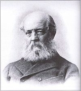
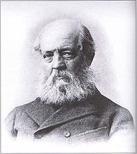
planned by 19th century landscape designer Frederick Law Olmsted
Frederick Law Olmsted
Frederick Law Olmsted was an American journalist, social critic, public administrator, and landscape designer. He is popularly considered to be the father of American landscape architecture, although many scholars have bestowed that title upon Andrew Jackson Downing...
to be a continuation of the Emerald Necklace
Emerald Necklace
The Emerald Necklace consists of an chain of parks linked by parkways and waterways in Boston and Brookline, Massachusetts. It gets its name from the way the planned chain appears to hang from the "neck" of the Boston peninsula, although it was never fully constructed.-Overview:The Necklace...
park network in Boston, Massachusetts. This plan, however, was never implemented.
Olmsted's vision
Boston Common
Boston Common is a central public park in Boston, Massachusetts. It is sometimes erroneously referred to as the "Boston Commons". Dating from 1634, it is the oldest city park in the United States. The Boston Common consists of of land bounded by Tremont Street, Park Street, Beacon Street,...
near Downtown Crossing
Downtown Crossing
Downtown Crossing is a shopping district in Boston, Massachusetts, located due east of Boston Common and west of the Financial District. It features large department stores as well as restaurants, music stores, souvenir sellers, general retail establishments, and many street vendors...
and extends out to the Arnold Arboretum (which starts in Forest Hills
Forest Hills, Boston
Forest Hills is a part of the Jamaica Plain neighborhood of Boston, Massachusetts, United States.-Overview:As the name indicates, Forest Hills is characterized by hilly terrain and wooded areas within and adjacent to its borders...
but has portions in Roslindale near the West Roxbury border). It then changes direction back inwards as the Arboretum connects via the Arborway
The Arborway
The Arborway consists of a four-lane, divided parkway and a two lane residential street in the Jamaica Plain neighborhood of Boston, Massachusetts. It was designed by Frederick Law Olmsted in the 1890s as the south most carriage road in a series of parkways connecting parks from Boston Common in...
to Franklin Park
Franklin Park, Boston
Franklin Park, a partially wooded parkland in the Jamaica Plain, Roxbury, and Dorchester neighborhoods of Boston, Massachusetts, is maintained by the City of Boston Parks and Recreation Department...
.
Olmsted wanted the Emerald Necklace to continue via the Dorchesterway to the shore of Boston Harbor’s
Boston Harbor
Boston Harbor is a natural harbor and estuary of Massachusetts Bay, and is located adjacent to the city of Boston, Massachusetts. It is home to the Port of Boston, a major shipping facility in the northeast.-History:...
Dorchester Bay and thus form a "U" shape. He intended Columbia Road in Dorchester and the Strandway (the southern roadway of which is now known as William J. Day Boulevard) in South Boston to connect South Boston's Marine Park and Pleasure Bay to the network of natural-looking green space
Open space reserve
Open space reserve, open space preserve, and open space reservation, are planning and conservation ethics terms used to describe areas of protected or conserved land or water on which development is indefinitely set aside...
s he had designed.
However:
...conditions of Columbia Road when the parks system was being established [...] precluded this vision from becoming a reality. When Columbia Road was formally designed in the late 1800s, there was already a relatively high density of buildings. The road had street rails that were used by a streetcar trolley connecting Uphams Corner and Franklin ParkFranklin ParkFranklin Park may refer to some places in the United States:* Franklin Park, Boston, a large public park in Boston, Massachusetts* Franklin Park, Florida* Franklin Park, Illinois* Franklin Park, New Jersey* Franklin Park, Oakland...
. There was a grassGrassGrasses, or more technically graminoids, are monocotyledonous, usually herbaceous plants with narrow leaves growing from the base. They include the "true grasses", of the Poaceae family, as well as the sedges and the rushes . The true grasses include cereals, bamboo and the grasses of lawns ...
strip in the center and roads on either side, one for commercial traffic and the other for pleasure traffic. As a result, Columbia Road failed to serve the purposes of either the businesses or the pleasure travelers well, and there was not enough room for what Olmsted considered a proper parkwayParkwayThe term parkway has several distinct principal meanings and numerous synonyms around the world, for either a type of landscaped area or a type of road.Type of landscaped area:...
.
The area today
Located in an area of urban blightUrban decay
Urban decay is the process whereby a previously functioning city, or part of a city, falls into disrepair and decrepitude...
and neglected for almost a century, the area that would have been the Dorchesterway has undergone some aesthetic improvement in the last decade. The Boston Department of Parks and Recreation planted and has been maintaining tree
Tree
A tree is a perennial woody plant. It is most often defined as a woody plant that has many secondary branches supported clear of the ground on a single main stem or trunk with clear apical dominance. A minimum height specification at maturity is cited by some authors, varying from 3 m to...
s, grass, planters and other vegetation
Vegetation
Vegetation is a general term for the plant life of a region; it refers to the ground cover provided by plants. It is a general term, without specific reference to particular taxa, life forms, structure, spatial extent, or any other specific botanical or geographic characteristics. It is broader...
along one section of Columbia Road.
But despite the recent greening of parts of Columbia Road, natural elements in this area remain meager due to the dense neighborhood development. For this reason, the corridor is not a parkway along the lines of other sections of the Emerald Necklace in nearby Jamaica Plain, and Columbia Road is not considered part of the Emerald Necklace.
The future
...a vision for a "completed" Emerald Necklace has not yet been flushed out by the Conservancy or other groups, but the idea of the system connecting to Pleasure Bay and Castle Island via Columbia Road and eventually back to Back Bay FensBack Bay FensThe Back Bay Fens, most commonly called simply The Fens, is a parkland and urban wild in Boston, Massachusetts, in the United States.Designed by Frederick Law Olmsted to serve as a link in the Emerald Necklace park system, the Fens gives its name to the Fenway-Kenmore neighborhood, and thereby to...
or Boston Common resonates with many Bostonians.
A representative of the Boston Department of Parks and Recreation said:
It should be a priority to reconnect Columbia Road and give it a boulevardBoulevardA Boulevard is type of road, usually a wide, multi-lane arterial thoroughfare, divided with a median down the centre, and roadways along each side designed as slow travel and parking lanes and for bicycle and pedestrian usage, often with an above-average quality of landscaping and scenery...
feeling. The quality of space, the mature trees and grass -- they should be as much a part of making this area feel special as on the opposite side.
In 2004, the Boston Redevelopment Authority
Boston Redevelopment Authority
The Boston Redevelopment Authority is the municipal planning and development agency for Boston, working on both housing and commercial developments.The BRA was established by the Boston city council and the Massachusetts legislature in 1957...
published a strategic plan for the improvement of Roxbury
Roxbury, Massachusetts
Roxbury is a dissolved municipality and current neighborhood of Boston, Massachusetts, United States. It was one of the first towns founded in the Massachusetts Bay Colony in 1630, and became a city in 1846 until annexed to Boston on January 5, 1868...
. It said that implementation of MBTA transit service along Columbia Road would grant local residents greatly improved accessibility to elements of the Emerald Necklace. Planners also recommended major street reconstruction, including trees and antique-style lamp posts, to give Columbia Road the character of a pleasant boulevard.