
The Cove Palisades State Park
Encyclopedia
State park
State parks are parks or other protected areas managed at the federated state level within those nations which use "state" as a political subdivision. State parks are typically established by a state to preserve a location on account of its natural beauty, historic interest, or recreational...
in eastern Jefferson County
Jefferson County, Oregon
Jefferson County is a county located in the U.S. state of Oregon. In 2010, its population was 21,720. It is named after Mount Jefferson. The seat of the county is Madras.-History:...
, Oregon
Oregon
Oregon is a state in the Pacific Northwest region of the United States. It is located on the Pacific coast, with Washington to the north, California to the south, Nevada on the southeast and Idaho to the east. The Columbia and Snake rivers delineate much of Oregon's northern and eastern...
, near Culver
Culver, Oregon
Culver is a city in Jefferson County, Oregon, United States. The population was 802 at the 2000 census, with an estimated population of 1,315 in 2007.- History :...
and Madras
Madras, Oregon
Madras is a city in Jefferson County, Oregon, United States. Originally called The Basin after the circular valley the city is located in, it is unclear as to whether Madras was named in 1903 for the cotton fabric called "Madras" that originated in the Madras area in India, or from the city of...
in the central
Central Oregon
Central Oregon is a geographic region in the U.S. state of Oregon and is traditionally considered to be made up of Deschutes, Jefferson, and Crook counties. Other definitions include larger areas, often encompassing areas to the north towards the Columbia River, eastward towards Burns, or south...
part of the state, and is administered by the Oregon Parks and Recreation Department
Oregon Parks and Recreation Department
The Oregon Parks and Recreation Department , officially known as the State Parks and Recreation Department, is the government agency of the U.S. state of Oregon which operates its system of state parks...
. It is located on the waters and surrounding lands of Lake Billy Chinook, an impoundment
Dam
A dam is a barrier that impounds water or underground streams. Dams generally serve the primary purpose of retaining water, while other structures such as floodgates or levees are used to manage or prevent water flow into specific land regions. Hydropower and pumped-storage hydroelectricity are...
of the Crooked
Crooked River (Oregon)
The Crooked River is a tributary, long, of the Deschutes River in the U.S. state of Oregon. The river begins at the confluence of South Fork Crooked River and Beaver Creek. Of the two tributaries, the South Fork Crooked River is the larger and is sometimes considered part of the Crooked River proper...
, Deschutes, and Metolius
Metolius River
The Metolius River is a tributary of the Deschutes River in Central Oregon, United States, near the city of Sisters. The river flows north from springs near Black Butte, then turns sharply east, descending through a series of gorges before ending in the western end of the lake...
Rivers.
Visitor opportunities
The park offers two full-service campgrounds, rental cabins, food and supplies for sale, marina access to Lake Billy Chinook with watercraft rentals, fishing, day use and picnic areas, and hiking trails. The park also offers historical interpretation, which includes the Crooked River PetroglyphPetroglyph
Petroglyphs are pictogram and logogram images created by removing part of a rock surface by incising, picking, carving, and abrading. Outside North America, scholars often use terms such as "carving", "engraving", or other descriptions of the technique to refer to such images...
in the park.
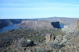
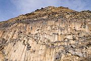
Lake Billy Chinook
Lake Billy Chinook lies in canyons carved by the three rivers into earth held in place by basaltic caprock. Construction of the Round Butte DamRound Butte Dam
Round Butte Dam is a rockfill-type hydroelectric dam on the Deschutes River, in the U.S. state of Oregon. It is located in Jefferson County. Its reservoir is called Lake Billy Chinook.-References:...
was completed in 1964 across the Deschutes River. Operated by Portland General Electric
Portland General Electric
Portland General Electric is an electrical utility based in Portland in the U.S. state of Oregon. It distributes electricity to customers in parts of Multnomah, Clackamas, Marion, Yamhill, Washington, and Polk counties - half of the inhabitants of Oregon...
(PGE), and jointly owned by PGE and the Confederated Tribes of Warm Springs
Confederated Tribes of Warm Springs
The Confederated Tribes of Warm Springs is a federally recognized confederation of Native American Tribes who currently live on and govern the Warm Springs Indian Reservation in the U.S...
, the dam and lake primarily provide electric generation for thousands of homes throughout the state. The Confederated Tribes named the lake in honor of Billy Chinook
Billy Chinook
Billy Chinook was a member of the Wasco Indian tribe. He acted as a guide for John C. Frémont in the region of Central Oregon. In the summer 1866 Bill Chinook and over twenty other Indian scouts mostly made up of Wascos spotted a Paiute camp near Dry Creek, 13 miles south of Ochoco Creek...
, a member of the Wasco tribe who acted as a guide for John C. Frémont
John C. Frémont
John Charles Frémont , was an American military officer, explorer, and the first candidate of the anti-slavery Republican Party for the office of President of the United States. During the 1840s, that era's penny press accorded Frémont the sobriquet The Pathfinder...
in the region of the lake. The lake extends beyond the boundaries of The Cove Palisades State Park.
Although fish passage facilities were installed at Round Butte Dam, anadromous fish, such as Chinook salmon
Chinook salmon
The Chinook salmon, Oncorhynchus tshawytscha, is the largest species in the pacific salmon family. Other commonly used names for the species include King salmon, Quinnat salmon, Spring salmon and Tyee salmon...
, have failed to pass the dam. As a result, since the dam's completion migratory fish have been blocked from once-abundant spawning grounds on the upper Deschutes River and tributaries such as the Crooked River.
Research natural area
Embraced by the Crooked River and Deschutes River Arms of Lake Billy Chinook, the isolated, 200 acre (0.809372 km²) plateau called The Island (actually a peninsula, but with the appearance of an island due to its isolation by high, sheer cliffs) was designated a research natural areaResearch Natural Area
Research Natural Area is a designation for certain protected areas in the United States.Research Natural Areas are part of a nationwide network of ecological areas set aside for both research and education. The network includes areas managed by many Federal agencies...
in 1986. The Island supports one of the last relatively pristine remnants of pre-settlement ecology in the western United States
Western United States
.The Western United States, commonly referred to as the American West or simply "the West," traditionally refers to the region comprising the westernmost states of the United States. Because the U.S. expanded westward after its founding, the meaning of the West has evolved over time...
, and was closed to most public access in 1997.
See also
- List of Oregon State Parks
- List of lakes in Oregon
- Lake Billy Chinook AirportLake Billy Chinook AirportLake Billy Chinook Airport , formerly known as Lake Billy Chinook State Airport, is a public airport located six miles west of the central business district of Culver, in Jefferson County, Oregon, United States...