Tehri dam
Encyclopedia
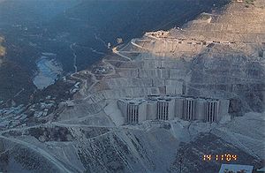
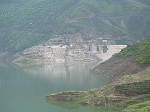
The Tehri Dam is a multi-purpose rock and earth-fill embankment dam
on the Bhagirathi River
near Tehri
in Uttarakhand
, India
. It is the primary dam of the Tehri Hydro Development Corporation Ltd. and the Tehri hydroelectric
complex. Phase 1 was completed in 2006, the Tehri Dam withholds a reservoir for irrigation
, municipal water supply and the generation of 1,000 MW of hydroelectricity. Two more phases with an additional 400 MW run-of-the-river and 1,000 MW pumped storage hydroelectricity are under construction.
 A preliminary investigation for the Tehri Dam Project was completed in 1961 and its design was completed in 1972 with a 600 MW capacity power plant based on the study. Construction began in 1978 after feasibility studies but was delayed due to financial, environmental and social impacts. In 1986, technical and financial assistance was provided by the USSR
but this was interrupted years later with political instability. India was forced to take control of the project and at first it was placed under the direction of the Irrigation Department of Uttar Pradesh. However, in 1988 the Tehri Hydro Development Corporation was formed to manage the dam and 75% of the funding would be provide by the federal government, 25% by the state. Uttar Pradesh would finance the entire irrigation portion of the project. In 1990, the project was reconsidered and the design changed to its current multi-purpose. Construction of the Tehri Dam was complete in 2006 while the second part of the project, the Koteshwar Dam
, is nearly complete with two out of four generators operational. The other two are expected to be commissioned in March 2012 while the pumped storage power planned is slated for commissioning in February 2016.
The Tehri Dam and the Tehri Pumped Storage Hydroelectric Power Plant are part of the Tehri Hydropower Complex which also includes the 400 MW Koteshwar Dam downstream. The complex will afford irrigation
to an area of 270000 hectares (667,183.9 acre), irrigation stabilization to an area of 600000 hectares (1,482,631 acre), and a supply of 270000000 gallon of drinking water per day to the industrialized areas of Delhi
, Uttar Pradesh
and Uttarakhand
.
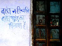
 The Tehri Dam has been the object of protests by environmental organizations and local people of the region. In addition to the human rights concerns, the project has spurred concerns about the environmental consequences of locating a large dam in the fragile ecosystem
of the Himalayan foothills. There are further concerns regarding the dam's geological stability. The Tehri dam is located in the Central Himalayan Seismic Gap, a major geologic fault
zone. This region was the site of a 6.8 magnitude
earthquake
in October 1991, with an epicenter
500 kilometres (310.7 mi) from the location of the dam. Dam proponents claim that the complex is designed to withstand an earthquake of 8.4 magnitude, but some seismologists say that earthquakes with a magnitude of 8.5 or more could occur in this region . Were such a catastrophe to occur, the potentially resulting dam-break would submerge numerous towns downstream, whose populations total near half a million.
 The relocation of more than 100,000 people from the area has led to protracted legal battles over resettlement rights, and ultimately resulted in the project's delayed completion.
Since 2005, filling of the reservoir has led to the reduced flow of Bhagirathi water from the normal 1000 cuft/s to a mere 200 cuft/s. This reduction has been central to local protest against the dam, since the Bhagirathi is considered part of the sacred Ganges whose waters are crucial to Hindu
beliefs. At some points during the year, the tampering with Bhagirathi waters means this tributary stops flowing. This has created resentment among many Hindus, as the sanctity of the Ganges has been greatly compromised for the generation of electricity.Though the officials say that when the reservoir is filled to its maximum capacity the flow of the river will again become normal. In spite of concerns and protestation, operation of the Tehri Dam continues.
(POSOCO).
Embankment dam
An embankment dam is a massive artificial water barrier. It is typically created by the emplacement and compaction of a complex semi-plastic mound of various compositions of soil, sand, clay and/or rock. It has a semi-permanent waterproof natural covering for its surface, and a dense, waterproof...
on the Bhagirathi River
Bhagirathi River
The Bhāgīrathī is a turbulent Himalayan river in the state of Uttarakhand, India, that is the source stream of the Ganges—the major river of the Gangetic plain of Northern India and the holy river of Hinduism.-Etymology:...
near Tehri
Tehri
Tehri is a city and a municipal board in Tehri Garhwal District in the Indian state of Uttarakhand. It is the administrative seat of Tehri Garhwal District.-History:...
in Uttarakhand
Uttarakhand
Uttarakhand , formerly Uttaranchal, is a state in the northern part of India. It is often referred to as the Land of Gods due to the many holy Hindu temples and cities found throughout the state, some of which are among Hinduism's most spiritual and auspicious places of pilgrimage and worship...
, India
India
India , officially the Republic of India , is a country in South Asia. It is the seventh-largest country by geographical area, the second-most populous country with over 1.2 billion people, and the most populous democracy in the world...
. It is the primary dam of the Tehri Hydro Development Corporation Ltd. and the Tehri hydroelectric
Hydroelectricity
Hydroelectricity is the term referring to electricity generated by hydropower; the production of electrical power through the use of the gravitational force of falling or flowing water. It is the most widely used form of renewable energy...
complex. Phase 1 was completed in 2006, the Tehri Dam withholds a reservoir for irrigation
Irrigation
Irrigation may be defined as the science of artificial application of water to the land or soil. It is used to assist in the growing of agricultural crops, maintenance of landscapes, and revegetation of disturbed soils in dry areas and during periods of inadequate rainfall...
, municipal water supply and the generation of 1,000 MW of hydroelectricity. Two more phases with an additional 400 MW run-of-the-river and 1,000 MW pumped storage hydroelectricity are under construction.
History

Soviet Union
The Soviet Union , officially the Union of Soviet Socialist Republics , was a constitutionally socialist state that existed in Eurasia between 1922 and 1991....
but this was interrupted years later with political instability. India was forced to take control of the project and at first it was placed under the direction of the Irrigation Department of Uttar Pradesh. However, in 1988 the Tehri Hydro Development Corporation was formed to manage the dam and 75% of the funding would be provide by the federal government, 25% by the state. Uttar Pradesh would finance the entire irrigation portion of the project. In 1990, the project was reconsidered and the design changed to its current multi-purpose. Construction of the Tehri Dam was complete in 2006 while the second part of the project, the Koteshwar Dam
Koteshwar Dam
The Koteshwar Dam is a gravity dam on the Bhagirathi River, located downstream of the Tehri Dam in Tehri District, Uttarakhand, India. The dam is part of the Tehri Hydropower Complex and serves to regulate the Tehri Dam's tailrace for irrigation and create the lower reservoir of the Tehri Pumped...
, is nearly complete with two out of four generators operational. The other two are expected to be commissioned in March 2012 while the pumped storage power planned is slated for commissioning in February 2016.
Technical description
The dam is a 260 metres (853 ft) high rock and earth-fill embankment dam. Its length is 575 metres (1,886.5 ft), crest width 20 metres (65.6 ft), and base width 1128 metres (3,700.8 ft). The dam creates a reservoir of 2.6 cubic kilometre with a surface area of 52 square kilometres (20.1 sq mi). The installed hydrocapacity is 1,000 MW along with an additional 1,000 MW of pumped storage hydroelectricity.The Tehri Dam and the Tehri Pumped Storage Hydroelectric Power Plant are part of the Tehri Hydropower Complex which also includes the 400 MW Koteshwar Dam downstream. The complex will afford irrigation
Irrigation
Irrigation may be defined as the science of artificial application of water to the land or soil. It is used to assist in the growing of agricultural crops, maintenance of landscapes, and revegetation of disturbed soils in dry areas and during periods of inadequate rainfall...
to an area of 270000 hectares (667,183.9 acre), irrigation stabilization to an area of 600000 hectares (1,482,631 acre), and a supply of 270000000 gallon of drinking water per day to the industrialized areas of Delhi
Delhi
Delhi , officially National Capital Territory of Delhi , is the largest metropolis by area and the second-largest by population in India, next to Mumbai. It is the eighth largest metropolis in the world by population with 16,753,265 inhabitants in the Territory at the 2011 Census...
, Uttar Pradesh
Uttar Pradesh
Uttar Pradesh abbreviation U.P. , is a state located in the northern part of India. With a population of over 200 million people, it is India's most populous state, as well as the world's most populous sub-national entity...
and Uttarakhand
Uttarakhand
Uttarakhand , formerly Uttaranchal, is a state in the northern part of India. It is often referred to as the Land of Gods due to the many holy Hindu temples and cities found throughout the state, some of which are among Hinduism's most spiritual and auspicious places of pilgrimage and worship...
.
Environmental issues

Ecosystem
An ecosystem is a biological environment consisting of all the organisms living in a particular area, as well as all the nonliving , physical components of the environment with which the organisms interact, such as air, soil, water and sunlight....
of the Himalayan foothills. There are further concerns regarding the dam's geological stability. The Tehri dam is located in the Central Himalayan Seismic Gap, a major geologic fault
Geologic fault
In geology, a fault is a planar fracture or discontinuity in a volume of rock, across which there has been significant displacement along the fractures as a result of earth movement. Large faults within the Earth's crust result from the action of tectonic forces...
zone. This region was the site of a 6.8 magnitude
Moment magnitude scale
The moment magnitude scale is used by seismologists to measure the size of earthquakes in terms of the energy released. The magnitude is based on the seismic moment of the earthquake, which is equal to the rigidity of the Earth multiplied by the average amount of slip on the fault and the size of...
earthquake
Earthquake
An earthquake is the result of a sudden release of energy in the Earth's crust that creates seismic waves. The seismicity, seismism or seismic activity of an area refers to the frequency, type and size of earthquakes experienced over a period of time...
in October 1991, with an epicenter
Epicenter
The epicenter or epicentre is the point on the Earth's surface that is directly above the hypocenter or focus, the point where an earthquake or underground explosion originates...
500 kilometres (310.7 mi) from the location of the dam. Dam proponents claim that the complex is designed to withstand an earthquake of 8.4 magnitude, but some seismologists say that earthquakes with a magnitude of 8.5 or more could occur in this region . Were such a catastrophe to occur, the potentially resulting dam-break would submerge numerous towns downstream, whose populations total near half a million.

Since 2005, filling of the reservoir has led to the reduced flow of Bhagirathi water from the normal 1000 cuft/s to a mere 200 cuft/s. This reduction has been central to local protest against the dam, since the Bhagirathi is considered part of the sacred Ganges whose waters are crucial to Hindu
Hindu
Hindu refers to an identity associated with the philosophical, religious and cultural systems that are indigenous to the Indian subcontinent. As used in the Constitution of India, the word "Hindu" is also attributed to all persons professing any Indian religion...
beliefs. At some points during the year, the tampering with Bhagirathi waters means this tributary stops flowing. This has created resentment among many Hindus, as the sanctity of the Ganges has been greatly compromised for the generation of electricity.Though the officials say that when the reservoir is filled to its maximum capacity the flow of the river will again become normal. In spite of concerns and protestation, operation of the Tehri Dam continues.
Scheduling and Generation Despatch
The Scheduling and Despatch of the Tehri Hydro Power plant is done by Northern Regional Load Despatch Centre which is the apex body to ensure the integrated operation of the power system grid in the Northern region and comes under Power System Operation Corporation LimitedPower System Operation Corporation Limited
Power System Operation Corporation Limited is a wholly owned subsidiary of Power Grid Corporation of India Limited . It was formed in March 2010 to handle the power management functions of PGCIL. It is responsible to ensure the integrated operation of the Grid in a reliable,efficient and secure...
(POSOCO).
External links
- Tehri Hydro Power Complex on the Bhagirathi River in India Journal Power Technology and Engineering (formerly Hydrotechnical Construction), Springer, New York ISSN 1570-145X (Print) 1570-1468 (Online) Vol. 34, No. 8-9 / Aug, 2000 DOI 10.1023/A:1004187208788, pp 479-484, November 02, 2004

