

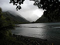
Tautira Bay
Encyclopedia
Tahiti
Tahiti is the largest island in the Windward group of French Polynesia, located in the archipelago of the Society Islands in the southern Pacific Ocean. It is the economic, cultural and political centre of French Polynesia. The island was formed from volcanic activity and is high and mountainous...
in French Polynesia
French Polynesia
French Polynesia is an overseas country of the French Republic . It is made up of several groups of Polynesian islands, the most famous island being Tahiti in the Society Islands group, which is also the most populous island and the seat of the capital of the territory...
. It is part of the commune Taiarapu-Est
Taiarapu-Est
Taiarapu-Est is a commune of French Polynesia, an overseas territory of France in the Pacific Ocean. The commune of Taiarapu-Est is located on the island of Tahiti, in the administrative subdivision of the Windward Islands, themselves part of the Society Islands.The commune extends over a part of...
. It is formed by Tautira
Tautira
Tautira is a Polynesian beach village, valley, and point on the south-east coast of the island of Tahiti in the Pacific. It is part of the commune Taiarapu-Est. With a population of 2338 , it is located 49 kilometres southeast of the Tahitian capital of Papeete on the coast of Tautira Bay, at the...
Point and reef on the eastern side, and by the barrier reef on the western side. It is reached through a gap in the reef about half a mile wide, with deep water, with Tautira point giving it protection from winds from north-east.It is 0.5 mile (0.80467 km) wide and about the same depth. The bay opens to the northwest, affording protection with winds from northeastward through east and south to west-northwestward, but can be dangerous with those between north and west-northwestward. James Cook
James Cook
Captain James Cook, FRS, RN was a British explorer, navigator and cartographer who ultimately rose to the rank of captain in the Royal Navy...
anchored several times in this bay, from which circumstance the name is derived. The depth in the middle of the entrance is from 35 to 60 fathoms, diminishing gradually to the shore. The bay is clear, except a small patch of 2 fathoms 600 feet (182.9 m) southward of the point of reef on the western side. The eastern and southeastern shore is lined with a sandy beach. The best anchorage is at about 1200 feet (365.8 m) from the shore in 8.5 fathoms, sand, with the extreme of Tautira Point bearing 45°.
The harbor in Tautira Bay is Te-'afa ("the crack"). Port Pihaa is the deep basin, from 1800–2400 ft (548.6–731.5 ) wide and 1.5 miles (2.4 km) long, between the barrier reef and the shore, extending from Tautira Bay to Pihaa Point, with depths nearly everywhere of from 16 to 19 fathoms, sand and mud. There are two openings into this port, that from the eastward from Tautira Bay being 600 feet (182.9 m) wide, but divided by a small 2-fathom patch; the other from the westward, from Taharoa Pass, is only about 60 yards wide.