

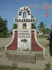
Tarangnan, Samar
Encyclopedia
Philippines
The Philippines , officially known as the Republic of the Philippines , is a country in Southeast Asia in the western Pacific Ocean. To its north across the Luzon Strait lies Taiwan. West across the South China Sea sits Vietnam...
. According to the 2000 census, it has a population of 20,538 people and 4,020 households.
History
In the second half of the nineteenth century, the island of Samar experienced a commercial boom, especially in abaca, with imports and exports of abaca products. Moro raids in the island declined due to the presence of Spaniards. As the Spaniards settled in Samar, they saw the need of all-weather seaports and easy communications for their commercial activities and political administration. This development paved the way for the convergence of the inhabitants into the old town site of Tarangnan, where transport was relatively accessible. The settlement of Tarangnan was growing at a much faster pace than the pueblo of Dapdap.
Taking into consideration the island's commercial boom, with prospects of Tarangnan as a trading center and its religious vigilance over Dapdap, on June 21, 1881, Gov. Enrique Chacon wrote to his superiors. He recommended the transfer of the Poblacion from Dapdap to Tarangnan due to the former's poor accessibility, unavailability of land area for expansion, and its unsanitary environment.
On April 1, 1884, Tarangnan was declared as one of the municipalities of the Province of Samar by means of Royal Decree by the King of Spain, King Alfonso I.
In 1957, the following sitios were declared barrios: Cabunga-an, Tigdaranao, and Binalayan.
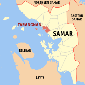
The Municipality of Tarangnan has forty-one (41) duly constituted barangays with a total land area of approximately 10,417.1435 hectares. It has a population of 18,791 based on the 1995 NSO data. The Municipality is geographically situated in the west portion of the island of Samar, bounded on the east by the municipality of Pagsanghan, in the south by the capital city of Catbalogan and on the west by the Samar Sea or Maqueda Bay. Tarangnan is accessible by either land or sea. The distance of the poblacion from the capital city of Catbalogan is about 36 km and 59.75 km away from Calbayog City. It can be reached through an 11-km road from the Maharlika highway crossing Brgy. Balugo by a provincial road. A 5th class municipality belonging to the 1st Congressional District of the Samar province, Tarangnan has its own municipal hospital which was inaugurated in 1982. It has a 10-bed capacity. It caters primarily to health services. It is augmented by Rural Health Unit extension workers. It has daycare centers which also cater the needs of pre-schoolers.
Barangays
Tarangnan is politically subdivided into 41 barangayBarangay
A barangay is the smallest administrative division in the Philippines and is the native Filipino term for a village, district or ward...
s.
|
|
|