

Tambo Colorado
Encyclopedia
Tambo Colorado is a well-preserved Inca adobe
complex near the coast of Peru
, also known as Puka Tampu, Pucallacta or Pucahuasi.
known as the Via de los Libertadores, close to the town of Pisco
. Initial reports from the 2007 Peru Earthquake
reported no major damage to the site.
A High resolution GPS point was shot at the site datum on 2 Aug 2009 using an L2 GPS (Trimble GeoXH with Zephyr).
The post-processed position is as follows:
Northings: 8484705.386 m (± 0.8 m)
Eastings: 410335.884 m (± 0.8 m)
Altitude (MSL): 484.849 m (±1.8 m)
UTM Zone 18 South, Datum WGS 1984.
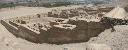
 The site consists of several structures around a large central plaza. The central plaza is shaped like a trapezoid with its largest side being 150 m long. The main structures are grouped together in a northern part and a southern part (Sector Norte and Sector Sur). These structures are known as the Northern palace and the two Southern Palaces, flanked by an Ushnu
(raised ceremonial platform) and a building known as the Utilities Structure.
Adobe
Adobe is a natural building material made from sand, clay, water, and some kind of fibrous or organic material , which the builders shape into bricks using frames and dry in the sun. Adobe buildings are similar to cob and mudbrick buildings. Adobe structures are extremely durable, and account for...
complex near the coast of Peru
Peru
Peru , officially the Republic of Peru , is a country in western South America. It is bordered on the north by Ecuador and Colombia, on the east by Brazil, on the southeast by Bolivia, on the south by Chile, and on the west by the Pacific Ocean....
, also known as Puka Tampu, Pucallacta or Pucahuasi.
Location
The site is located just inland from the south coast of Perú in the Pisco River Valley about 40 km along the highway to AyacuchoAyacucho
Ayacucho is the capital city of Huamanga Province, Ayacucho Region, Peru.Ayacucho is famous for its 33 churches, which represent one for each year of Jesus's life. Ayacucho has large religious celebrations, especially during the Holy Week of Easter...
known as the Via de los Libertadores, close to the town of Pisco
Pisco, Peru
Pisco is a city located in the Ica Region of Peru, the capital of the Pisco Province. The city is around 9 metres above sea level. Originally the villa of Pisco was founded in 1640, close to the indigenous emplacement of the same name...
. Initial reports from the 2007 Peru Earthquake
2007 Peru earthquake
The 2007 Peru earthquake was an earthquake measuring 8.0 on the moment magnitude scale that hit the central coast of Peru on Wednesday, August 15, 2007; it occurred at 23:40:57 UTC and lasted for about three minutes...
reported no major damage to the site.
A High resolution GPS point was shot at the site datum on 2 Aug 2009 using an L2 GPS (Trimble GeoXH with Zephyr).
The post-processed position is as follows:
Northings: 8484705.386 m (± 0.8 m)
Eastings: 410335.884 m (± 0.8 m)
Altitude (MSL): 484.849 m (±1.8 m)
UTM Zone 18 South, Datum WGS 1984.
History
The site was most likely built at the end of the 15th century during the reign of the Inca king Pachacuti Inca Yupanqui also known as Pachacutec.Name
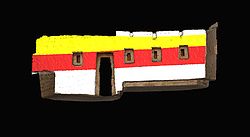
The site owes its name to the abundant use of colors on the walls. Thanks to favorable (very dry) environmental conditions, many walls at Tambo, both internal and external, retain enough residual colored paint to accurately reconstruct what the original wall painting would have been like. Color here was often applied in horizontal strips of red, black, white, and yellow ochre atop stucco, and variation in color would accentuate architectural features such as niches. Trapezoidal niches at Tambo have one or two recesses each, likely used for the placement of important objects. As with all Inca constructions, the overall dimensions of niche construction are standardized across the entire site.Lay-out
Ushnu
An ushnu is a pyramid-shaped, terraced structure that was used by the Incas to preside at the most important ceremonies of the Tawantinsuyu.- Name :Little is known of Ushnu's Quechua root, but it seemed to mean the place of stones where the water filters...
(raised ceremonial platform) and a building known as the Utilities Structure.
Use
It is believed to have been used by the Incas as an administrative and control site on the main road from the coast to the highlands.External links
- Tambo Colorado Digital Media Archive (creative commonsCreative CommonsCreative Commons is a non-profit organization headquartered in Mountain View, California, United States devoted to expanding the range of creative works available for others to build upon legally and to share. The organization has released several copyright-licenses known as Creative Commons...
-licensed photos, laser scans, panoramas), data from a UC Berkeley/CyArkCyArkCyArk is a 501 nonprofit organization located in Oakland, California, United States. The company's website refers to it as a "digital archive of the world’s heritage sites for preservation and education"...
research partnership