

Talipao, Sulu
Encyclopedia
Philippines
The Philippines , officially known as the Republic of the Philippines , is a country in Southeast Asia in the western Pacific Ocean. To its north across the Luzon Strait lies Taiwan. West across the South China Sea sits Vietnam...
.
The Municipality of Talipao’s total area coverage is pegged at approximately 38,057.00 hectares. The said figures constitute more or less 20.63 % of Sulu’s total land area.
I. Brief Historical Background
Historical: If we, people of today, were to believed what generation-age legend and old folks historical narration accounts to support the claims on the use of these known historical facts and records, the municipality of Talipao derived its names accordingly as to have been taken after the names of the couple, “Tal” and “Pao”, that of the husband’s and wife’s name respectively.
As a mere municipality district then, the municipality of Talipao was transformed into a full-pledged Local Government Unit on July 1st 1957 under the provision of the Department of Mindanao and Sulu Administrative Code.
B. Political Subdivision
Congressional District: 1st District of Sulu
No. of Barangays: Fifty Two (52)
II. Physical Features
Land Area Coverage
The Municipality of Talipao’s total area coverage is pegged at approximately 38,057.00 hectares. The said figures constitute more or less 20.63 % of Sulu’s total land area.
Boundaries
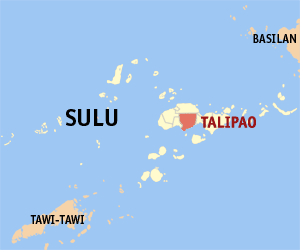
The municipality of Talipao lies within map coordinates 121*3’ E to 121*11’ E longitude and 5*52’ N latitude. That means the planning area is found right in the mid portion of the Jolo Mainland with its Barangay Poblacion basically situated in the inner most central part of the municipality. In short, it is right there in the very heart of the province of Sulu’s mainland.
From the capital town of Jolo, Talipao is connected with concrete-type national road which is approximately 22.8 kilometers away from the Sulu-Provincial Capitol Complex.
It is bounded on the north by the municipality of Patikul; on the south by Sulu Sea; on the east by the municipality of Panglima Estino; and by the municipality of Maimbung on its west side.
Land Use: (Area in Hectares)
Agriculture :
Industrial : 0.025
Forest : 4,595.2 including the mangroves
Institution : 5.1318
Commercial : 0.0788
Topography : 848-2,247 feet
Lake :
Mangrove :
Residential Area : 3.1042
III. Social Sector
A. Demography
Total Population : 73,015
Male and Female ration :
Population Density : 2.56 persons/hectare
No. of Household : 13,016
Average household size :
Birth rate :
Death rate :
B. Health
Malnutrition : 75% of school age is malnourished
Leading Causes of Mortality and Morbidity (for all ages as of June 2009):
Mortality:
1) Gunshot/Accident
2) Senility without mentioned of psychosis
3) Hypertension
4) Pneumonia
5) Malnutrition
6) Diarrhea l Disease
7) Still Birth
Morbidity:
1) Upper respiratory tract infection
2) Influenza
3) Dermatological diseases
4) Hypertension
5) Acid Peptic Disease
6) Anemia
7) Diarrhea
8) Parasitism
9) Malnutrition
10) Pneumonia
11) TB/Respiratory Infection
Health Facilities Public Private
No. of health centers 2
No. of Medical Centers None
No. of Dental Clinics None
No. of Day Care Centers 10
Health Personnel Government Private
No. of Doctors 1
No. of Nurses 1
No. of Districts None
No. of midwives 10
Sanitary Inspectors 2
Malaria Lab. Tech. 1
C. Education
Literacy rate 30.7%
Educational Institutions Public Private
Talipao is politically subdivided into 52 barangay
Barangay
A barangay is the smallest administrative division in the Philippines and is the native Filipino term for a village, district or ward...
s.
|
|
|