

Table Rock Indian Reservation
Encyclopedia
Indian reservation
An American Indian reservation is an area of land managed by a Native American tribe under the United States Department of the Interior's Bureau of Indian Affairs...
located north of the Rogue River
Rogue River (Oregon)
The Rogue River in southwestern Oregon in the United States flows about in a generally westward direction from the Cascade Range to the Pacific Ocean. Known for its salmon runs, whitewater rafting, and rugged scenery, it was one of the original eight rivers named in the Wild and Scenic Rivers Act...
in the U.S. state
U.S. state
A U.S. state is any one of the 50 federated states of the United States of America that share sovereignty with the federal government. Because of this shared sovereignty, an American is a citizen both of the federal entity and of his or her state of domicile. Four states use the official title of...
of Oregon
Oregon
Oregon is a state in the Pacific Northwest region of the United States. It is located on the Pacific coast, with Washington to the north, California to the south, Nevada on the southeast and Idaho to the east. The Columbia and Snake rivers delineate much of Oregon's northern and eastern...
. It was established by treaty with the Rogue River Indians
Rogue River (tribe)
Rogue River is the name of a Native American group originally located in southern Oregon in the United States. Rogue River was not a single tribe, but a conglomeration of many affiliated and related tribal groups. The total estimated population of these tribes in 1850 was about 9,500...
in 1853. Following the conclusion of the Rogue River Wars
Rogue River Wars
The Rogue River Wars was an armed conflict between the US Army, local militias and volunteers, and the Native American tribes commonly grouped under the designation of Rogue River Indians, in the Rogue River Valley area of what today is southern Oregon in 1855–56...
in 1856, the Native American
Native Americans in the United States
Native Americans in the United States are the indigenous peoples in North America within the boundaries of the present-day continental United States, parts of Alaska, and the island state of Hawaii. They are composed of numerous, distinct tribes, states, and ethnic groups, many of which survive as...
inhabitants were moved to other reservations. The reservation was located in Southern Oregon
Southern Oregon
Southern Oregon is a region of the U.S. state of Oregon south of Lane County and generally west of the Cascade Range, excluding the southern Oregon Coast. Counties include Douglas, Jackson, Klamath, and Josephine. It includes the Southern Oregon American Viticultural Area, which consists of the...
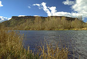
, between Upper Table Rock and Evans Creek.
History
Conflicts between miners and Rogue River Indians began in the early 1850s, when gold was discoveredGold rush
A gold rush is a period of feverish migration of workers to an area that has had a dramatic discovery of gold. Major gold rushes took place in the 19th century in Australia, Brazil, Canada, South Africa, and the United States, while smaller gold rushes took place elsewhere.In the 19th and early...
in what is now Oregon. This conflict turned into open warfare and several treaties were signed in an attempt to end the hostilities resulting in the Native Americans ceding their land. They were moved to Table Rock Reservation before being moved to the Grand Ronde Reservation and the Coast Reservation
Coast Indian Reservation
The Coast Indian Reservation is a former Indian reservation in the U.S. state of Oregon, established in 1855. It was gradually greatly reduced in size to become the present-day Siletz Reservation.-History:...
(a fraction of which is now the Siletz Reservation).
Native Americans lost most of the Bear Creek Valley in exchange for the Table Rock Reservation. In October 1855, a lack of food, a cold winter, and disease devastated the families on the reservation, so a group of Takelma
Takelma
The Takelma were a Native American people that lived in the Rogue Valley of interior southwest Oregon, with most of their villages sited along the Rogue River. The name Takelma means Along the River.-History:...
Indians returned to their old village at the mouth of Little Butte Creek
Little Butte Creek (Rogue River)
Little Butte Creek is a long tributary of the Rogue River located in the U.S. state of Oregon. Its drainage basin consists of approximately of Jackson County, and another in Klamath County. The north fork of the creek begins at Fish Lake, while the south fork begins near Brown Mountain. The two...
on the upper Rogue River
Rogue River (Oregon)
The Rogue River in southwestern Oregon in the United States flows about in a generally westward direction from the Cascade Range to the Pacific Ocean. Known for its salmon runs, whitewater rafting, and rugged scenery, it was one of the original eight rivers named in the Wild and Scenic Rivers Act...
. A volunteer militia then attacked them, killing 23 including women and children. They responded to this dire situation by fleeing to the Rogue River Canyon, attacking miners and settlers from Gold Hill
Gold Hill, Oregon
Gold Hill is a city in Jackson County, Oregon, in the United States. As of July 1, 2009, the population was 1,080 people.-Geography:According to the United States Census Bureau, the city has a total area of , all of it land.-Demographics:...
to Galice Creek on the way. The militia and regular army troops caught up with them in the canyon, and the Indians inflicted heavy casualties on the poorly trained troops. What became known as the Battle of Hungry Hill was a major victory for the Indians. In November, the militia and army again attacked, and again were defeated. The attack was meant to be a surprise, but the Native Americans heard them chopping trees to build rafts and were prepared.
Several more battles were then fought. In the spring of 1856, a force of nearly 200 volunteers arrived at the mouth of Ditch Creek on the Rogue River, and fired on the Indians' settlement on the far shore. Up to 30 Indians were killed during the day-long assault, forcing the survivors to surrender. In the summer and following winter, licensed hunters killed and captured Indians who remained in the area.
In the winter of 1856-7, 400 Indians were marched from Table Rock 200 miles north to the new Grand Ronde Reservation in Yamhill County
Yamhill County, Oregon
-National protected areas:*Siuslaw National Forest *Tualatin River National Wildlife Refuge -Demographics:As of the census of 2000, there were 84,992 people, 28,732 households, and 21,376 families residing in the county. The population density was 119 people per square mile . There were 30,270...
. The survivors of the Battle of Hungry Hill were loaded onto a steamboat at Port Orford, Oregon
Port Orford, Oregon
Port Orford is a city in Curry County, Oregon, United States. It is on the southern Oregon Coast, at the northern end of what coastal Oregonians call the Banana Belt, because the weather from Port Orford south is noticeably warmer than the weather north of nearby Cape Blanco...
then transported via the Columbia River
Columbia River
The Columbia River is the largest river in the Pacific Northwest region of North America. The river rises in the Rocky Mountains of British Columbia, Canada, flows northwest and then south into the U.S. state of Washington, then turns west to form most of the border between Washington and the state...
and Willamette River
Willamette River
The Willamette River is a major tributary of the Columbia River, accounting for 12 to 15 percent of the Columbia's flow. The Willamette's main stem is long, lying entirely in northwestern Oregon in the United States...
and then overland to the Siletz Reservation near the Oregon Coast
Oregon Coast
The Oregon Coast is a region of the U.S. state of Oregon. It runs generally north-south along the Pacific Ocean, forming the western border of the state; the region is bounded to the east by the Oregon Coast Range. The Oregon Coast stretches approximately from the Columbia River in the north to...
.
External links
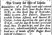
- 1853 News Article, The Treaty for Sale of Lands from the Oregon Historical SocietyOregon Historical SocietyThe Oregon Historical Society is an organization that encourages and promotes the study and understanding of the history of the Oregon Country, within the broader context of U.S. history. Incorporated in 1898, the Society collects, preserves, and makes available materials of historical character...
- The Fort Lane Archaeology Project: Historic Context from Southern Oregon UniversitySouthern Oregon Universityis a public liberal arts college located in Ashland, Oregon, United States. Founded in 1926, it was formerly known as Southern Oregon College and Southern Oregon State College . SOU offers criminology, natural sciences, including environmental science, Shakespearean studies and theatre arts programs...
- Treaty with the Rogue River, 1853 from Oklahoma State University
- Treaty with the Rogue River, 1854 from Oklahoma State University
- 1856 request to open Indian lands from the Native American Document Project
- 1857 request to open Indian lands from the Oregon State ArchivesOregon State ArchivesThe Archives Division of the Office of the Secretary of State of Oregon, or Oregon State Archives, is an agency of the Office of the Oregon Secretary of State charged with preserving and providing access to government records. It also publishes the Oregon Blue Book and Oregon Administrative Rules...