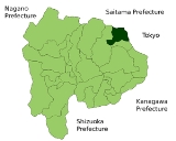
Tabayama, Yamanashi
Encyclopedia
is a village
located in Kitatsuru District
, Yamanashi
, Japan
.
As of 2007, the village has an estimated population
of 740 and a density
of 7.3 persons per km². The total area is 101.55 km².
, the village is very mountainous. Most of the village is covered by forests, and is located in Chichibu-Tama-Kai National Park.
Villages of Japan
A is a local administrative unit in Japan.It is a local public body along with , , and . Geographically, a village's extent is contained within a prefecture....
located in Kitatsuru District
Kitatsuru District, Yamanashi
is a district located in Yamanashi, Japan.As of 2003, the district has an estimated population of 29,030 and a density of 103.79 persons per km². The total area is 279.71 km².There are only two villages left in the district.*Kosuge*Tabayama-History:...
, Yamanashi
Yamanashi Prefecture
is a prefecture of Japan located in the Chūbu region of the island of Honshū. The capital is the city of Kōfu.-Pre-history to the 14th century:People have been living in the Yamanashi area for about 30,000 years...
, Japan
Japan
Japan is an island nation in East Asia. Located in the Pacific Ocean, it lies to the east of the Sea of Japan, China, North Korea, South Korea and Russia, stretching from the Sea of Okhotsk in the north to the East China Sea and Taiwan in the south...
.
As of 2007, the village has an estimated population
Population
A population is all the organisms that both belong to the same group or species and live in the same geographical area. The area that is used to define a sexual population is such that inter-breeding is possible between any pair within the area and more probable than cross-breeding with individuals...
of 740 and a density
Population density
Population density is a measurement of population per unit area or unit volume. It is frequently applied to living organisms, and particularly to humans...
of 7.3 persons per km². The total area is 101.55 km².
Geography
Located in the northeastern corner of Yamanashi PrefectureYamanashi Prefecture
is a prefecture of Japan located in the Chūbu region of the island of Honshū. The capital is the city of Kōfu.-Pre-history to the 14th century:People have been living in the Yamanashi area for about 30,000 years...
, the village is very mountainous. Most of the village is covered by forests, and is located in Chichibu-Tama-Kai National Park.
- Mountains: Mount KumotoriMount Kumotoristands at the boundary of Tokyo, Saitama, and Yamanashi Prefectures on the island of Honshū, Japan. With an elevation of , its summit is the highest point in Tokyo. It separates the Okutama Mountains and the Okuchichibu Mountains...
, Mount Hiryū, Mount Nanatsuishi, Iwadake - Rivers: Taba River, Kaizawa River, Atoyama River
- Lakes: Lake OkutamaLake Okutamais in Tokyo and Yamanashi Prefectures in Japan. Lying above the Ogōchi Dam, it is also known as the Ogōchi Reservoir. The lake occupies part of the town of Okutama in Nishitama District, Tokyo and the village of Tabayama in Kitatsuru District, Yamanashi...
Surrounding municipalities
- Yamanashi PrefectureYamanashi Prefectureis a prefecture of Japan located in the Chūbu region of the island of Honshū. The capital is the city of Kōfu.-Pre-history to the 14th century:People have been living in the Yamanashi area for about 30,000 years...
- KōshūKoshu, Yamanashiis a city located in Yamanashi Prefecture, Japan.The city was founded on November 1, 2005, when the city of Enzan was merged with the town of Katsunuma, and the village of Yamato, both from Higashiyamanashi District, to form the new city of Kōshū....
- KosugeKosuge, Yamanashiis a village located in Kitatsuru District, Yamanashi, Japan.As of 2003, the village has an estimated population of 1,041 and a density of 19.77 persons per km². The total area is 52.65 km².-External links:*...
- Kōshū
- TokyoTokyo, ; officially , is one of the 47 prefectures of Japan. Tokyo is the capital of Japan, the center of the Greater Tokyo Area, and the largest metropolitan area of Japan. It is the seat of the Japanese government and the Imperial Palace, and the home of the Japanese Imperial Family...
- OkutamaOkutama, Tokyois a town in Nishitama District, Tokyo. As of August 1, 2007, the town had a population of 6712 people, of which 3280 were men and 3432 were women. With an area of 225.63 km², it is the largest community in Tokyo. Mount Kumotori, Tokyo's highest peak at 2017 m, divides Okutama from the...
- Okutama
- Saitama PrefectureSaitama Prefectureis a prefecture of Japan located in the Kantō region of the island of Honshu. The capital is the city of Saitama.This prefecture is part of the Greater Tokyo Area, and most of Saitama's cities can be described as suburbs of Tokyo, to which a large amount of residents commute each day.- History...
- ChichibuChichibu, Saitamais a city in Saitama, Japan. As of April 1, 2011, the city has an estimated population of 68,701, with a household number of 26,230. The total area is 577.69 km²....
- Chichibu

