

São Gotardo
Encyclopedia
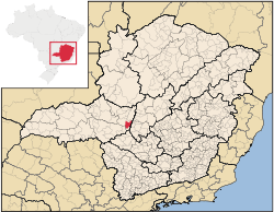
Minas Gerais
Minas Gerais is one of the 26 states of Brazil, of which it is the second most populous, the third richest, and the fourth largest in area. Minas Gerais is the Brazilian state with the largest number of Presidents of Brazil, the current one, Dilma Rousseff, being one of them. The capital is the...
. Its population as of 2007 was 30,757 people and its land area is 854 km2. The city belongs to the mesoregion
Mesoregion (Brazil)
Mesoregions are subdivisions of Brazilian states, grouping together various municipalities in proximity and with common characteristics. They were created by the Brazilian Institute of Geography and Statistics for statistical purposes and do not, therefore, constitute an administrative area....
of Triângulo Mineiro
Triângulo Mineiro
The Triangle Mineiro Portuguese pronunciation: [tɾiɐɡulu minejru] is an officer in the region west of the state of Minas Gerais, Brazil. The area is 93.500 km ² and is limited by the Serra da Canastra and Marcela, east, south of Sao Paulo, Goias in the north and west of the junction of the rivers...
e Alto Paranaíba and to the microregion
Microregion (Brazil)
Microregions are legally defined administrative areas in Brazil consisting of groups of municipalities bordering urban areas. Microregions are grouped together into mesoregions....
of Patos de Minas
Patos de Minas
Patos de Minas is a city and municipality in the state of Minas Gerais in Brazil, located some 400 km from Belo Horizonte on the Paranaíba River. The city had 133,054 in 2007 while the area of the municipality is 3,189 km²...
. It became a municipality in 1915.
Location
The urban center is located at an elevation of 1,100 meters southeast of Patos de MinasPatos de Minas
Patos de Minas is a city and municipality in the state of Minas Gerais in Brazil, located some 400 km from Belo Horizonte on the Paranaíba River. The city had 133,054 in 2007 while the area of the municipality is 3,189 km²...
in the upper Abaeté River valley. The region is made up of a plateau called Mata da Corda. The climate is mild and frost can occur in the dry season (from May to September). Neighboring municipalities are: Matutina
Matutina
Matutina is a Brazilian municipality located in the northwest of the state of Minas Gerais. Its population as of 2007 was 3,700 people living in a total area of 260 km². The city belongs to the mesoregion of Triângulo Mineiro e Alto Paranaíba and to the microregion of Patos de Minas...
and Tiros
Tiros
Tiros is a Brazilian municipality located in the northwest of the state of Minas Gerais. Its population as of 2007 was 7,416 people living in a total area of 2,093 km². The city belongs to the mesoregion of Triângulo Mineiro e Alto Paranaíba and to the microregion of Patos de Minas...
to the North, Rio Paranaíba
Rio Paranaíba
Rio Paranaíba is a Brazilian municipality located in the northwest of the state of Minas Gerais. Its population as of 2007 was 10,809 people living in a total area of 1,353 km². The city belongs to the mesoregion of Triângulo Mineiro e Alto Paranaíba and to the microregion of Patos de Minas...
to the east, Campos Altos
Campos Altos
Campos Altos is a Brazilian municipality located in the west of the state of Minas Gerais. Its population as of 2007 was estimated to be 13,184 people living in a total area of 719 km². The city belongs to the mesoregion of Triângulo Mineiro and Alto Paranaíba and to the micro-region of Araxá. It...
and Santa Rosa da Serra
Santa Rosa da Serra
Santa Rosa da Serra is a Brazilian municipality located in the northwest of the state of Minas Gerais. Its population as of 2007 was 3,261 people living in a total area of 296 km². The city belongs to the mesoregion of Triângulo Mineiro e Alto Paranaíba and to the microregion of Patos de Minas...
to the south, and Quartel Geral
Quartel Geral
Quartel Geral is a Brazilian municipality located in the center of the state of Minas Gerais. Its population as of 2007 was 3,200 people living in a total area of 556 km². The city belongs to the meso-region of Central Mineira and to the micro-region of Bom Despacho...
to the west.
Distances
Image:Carrot.jpg- Patos de MinasPatos de MinasPatos de Minas is a city and municipality in the state of Minas Gerais in Brazil, located some 400 km from Belo Horizonte on the Paranaíba River. The city had 133,054 in 2007 while the area of the municipality is 3,189 km²...
: 101 km - AraxáAraxáAraxá is a city and municipality in southwest Minas Gerais state, Brazil. The population was 87,764 inhabitants and the area of the municipality is 1,283 km², with 345 km² making up the urban perimeter.-Geography:...
: 163 km - Estalagem: 55 km (BR-262)
- Rio ParanaíbaRio ParanaíbaRio Paranaíba is a Brazilian municipality located in the northwest of the state of Minas Gerais. Its population as of 2007 was 10,809 people living in a total area of 1,353 km². The city belongs to the mesoregion of Triângulo Mineiro e Alto Paranaíba and to the microregion of Patos de Minas...
: 20 km - MatutinaMatutinaMatutina is a Brazilian municipality located in the northwest of the state of Minas Gerais. Its population as of 2007 was 3,700 people living in a total area of 260 km². The city belongs to the mesoregion of Triângulo Mineiro e Alto Paranaíba and to the microregion of Patos de Minas...
: 22 km - TirosTirosTiros is a Brazilian municipality located in the northwest of the state of Minas Gerais. Its population as of 2007 was 7,416 people living in a total area of 2,093 km². The city belongs to the mesoregion of Triângulo Mineiro e Alto Paranaíba and to the microregion of Patos de Minas...
:43 km - ArapuaArapuáArapuá is a Brazilian municipality located in the northwest of the state of Minas Gerais. Its population as of 2007 was 2,699 people living in a total area of 172 km². The city belongs to the mesoregion of Triângulo Mineiro e Alto Paranaíba and to the microregion of Patos de Minas...
:50 km - Belo HorizonteBelo HorizonteBelo Horizonte is the capital of and largest city in the state of Minas Gerais, located in the southeastern region of Brazil. It is the third largest metropolitan area in the country...
: 295 km
Economic activities
The most important economic activities are cattle raising, commerce, and agriculture. The GDP in 2005 was R$277 million, with 166 million generated by services, 18 million generated by industry, and 66 million generated by agriculture. São Gotardo is in the top tier of municipalities in the state with regard to economic and social development. As of 2007, there were 05 banking agencies in the town. There was a well-developed retail infrastructure serving the surrounding area of cattle and agricultural lands. There were 5,961 automobiles in all of the municipality (2007), about one for every 05 inhabitants.São Gotardo is a large producer of agricultural products, especially coffee and corn. The high elevation combined with tropical latitude allows it to produce coffee and wheat. In the rural area there were 825 establishments (2006) occupying 61,000 hectares (planted area of 14,000 ha and natural pasture of 35,000 ha.). About 3,000 persons were dependent on agriculture.. 113 of the farms had tractors, a ratio of one in 7 farms. There were 43,000 head of cattle in 2006. The main crops were :
- avocado: 120 hectares
- coffee: 2,820 hectares
- garlic: 65 hectares
- potatoes: 110 hectares
- onions: 77 hectares
- beans: 420 hectares
- corn: 3,600 hectares
- soybeans: 1,500 hectares
- wheat: 130 hectares
Health and education
In the health sector there were 13 health clinics and 02 hospitals with 44 beds In the educational sector there were 12 pre-primary schools, 17 primary schools, and 05 middle schools.- Municipal Human Development IndexHuman Development IndexThe Human Development Index is a composite statistic used to rank countries by level of "human development" and separate "very high human development", "high human development", "medium human development", and "low human development" countries...
: 0.807 (2000) - State ranking: 30 out of 853 municipalities as of 2000
- National ranking: 439 out of 5,138 municipalities as of 2000
- Literacy rate: 88%
- Life expectancy: 73 (average of males and females)
The highest ranking municipality in Minas Gerais in 2000 was Poços de Caldas
Poços de Caldas
Poços de Caldas is a city and municipality in south-western Minas Gerais state, Brazil, in the microregion of the same name. Its estimated population in 2009 was 151,449 inhabitants...
with 0.841, while the lowest was Setubinha
Setubinha
Setubinha is a municipality in the northeast of the Brazilian state of Minas Gerais. As of 2007 the population was 10,834 in a total area of 536 km². The elevation is 729 metres. It is part of the IBGE statistical microregion of Teófilo Otoni...
with 0.568. Nationally the highest was São Caetano do Sul
São Caetano do Sul
São Caetano do Sul is a city in São Paulo state in Brazil, located in the Greater São Paulo Metropolitan Area. It is the city with the highest per capita income in Brazil and it also has the highest Human Development Index .-Geography:São Caetano do Sul is located on a plateau that is part of the...
in São Paulo with 0.919, while the lowest was Setubinha. In more recent statistics (considering 5,507 municipalities) Manari in the state of Pernambuco
Pernambuco
Pernambuco is a state of Brazil, located in the Northeast region of the country. To the north are the states of Paraíba and Ceará, to the west is Piauí, to the south are Alagoas and Bahia, and to the east is the Atlantic Ocean. There are about of beaches, some of the most beautiful in the...
has the lowest rating in the country, 467, putting it in last place.
Origin of the Name
The name is inspired by Joaquim Gotardo de Lima who arrived in the region in 1836 with his family and settled on a cattle ranch which later developed into a small settlement around a chapel. In 1852 the first settlement, known as Confusão, after a local ranch, was raised to a district with the name of São Sebastião do Pouso Alegre. Later the name was changed to pay homage to the founder, who unexpectedly gained sainthood in the new name.See also
- List of municipalities in Minas Gerais