Surcin
Encyclopedia


Belgrade
Belgrade is the capital and largest city of Serbia. It is located at the confluence of the Sava and Danube rivers, where the Pannonian Plain meets the Balkans. According to official results of Census 2011, the city has a population of 1,639,121. It is one of the 15 largest cities in Europe...
, the capital of Serbia
Serbia
Serbia , officially the Republic of Serbia , is a landlocked country located at the crossroads of Central and Southeast Europe, covering the southern part of the Carpathian basin and the central part of the Balkans...
. It is the youngest of Belgrade's 17 municipalities
Municipalities of Serbia
Serbia is divided into 150 municipalities and 24 cities , which are the basic units of local self-government. The city may and may not be divided into city municipalities . Five cities, Belgrade, Novi Sad, Niš, Kragujevac and Požarevac comprise several city municipalities, divided into "urban" ...
, as it split from the municipality of Zemun
Zemun
Zemun is a historical town and one of the 17 municipalities which constitute the City of Belgrade, the capital of Serbia...
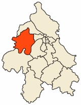
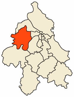
in 2003. Surčin municipality has 38,695 residents while Surčin town itself has 14,292. The most important feature is the Belgrade Nikola Tesla Airport
Belgrade Nikola Tesla Airport
Belgrade Nikola Tesla Airport is Serbia's busiest airport, also known as Surčin , after a nearby Belgrade district.Named after Nikola Tesla, the airport is situated west, of central Belgrade, in the Municipality of Surčin, surrounded by Syrmia's fertile lowlands...
, located just a few kilometers west of the town.
Geography
Surčin is located in the eastern SyrmiaSyrmia
Syrmia is a fertile region of the Pannonian Plain in Europe, between the Danube and Sava rivers. It is divided between Serbia in the east and Croatia in the west....
region, 20 kilometers west of downtown Belgrade
Belgrade
Belgrade is the capital and largest city of Serbia. It is located at the confluence of the Sava and Danube rivers, where the Pannonian Plain meets the Balkans. According to official results of Census 2011, the city has a population of 1,639,121. It is one of the 15 largest cities in Europe...
. It borders the municipalities of Zemun (north) and Novi Beograd
Novi Beograd
Novi Beograd or New Belgrade is the most populous municipality that constitutes the City of Belgrade, the capital of Serbia. It is a planned city, built in 1947 on the left bank of the Sava river which was previously an uninhabited area, opposite of the old Belgrade...
(east). Entire western border of the municipality is the administrative border of the province of Vojvodina
Vojvodina
Vojvodina, officially called Autonomous Province of Vojvodina is an autonomous province of Serbia. Its capital and largest city is Novi Sad...
while the Sava river formes the border to the municipalities of Čukarica
Cukarica
Čukarica is an urban neighborhood and one of the 17 municipalities than constitute the City of Belgrade, the capital of Serbia.- Neighbourhoods :...
(south-east) and Obrenovac
Obrenovac
Obrenovac is a town and municipality located in Serbia at 44°40′ North, 20°13′ East. Its name stems from last name "Obrenović" which in turn stems from name "Obren" in Serbian language. In 2003 the municipality has total population of 75,949...
(south).
The area of the municipality is flat and marshy as the entire southern section belongs to the floodplain
Floodplain
A floodplain, or flood plain, is a flat or nearly flat land adjacent a stream or river that stretches from the banks of its channel to the base of the enclosing valley walls and experiences flooding during periods of high discharge...
of the Sava. Numerous smaller streams (mostly channeled) flow through the municipality, most notably the Galovica and Jarčina
Jarcina
The Jarčina is a system of rivers and canals in the Srem region of Vojvodina province of Serbia with a total length of 53 km, which empties into the Sava river. The system includes the Međeš river-Jarčina Galovica canal-Progarska Jarčina course.- Međeš :The upper section of the system is the...
.
Other distinct geographical features are the ponds of Fenek and Živača, a large woody area od Bojčin (Serbian: Bojčinska šuma) and
Progarska ada, one of the largest islands in the Sava.
Surčin lies just south of the Belgrade–Zagreb highway
E70 in Serbia
The part of the European route E70 in Serbia spans approximately . It crosses the country from east to west, starting at Batrovci border crossing with Croatia and ending with Vatin border crossing with Romania...
, on the Belgrade beltway which, when finished in 2011, will bypass the heavy traffic from the Belgrade's urban core to the city's southern outskirts (for now, it is the only case among European capitals that highway passes right through the city). The Syrmian section of the beltway (which separates from the highway at Dobanovci, then goes Surčin–Jakovo–Ostružnica
Ostružnica
Ostružnica is a suburban settlement of Belgrade, the capital of Serbia. It is located in the municipality of Čukarica....
) is already built and operational. An internal Belgrade's freight railway goes parallel to the beltway.
Settlements
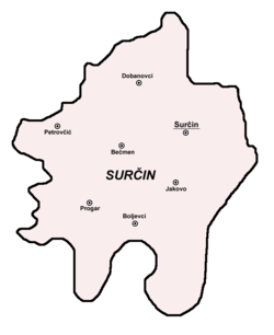
Urban (towns):- Surčin
- DobanovciDobanovciDobanovci is an suburban neighborhood of Belgrade, the capital of Serbia. It is located in Belgrade's municipality of Surčin....
Rural (villages):
- BoljevciBoljevciBoljevci is a suburban settlement of Belgrade, the capital of Serbia. It is located in Belgrade's municipality of Surčin.- Location :...
- BečmenBecmenBečmen is an suburban settlement of Belgrade, the capital of Serbia. It is located in Belgrade's municipality of Surčin.- Location :...
(with the hamlet of Ključ) - ProgarProgarProgar is a suburban neighborhood of Belgrade, the capital of Serbia. It is located in Belgrade's municipality of Surčin.- Location :...
- PetrovčićPetrovcicPetrovčić is a suburban settlement of Belgrade, the capital of Serbia. It is located in Belgrade's municipality of Surčin.- Location :...
- JakovoJakovo (village)Jakovo is an suburban neighborhood of Belgrade, the capital of Serbia. It is located in Belgrade's municipality of Surčin.- Location :...
(with the salaš Stremen)
Demographics
Surčin and the majority of the settlements in the municipality are growing fast. Though in the past, it had no urban connection with Belgrade on the east (that is, Novi BeogradNovi Beograd
Novi Beograd or New Belgrade is the most populous municipality that constitutes the City of Belgrade, the capital of Serbia. It is a planned city, built in 1947 on the left bank of the Sava river which was previously an uninhabited area, opposite of the old Belgrade...
's westernmost neighborhood of Ledine
Ledine
Ledine is an urban neighborhood of Belgrade, the capital of Serbia. It is located in Belgrade's municipality of Novi Beograd....
through which it is connected to the city), an urban zone is developed along that road, turning Belgrade and Surčin into one continuous built-up area. Similar process develops on all sides of Surčin which, with the growth of population, grows into one urban area with Dobanovci
Dobanovci
Dobanovci is an suburban neighborhood of Belgrade, the capital of Serbia. It is located in Belgrade's municipality of Surčin....
(north), Jakovo (south) and Bečmen
Becmen
Bečmen is an suburban settlement of Belgrade, the capital of Serbia. It is located in Belgrade's municipality of Surčin.- Location :...
(west).
Population of the town of Surčin according to the official censuses:
- 1921 - 3,250
- 1931 - 3,502
- 1961 - 6,160
- 1971 - 10,550
- 1981 - 12,575
- 1991 - 11,826
- 2002 - 14,292
Ethnic structure of the town (2002 census):
- SerbsSerbsThe Serbs are a South Slavic ethnic group of the Balkans and southern Central Europe. Serbs are located mainly in Serbia, Montenegro and Bosnia and Herzegovina, and form a sizable minority in Croatia, the Republic of Macedonia and Slovenia. Likewise, Serbs are an officially recognized minority in...
= 12,358 (86.47%) - Roma = 702 (4.91%)
- CroatsCroatsCroats are a South Slavic ethnic group mostly living in Croatia, Bosnia and Herzegovina and nearby countries. There are around 4 million Croats living inside Croatia and up to 4.5 million throughout the rest of the world. Responding to political, social and economic pressure, many Croats have...
= 377 (2.64%) - YugoslavsYugoslavsYugoslavs is a national designation used by a minority of South Slavs across the countries of the former Yugoslavia and in the diaspora...
= 79 (0.55%) - Montenegrins = 75 (0.53%)
Ethnic structure of the municipality (2002 census)
- SerbsSerbsThe Serbs are a South Slavic ethnic group of the Balkans and southern Central Europe. Serbs are located mainly in Serbia, Montenegro and Bosnia and Herzegovina, and form a sizable minority in Croatia, the Republic of Macedonia and Slovenia. Likewise, Serbs are an officially recognized minority in...
= 34,055 (88.01%) - SlovaksSlovaksThe Slovaks, Slovak people, or Slovakians are a West Slavic people that primarily inhabit Slovakia and speak the Slovak language, which is closely related to the Czech language.Most Slovaks today live within the borders of the independent Slovakia...
= 1,417 (3.66%) - Roma = 922 (2.38%)
- CroatsCroatsCroats are a South Slavic ethnic group mostly living in Croatia, Bosnia and Herzegovina and nearby countries. There are around 4 million Croats living inside Croatia and up to 4.5 million throughout the rest of the world. Responding to political, social and economic pressure, many Croats have...
= 460 (1.19%) - YugoslavsYugoslavsYugoslavs is a national designation used by a minority of South Slavs across the countries of the former Yugoslavia and in the diaspora...
= 223 (0.58%)
All settlements in the municipality have an ethnic Serb majority.
History
The area of the town was settled through the most of the early human history. Being an old settlement, findings from prehistoric times are quite common. So far, it is established that a previous settlements existed in the neolithicNeolithic
The Neolithic Age, Era, or Period, or New Stone Age, was a period in the development of human technology, beginning about 9500 BC in some parts of the Middle East, and later in other parts of the world. It is traditionally considered as the last part of the Stone Age...
, bronze age
Bronze Age
The Bronze Age is a period characterized by the use of copper and its alloy bronze as the chief hard materials in the manufacture of some implements and weapons. Chronologically, it stands between the Stone Age and Iron Age...
, stone age
Stone Age
The Stone Age is a broad prehistoric period, lasting about 2.5 million years , during which humans and their predecessor species in the genus Homo, as well as the earlier partly contemporary genera Australopithecus and Paranthropus, widely used exclusively stone as their hard material in the...
and Roman era.
In period 1991 to 2002, population of the municipality grew from 35,591 to 38,695. Majority of that growth came from the refugees from Yugoslav Wars
Yugoslav wars
The Yugoslav Wars were a series of wars, fought throughout the former Yugoslavia between 1991 and 1995. The wars were complex: characterized by bitter ethnic conflicts among the peoples of the former Yugoslavia, mostly between Serbs on the one side and Croats and Bosniaks on the other; but also...
(mostly Croatia
Croatia
Croatia , officially the Republic of Croatia , is a unitary democratic parliamentary republic in Europe at the crossroads of the Mitteleuropa, the Balkans, and the Mediterranean. Its capital and largest city is Zagreb. The country is divided into 20 counties and the city of Zagreb. Croatia covers ...
and Bosnia and Herzegovina
Bosnia and Herzegovina
Bosnia and Herzegovina , sometimes called Bosnia-Herzegovina or simply Bosnia, is a country in Southern Europe, on the Balkan Peninsula. Bordered by Croatia to the north, west and south, Serbia to the east, and Montenegro to the southeast, Bosnia and Herzegovina is almost landlocked, except for the...
). Since many of the refugees were integrated into the Serbian citizenship after 2002, it is to be expected the official number of population is much higher now.
Surčin was the seat of its own municipality until 1965 when it was annexed to the municipality of Zemun (prior to that, municipalities of Boljevci and Dobanovci were annexed to the municipality of Surčin). A movement for splitting from Zemun was very vocal since the 1990s and even though it did not fulfil some of the conditions required by the Belgrade City Statute for creation of new municipality (mainly, the population of over 50,000), Belgrade City assembly voted to detach Surčin from Zemun (officially on November 24, 2003) but the newly formed municipality remained under the administration of the municipality of Zemun until next municipal elections and finally got its own administration on November 3, 2004. However, municipal administration and the overall political situation in Surčin is highy unstable ever since.
President of the local community of Surčin:
- November 24, 2003 - November 3, 2004: Vojislav Janošević (b. 1946) (Democratic PartyDemocratic Party (Serbia)The Democratic Party is a political party in Serbia. It is described as a social liberal or social democratic party.-Pre-war history:The Democratic Party was established on 16 February 1919 from unification of Sarajevo parties independent radicals, progressives, liberals and the Serbian part of...
)
Presidents of the municipality:
- November 3, 2004 - November 24, 2005: Rajko Matović (b. 1960) (Serbian Radical PartySerbian Radical PartyThe Serbian Radical Party is a far-right Serbian nationalist political party in Serbia, founded in 1991. Currently the second-largest party in the Serbian National Assembly, it has branches in three of the nations that currently border Serbia – all former federal republics of Yugoslavia...
) - August 13, 2004 - November 24, 2005: Vladimir Aleksandrov (b. 1940) (former Serbian Radical Party; not confirmed by the Ministry for the local self-rule)
- November 24, 2005 - (present): Vojislav Janošević (Democratic Party)
Economy
The majority of population is into the agriculture. Extensive farms for the pig breeding are located in Surčin itself while in the smaller settlements the production is mostly for the Belgrade's market ("suburban agriculture" - fruits, early vegetables, etc.).The most important facility is the Belgrade Nikola Tesla airport, opened on April 28, 1962, instead of the old one in Bežanija
Bežanija
Bežanija is an urban neighborhood of Belgrade, the capital of Serbia. It is located in Belgrade's municipality of Novi Beograd.- Location :...
. The new and modern airport put the small village on the map. The aeronautics museum is also located in the airport's complex.
See also
- List of cities in Serbia
- Subdivisions of BelgradeSubdivisions of BelgradeThe city of Belgrade is divided into 17 municipalities.Most of the municipalities are situated on the southern side of the Danube and Sava rivers, in the Šumadija region...
- List of Belgrade neighborhoods and suburbs

