

Sunset Hill, Spokane, Washington
Encyclopedia
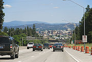
Sunset Hill is a neighborhood located west of downtown Spokane, Washington
, and just east of the West Plains. Sunset Hill is a region with a mixture of poorly-zoned areas, subdivisions, and old neighborhoods. Aside from being split in half by I-90 and the Sunset Highway, Sunset Hill sees little traffic due to the lack of thru-streets and limited exits to the arterials.
 North-side Sunset Hill homes were built in the 60's and early 70's. Upper level South-side Sunset Hill homes were built from 1970,
to the mid-80's. Both have subdivisons with many Frank Lloyd Wright
style homes as well as traditional homes that have been built in the adjoining areas since 2001. Many homes on both sides of Sunset Hill on the higher levels, have spectacular views of the city and are up to 500 ft higher in elevation than downtown Spokane.
descends into the Spokane Valley and Latah Valley. Most of the Plateau slopes downwards towards the Columbia River
to the South and West of Sunset Hill. Due to Latah Creek
and the Spokane River
cutting through the plateau, Sunset Hill slopes downward towards the East, losing 500 feet of elevation. Along most of the east side of the hill the drop is rather abrupt, cut thru the basalt by the rivers Spokane and Latah. Two creeks flow down the hill, allowing for a more gentle slope. Garden Springs Creek begins atop the hill and flows down through the Finch Arboretum
, creek is straddled by the two main thoroughfares going up the hill, I-90 on the South and Sunset Highway on the North. Further North, Indian Canyon creek cuts a deep and compact canyon into the basalt hillside on its way past Indian Canyon Golf Course before reaching Latah Creek at its confluence with the Spokane River. North of Indian Canyon lie vast cemeteries and Palisades Park, a large nature reserve along the top of the hill.
Sunset Hill is divided into two of the city's 27 official neighborhoods. North of I-90 is the West Hills Neighborhood while to the South is the Thorpe/Grandview Neighborhood. Latah Creek is the eastern boundary of the hill, though the lower part of its terraced valley is technically in the Latah Valley Neighborhood also known as Vinegar Flats. U.S. Route 195
and the Burlington Northern railroad tracks serve as the official Eastern boundary of the Neighborhood south of I-90.
Spokane, Washington
Spokane is a city located in the Northwestern United States in the state of Washington. It is the largest city of Spokane County of which it is also the county seat, and the metropolitan center of the Inland Northwest region...
, and just east of the West Plains. Sunset Hill is a region with a mixture of poorly-zoned areas, subdivisions, and old neighborhoods. Aside from being split in half by I-90 and the Sunset Highway, Sunset Hill sees little traffic due to the lack of thru-streets and limited exits to the arterials.
to the mid-80's. Both have subdivisons with many Frank Lloyd Wright
Frank Lloyd Wright
Frank Lloyd Wright was an American architect, interior designer, writer and educator, who designed more than 1,000 structures and completed 500 works. Wright believed in designing structures which were in harmony with humanity and its environment, a philosophy he called organic architecture...
style homes as well as traditional homes that have been built in the adjoining areas since 2001. Many homes on both sides of Sunset Hill on the higher levels, have spectacular views of the city and are up to 500 ft higher in elevation than downtown Spokane.
Geography
Sunset Hill is located where the Columbia PlateauColumbia Plateau
The Columbia Plateau is a geologic and geographic region that lies across parts of the U.S. states of Washington, Oregon, and Idaho. It is a wide flood basalt plateau between the Cascade Range and the Rocky Mountains, cut through by the Columbia River...
descends into the Spokane Valley and Latah Valley. Most of the Plateau slopes downwards towards the Columbia River
Columbia River
The Columbia River is the largest river in the Pacific Northwest region of North America. The river rises in the Rocky Mountains of British Columbia, Canada, flows northwest and then south into the U.S. state of Washington, then turns west to form most of the border between Washington and the state...
to the South and West of Sunset Hill. Due to Latah Creek
Latah Creek
Latah Creek, also known as Hangman Creek, is a large stream in eastern Washington and north central Idaho in the United States. The creek flows northwest from the Rocky Mountains to Spokane, where it empties into the Spokane River...
and the Spokane River
Spokane River
The Spokane River is a tributary of the Columbia River, approximately long, in northern Idaho and eastern Washington in the United States. It drains a low mountainous area east of the Columbia, passing through the city of Spokane, Washington.-Description:...
cutting through the plateau, Sunset Hill slopes downward towards the East, losing 500 feet of elevation. Along most of the east side of the hill the drop is rather abrupt, cut thru the basalt by the rivers Spokane and Latah. Two creeks flow down the hill, allowing for a more gentle slope. Garden Springs Creek begins atop the hill and flows down through the Finch Arboretum
John A. Finch Arboretum
John A. Finch Arboretum is a public arboretum located at West 3404 Woodland Boulevard, Spokane, Washington, USA on Sunset Hill. It is open daily without charge....
, creek is straddled by the two main thoroughfares going up the hill, I-90 on the South and Sunset Highway on the North. Further North, Indian Canyon creek cuts a deep and compact canyon into the basalt hillside on its way past Indian Canyon Golf Course before reaching Latah Creek at its confluence with the Spokane River. North of Indian Canyon lie vast cemeteries and Palisades Park, a large nature reserve along the top of the hill.
Sunset Hill is divided into two of the city's 27 official neighborhoods. North of I-90 is the West Hills Neighborhood while to the South is the Thorpe/Grandview Neighborhood. Latah Creek is the eastern boundary of the hill, though the lower part of its terraced valley is technically in the Latah Valley Neighborhood also known as Vinegar Flats. U.S. Route 195
U.S. Route 195
U.S. Route 195 is a north–south U.S. Route serving the southeastern area of Washington. One of the oldest designations in the U.S. Highway system, it was created in the original 1926 plan. The highway passes two major universities, Washington State University in Pullman, and the University...
and the Burlington Northern railroad tracks serve as the official Eastern boundary of the Neighborhood south of I-90.