
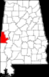
Sumter County, Alabama
Encyclopedia
Sumter County is a county
of the U.S. state
of Alabama
.
Its name is in honor of General Thomas Sumter
of South Carolina
. As of 2010, the population was 13,763. Its county seat
is Livingston
.
Nation, which was made up of four main villages. The first settlers in Sumter County were French explorers who had come north from Mobile
. They built and settled at Fort Tombecbe
e, near the modern-day town of Epes. In 1830, with the Treaty of Dancing Rabbit Creek
, the Choctaw Indians ceded the land that is now Sumter County to the government.
of 2000, there were 14,798 people, 5,708 households, and 3,664 families residing in the county. The population density
was 16 people per square mile (6/km2). There were 6,953 housing units at an average density of 8 per square mile (3/km2). The racial makeup of the county was 25.92% White
, 73.17% Black
or African American
, 0.09% Native American
, 0.10% Asian
, 0.01% Pacific Islander
, 0.18% from other races
, and 0.52% from two or more races. Nearly 1.12% of the population were Hispanic
or Latino
of any race.
There were 5,708 households out of which 31.90% had children under the age of 18 living with them, 36.70% were married couples
living together, 23.50% had a female householder with no husband present, and 35.80% were non-families. Nearly 31.20% of all households were made up of individuals, and 12.30% had someone living alone who was 65 years of age or older. The average household size was 2.55, and the average family size was 3.26.
In the county, the population was spread out with 29.10% under the age of 18, 12.20% from 18 to 24, 25.30% from 25 to 44, 19.50% from 45 to 64, and 13.90% who were 65 years of age or older. The median age was 32 years. For every 100 females, there were 84.90 males. For every 100 females age 18 and over, there were 78.20 males.
The median income for a household in the county was $18,911, and the median income for a family was $23,176. Males had a median income of $28,059 versus $17,574 for females. The per capita income
for the county was $11,491. About 32.90% of families and 38.70% of the population were below the poverty line, including 47.40% of those under age 18 and 36.10% of those age 65 or over.
region of central Alabama. The region has suffered significant economic depression in recent years. But in April 2008, United States Steel announced plans to build at $150 million alloy plant near the community of Epes about 50 miles (80.5 km) southwest of Tuscaloosa, Alabama
. The plant will require 250 workers to construct in a town of only 206. Up to 235 full time jobs will be created when completed with jobs paying about $50 thousand annually. The state of Alabama offered $28 million in incentives to get the plant located in Sumter County. The plant will make use of a new technology that produces a carbon alloy for use in steel making at the U.S. Steel plant in Fairfield, Alabama
near Birmingham
.
At the time of the announcement, the unemployment rate in Sumter County was 6.1 percent.
Outdoor Sculpture Exhibition and the Coleman Center for the Arts.
County (United States)
In the United States, a county is a geographic subdivision of a state , usually assigned some governmental authority. The term "county" is used in 48 of the 50 states; Louisiana is divided into parishes and Alaska into boroughs. Parishes and boroughs are called "county-equivalents" by the U.S...
of the U.S. state
U.S. state
A U.S. state is any one of the 50 federated states of the United States of America that share sovereignty with the federal government. Because of this shared sovereignty, an American is a citizen both of the federal entity and of his or her state of domicile. Four states use the official title of...
of Alabama
Alabama
Alabama is a state located in the southeastern region of the United States. It is bordered by Tennessee to the north, Georgia to the east, Florida and the Gulf of Mexico to the south, and Mississippi to the west. Alabama ranks 30th in total land area and ranks second in the size of its inland...
.
Its name is in honor of General Thomas Sumter
Thomas Sumter
Thomas Sumter nicknamed the "Carolina Gamecock" , was a hero of the American Revolution and went on to become a longtime member of the Congress of the United States.-Early life:Thomas Sumter was born near Charlottesville in Hanover County, Virginia in 1734...
of South Carolina
South Carolina
South Carolina is a state in the Deep South of the United States that borders Georgia to the south, North Carolina to the north, and the Atlantic Ocean to the east. Originally part of the Province of Carolina, the Province of South Carolina was one of the 13 colonies that declared independence...
. As of 2010, the population was 13,763. Its county seat
County seat
A county seat is an administrative center, or seat of government, for a county or civil parish. The term is primarily used in the United States....
is Livingston
Livingston, Alabama
Livingston is a city in Sumter County, Alabama, United States. At the 2000 census the population was 3,297. The city is the county seat of Sumter County.-Geography:Livingston is located at .According to the U.S...
.
History
Sumter County was established on December 18, 1832. From 1797 to 1832, Sumter County was part of the ChoctawChoctaw
The Choctaw are a Native American people originally from the Southeastern United States...
Nation, which was made up of four main villages. The first settlers in Sumter County were French explorers who had come north from Mobile
Mobile, Alabama
Mobile is the third most populous city in the Southern US state of Alabama and is the county seat of Mobile County. It is located on the Mobile River and the central Gulf Coast of the United States. The population within the city limits was 195,111 during the 2010 census. It is the largest...
. They built and settled at Fort Tombecbe
Fort Tombecbe
Fort Tombecbe , also spelled Tombecbee and Tombeché, was a stockade fort located on the Tombigbee River near the border of French Louisiana, in what is now Sumter County, Alabama. It was constructed under the leadership of Jean-Baptiste Le Moyne, Sieur de Bienville in 1736-37 as trading post about...
e, near the modern-day town of Epes. In 1830, with the Treaty of Dancing Rabbit Creek
Treaty of Dancing Rabbit Creek
The Treaty of Dancing Rabbit Creek was a treaty signed on September 27, 1830 between the Choctaw and the United States Government. This was the first removal treaty carried into effect under the Indian Removal Act...
, the Choctaw Indians ceded the land that is now Sumter County to the government.
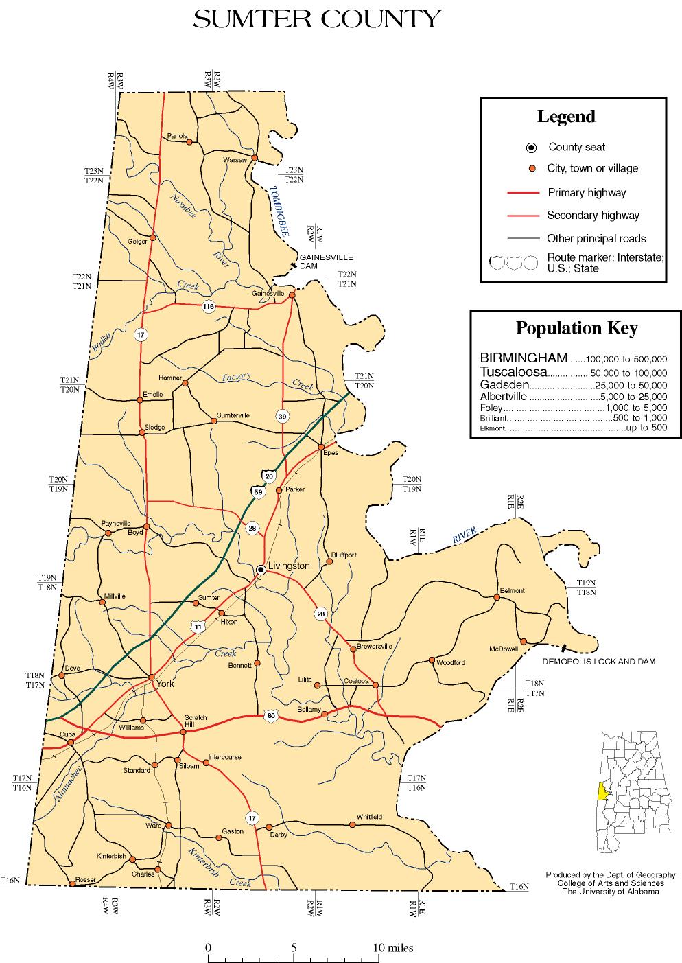
Geography
According to the 2000 census, the county has a total area of 913.3 square miles (2,365.4 km²), of which 904.94 square miles (2,343.8 km²) (or 99.08%) is land and 8.37 square miles (21.7 km²) (or 0.92%) is water.Major highways
.svg.png)
 Interstate 20Interstate 20Interstate 20 is a major east–west Interstate Highway in the Southern United States. I‑20 runs 1,535 miles from near Kent, Texas, at Interstate 10 to Florence, South Carolina, at Interstate 95...
Interstate 20Interstate 20Interstate 20 is a major east–west Interstate Highway in the Southern United States. I‑20 runs 1,535 miles from near Kent, Texas, at Interstate 10 to Florence, South Carolina, at Interstate 95...
/Interstate 59Interstate 59Interstate 59 is an Interstate Highway in the southern United States. Its southern terminus is near Slidell, Louisiana, a suburb of New Orleans, at an intersection with Interstate 10 and Interstate 12, its northern terminus is at Wildwood, Georgia, at an intersection with Interstate 24.The road's... U.S. Highway 11
 U.S. Highway 80
 State Route 17
 State Route 28
 State Route 39
Adjacent counties
- Pickens CountyPickens County, AlabamaPickens County is a county of the U.S. state of Alabama. As of 2010, the population was 19,746. Its county seat is Carrollton, and it is a prohibition, or dry county.-History:...
(north) - Greene CountyGreene County, AlabamaGreene County is the least populous county in the U.S. state of Alabama. Its name is in honor of Revolutionary War General Nathanael Greene of Rhode Island. As of 2010 the population was 9,045...
(northeast) - Marengo CountyMarengo County, AlabamaMarengo County is a county of the U.S. state of Alabama. It is named in honor of a battlefield near Turin, Italy, where the French defeated the Austrians on June 14, 1800. As of 2010 the population was 21,027...
(southeast) - Choctaw CountyChoctaw County, AlabamaChoctaw County is a county of the U.S. state of Alabama. It was established on December 29, 1847 and named for the Choctaw tribe of American Indians. As of 2010 the population was 13,859. The county seat is Butler.- History :...
(south) - Lauderdale County, MississippiLauderdale County, Mississippi-Demographics:As of the census of 2000, there were 78,161 people, 29,990 households, and 20,573 families residing in the county. The population density was 111 people per square mile . There were 33,418 housing units at an average density of 48 per square mile...
(southwest) - Kemper County, MississippiKemper County, Mississippi-Demographics:As of the census of 2000, there were 10,453 people, 3,909 households, and 2,787 families residing in the county. The population density was 14 people per square mile . There were 4,533 housing units at an average density of 6 per square mile...
(west) - Noxubee County, MississippiNoxubee County, Mississippi-Demographics:As of the census of 2000, there were 12,548 people, 4,470 households, and 3,222 families residing in the county. The population density was 18 people per square mile . There were 5,228 housing units at an average density of 8 per square mile...
(northwest)
Demographics
As of the censusCensus
A census is the procedure of systematically acquiring and recording information about the members of a given population. It is a regularly occurring and official count of a particular population. The term is used mostly in connection with national population and housing censuses; other common...
of 2000, there were 14,798 people, 5,708 households, and 3,664 families residing in the county. The population density
Population density
Population density is a measurement of population per unit area or unit volume. It is frequently applied to living organisms, and particularly to humans...
was 16 people per square mile (6/km2). There were 6,953 housing units at an average density of 8 per square mile (3/km2). The racial makeup of the county was 25.92% White
Race (United States Census)
Race and ethnicity in the United States Census, as defined by the Federal Office of Management and Budget and the United States Census Bureau, are self-identification data items in which residents choose the race or races with which they most closely identify, and indicate whether or not they are...
, 73.17% Black
Race (United States Census)
Race and ethnicity in the United States Census, as defined by the Federal Office of Management and Budget and the United States Census Bureau, are self-identification data items in which residents choose the race or races with which they most closely identify, and indicate whether or not they are...
or African American
Race (United States Census)
Race and ethnicity in the United States Census, as defined by the Federal Office of Management and Budget and the United States Census Bureau, are self-identification data items in which residents choose the race or races with which they most closely identify, and indicate whether or not they are...
, 0.09% Native American
Race (United States Census)
Race and ethnicity in the United States Census, as defined by the Federal Office of Management and Budget and the United States Census Bureau, are self-identification data items in which residents choose the race or races with which they most closely identify, and indicate whether or not they are...
, 0.10% Asian
Race (United States Census)
Race and ethnicity in the United States Census, as defined by the Federal Office of Management and Budget and the United States Census Bureau, are self-identification data items in which residents choose the race or races with which they most closely identify, and indicate whether or not they are...
, 0.01% Pacific Islander
Race (United States Census)
Race and ethnicity in the United States Census, as defined by the Federal Office of Management and Budget and the United States Census Bureau, are self-identification data items in which residents choose the race or races with which they most closely identify, and indicate whether or not they are...
, 0.18% from other races
Race (United States Census)
Race and ethnicity in the United States Census, as defined by the Federal Office of Management and Budget and the United States Census Bureau, are self-identification data items in which residents choose the race or races with which they most closely identify, and indicate whether or not they are...
, and 0.52% from two or more races. Nearly 1.12% of the population were Hispanic
Race (United States Census)
Race and ethnicity in the United States Census, as defined by the Federal Office of Management and Budget and the United States Census Bureau, are self-identification data items in which residents choose the race or races with which they most closely identify, and indicate whether or not they are...
or Latino
Race (United States Census)
Race and ethnicity in the United States Census, as defined by the Federal Office of Management and Budget and the United States Census Bureau, are self-identification data items in which residents choose the race or races with which they most closely identify, and indicate whether or not they are...
of any race.
There were 5,708 households out of which 31.90% had children under the age of 18 living with them, 36.70% were married couples
Marriage
Marriage is a social union or legal contract between people that creates kinship. It is an institution in which interpersonal relationships, usually intimate and sexual, are acknowledged in a variety of ways, depending on the culture or subculture in which it is found...
living together, 23.50% had a female householder with no husband present, and 35.80% were non-families. Nearly 31.20% of all households were made up of individuals, and 12.30% had someone living alone who was 65 years of age or older. The average household size was 2.55, and the average family size was 3.26.
In the county, the population was spread out with 29.10% under the age of 18, 12.20% from 18 to 24, 25.30% from 25 to 44, 19.50% from 45 to 64, and 13.90% who were 65 years of age or older. The median age was 32 years. For every 100 females, there were 84.90 males. For every 100 females age 18 and over, there were 78.20 males.
The median income for a household in the county was $18,911, and the median income for a family was $23,176. Males had a median income of $28,059 versus $17,574 for females. The per capita income
Per capita income
Per capita income or income per person is a measure of mean income within an economic aggregate, such as a country or city. It is calculated by taking a measure of all sources of income in the aggregate and dividing it by the total population...
for the county was $11,491. About 32.90% of families and 38.70% of the population were below the poverty line, including 47.40% of those under age 18 and 36.10% of those age 65 or over.
Economy
Sumter County is part of the so-called Black BeltBlack Belt (region of Alabama)
The Black Belt is a region of the U.S. state of Alabama, and part of the larger Black Belt Region of the Southern United States, which stretches from Texas to Maryland. The term originally referred to the region underlain by a thin layer of rich, black topsoil developed atop the chalk of the Selma...
region of central Alabama. The region has suffered significant economic depression in recent years. But in April 2008, United States Steel announced plans to build at $150 million alloy plant near the community of Epes about 50 miles (80.5 km) southwest of Tuscaloosa, Alabama
Tuscaloosa, Alabama
Tuscaloosa is a city in and the seat of Tuscaloosa County in west central Alabama . Located on the Black Warrior River, it is the fifth-largest city in Alabama, with a population of 90,468 in 2010...
. The plant will require 250 workers to construct in a town of only 206. Up to 235 full time jobs will be created when completed with jobs paying about $50 thousand annually. The state of Alabama offered $28 million in incentives to get the plant located in Sumter County. The plant will make use of a new technology that produces a carbon alloy for use in steel making at the U.S. Steel plant in Fairfield, Alabama
Fairfield, Alabama
Fairfield is a city in Jefferson County, Alabama, United States. It is part of the Birmingham–Hoover Metropolitan Area. The population was 12,381 at the 2000 census. As of 2006, the Census estimates the population to be 11,547.-History:...
near Birmingham
Birmingham, Alabama
Birmingham is the largest city in Alabama. The city is the county seat of Jefferson County. According to the 2010 United States Census, Birmingham had a population of 212,237. The Birmingham-Hoover Metropolitan Area, in estimate by the U.S...
.
At the time of the announcement, the unemployment rate in Sumter County was 6.1 percent.
Cities and towns
- CubaCuba, AlabamaCuba is a town in Sumter County, Alabama, United States. At the 2000 census the population was 363.-Geography:Cuba is located at ....
- EmelleEmelle, AlabamaEmelle is a town in Sumter County, Alabama, United States. It was named after the daughters of the man who donated the land for the town. The town was started in the 19th century but not incorporated until the 1980s. The daughters of the man who donated were named Emma Dial and Ella Dial, so he...
- EpesEpes, AlabamaEpes is a town in Sumter County, Alabama, United States. At the 2000 census the population was 206.-Geography:Epes is located at .According to the U.S. Census Bureau, the town has a total area of , all of it land.-Demographics:...
- GainesvilleGainesville, AlabamaGainesville is a town in Sumter County, Alabama, United States. At the 2000 census the population was 220.-Geography:Gainesville is located at .According to the U.S. Census Bureau, the town has a total area of , all of it land....
- GeigerGeiger, AlabamaGeiger is a town in Sumter County, Alabama, United States. At the 2000 census the population was 161.-Geography:Geiger is located at .According to the U.S. Census Bureau, the town has a total area of , all of it land....
- LivingstonLivingston, AlabamaLivingston is a city in Sumter County, Alabama, United States. At the 2000 census the population was 3,297. The city is the county seat of Sumter County.-Geography:Livingston is located at .According to the U.S...
- YorkYork, AlabamaYork is a city in Sumter County, Alabama, United States. At the 2000 census the population was 2,854.-Geography:York is located at .According to the U.S. Census Bureau, the city has a total area of , of which, of it is land and of it is water....
- PanolaPanola, Sumter County, AlabamaPanola is an unincorporated community in Sumter County, Alabama, United States. Panola is north-northeast of Geiger. Panola has a post office with ZIP code 35477....
- Payneville
Places of interest
Sumter County is home to the University of West AlabamaUniversity of West Alabama
The University of West Alabama is a public university located in Livingston, Alabama, United States. It is currently on probation with its regional accrediting body....
Outdoor Sculpture Exhibition and the Coleman Center for the Arts.
See also
- National Register of Historic Places listings in Sumter County, Alabama
- Properties on the Alabama Register of Landmarks and Heritage in Sumter County, Alabama
External links
- http://www.angelfire.com/al2/bcampbell/sumteral.html.
- Sumter County map of roads/towns (map © 2007 Univ. of AlabamaUniversity of AlabamaThe University of Alabama is a public coeducational university located in Tuscaloosa, Alabama, United States....
).