
Summerhill, Dumfries
Encyclopedia
Summerhill in Dumfries
is a post war residential suburb on the West side of the town. It is located on the Maxwelltown
side of the River Nith
that runs through Dumfries. Summerhill is bounded by Terregles Road to the North, the streets that branch off Ellisland Drive to the East, the Dumfries and Galloway Golf Club to the South and West and also to the West by the disused Maxwelltown train station.
Most of the streets in Summerhill were named containing connotations associated with Scotland's national poet Robert Burns
. Burns lived in Dumfries for his last years and died there in 1796. Examples of the Burns influenced street names in Summerhill are Afton Drive, Armour Drive, Ballochmyle Terrace, Campbell Avenue, Doon Terrace, Ellisland Drive, Gilbert Circle, Glencairn Road, Mauchline Terrace and Mossgiel Avenue.
The housing capacity of Summerhill was increased in the 90s with the creation of 3 additional streets.
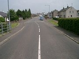
 As the name suggests Terregles Road forms part of the spoke from Dumfries leading to the village of Terregles
approximately 2 miles further West from Summerhill. When Summerhill housing estate was originally completed the visible marker connecting the urban area of Dumfries and the rural areas beyond was the hump back railway bridge on Terregles Road. In the 1990s the urban boundary moved further West with the development of a new housing estate beyond the bridge. Terregles Road was also home to the offices and yard of Haley's builders before Haley's demise.
The terraced houses on the council built Southern side of Terregles Road contain 4 bedroom gable end houses. As such the 4 bedroom houses were used by the council for housing the biggest families in Summerhill. The numbers of the 4 bedroom gable end houses are 3, 9, 11, 25, 27, 33, 35, 41, 43, 57, 59 and 65.
Terregles Road is a continuation of Terregles Street. Terregles Street is home to Palmerston Park
of Queen of the South F.C.
club in Dumfries on the Maxwelltown side of the River Nith. It is the area around the 2nd and 5th holes and the 6th tee on the course that partially hem in Summerhill. The 2nd and the 5th are the only par 5 holes of the 18 on the course. Golf Avenue is the longer and older of the 2 streets in Summerhill adjacent to the golf course. Golfers playing the par 4 6th are required to negotiate a burn (small stream) that runs most of the length of the hole. The burn eventually runs into the nearby Cargen Pow, a tributary of the Nith.
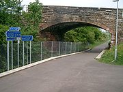 The line from Dumfries through Maxwelltown station on the periphery of Summerhill to Castle Douglas
and beyond was closed to passengers in the 1960s as part of the Beeching axe
. The line through the station was used for some years more to allow trains to carry chemical tankers to/from the ICI factory just outside Dumfries at Cargenbridge. Without passengers Maxwelltown station was redundant and so was closed. More recently the line has been closed completely and has been replaced with a cycle path.
Bus services 9 and 9A run between Dumfries town centre and Afton Drive in Summerhill. Bus service 373 between Dumfries and Shawhead runs along Terregles Road.
Laurieknowe school is adjacent to Dumfries prison. The prison is on Nelson Street accessed from Terregles Street. Neither the school nor the prison are in Summerhill.
The Community Centre located in Ballochmyle Terrace is also a major source of recreation for a number of residents in the area, mainly young people. This includes hosting "The Base" Youth group for young people ages 12-16 and the junior youth group for ages 5-11.
Thus the hostelries typically (but not exclusively) used by people from Summerhill based on the pubs' proximity between the suburb and the town centre are The Spread Eagle, The Salutation, The Globe Inn (not to be confused with The Globe Inn on Dumfries High Street associated with Robert Burns) and The Devorgilla Lounge. All four are in the Market Street area only separated from Dumfries town centre by the River Nith. However the nearest premises licensed to sell alcohol for consumption on site is the social club at Queen of the South's Palmerston Park.
until the club negotiated a move to Park Farm in 1953.
Dumfries
Dumfries is a market town and former royal burgh within the Dumfries and Galloway council area of Scotland. It is near the mouth of the River Nith into the Solway Firth. Dumfries was the county town of the former county of Dumfriesshire. Dumfries is nicknamed Queen of the South...
is a post war residential suburb on the West side of the town. It is located on the Maxwelltown
Maxwelltown
Maxwelltown was formerly a burgh of barony and police burgh in the county of Kirkcudbrightshire in south west Scotland. In 1929 Maxwelltown was merged with Dumfries....
side of the River Nith
River Nith
The River Nith is a river in South West Scotland.-Source, flow and mouth:The Nith rises in the Carsphairn hills of East Ayrshire, more precisely between Prickeny Hill and Enoch Hill, 7 km East of Dalmellington...
that runs through Dumfries. Summerhill is bounded by Terregles Road to the North, the streets that branch off Ellisland Drive to the East, the Dumfries and Galloway Golf Club to the South and West and also to the West by the disused Maxwelltown train station.
Housing
The suburb comprises primarily but not exclusively of a mixture of terraced houses and blocks of 3 storey flats.Most of the streets in Summerhill were named containing connotations associated with Scotland's national poet Robert Burns
Robert Burns
Robert Burns was a Scottish poet and a lyricist. He is widely regarded as the national poet of Scotland, and is celebrated worldwide...
. Burns lived in Dumfries for his last years and died there in 1796. Examples of the Burns influenced street names in Summerhill are Afton Drive, Armour Drive, Ballochmyle Terrace, Campbell Avenue, Doon Terrace, Ellisland Drive, Gilbert Circle, Glencairn Road, Mauchline Terrace and Mossgiel Avenue.
The housing capacity of Summerhill was increased in the 90s with the creation of 3 additional streets.
Terregles Road
Terregles
Terregles is a village and parish near Dumfries, in Dumfries and Galloway, Scotland. It lies in the former county of Kirkcudbrightshire.The name Terregles is said to be a corruption of Brythonic Tir-eglwys...
approximately 2 miles further West from Summerhill. When Summerhill housing estate was originally completed the visible marker connecting the urban area of Dumfries and the rural areas beyond was the hump back railway bridge on Terregles Road. In the 1990s the urban boundary moved further West with the development of a new housing estate beyond the bridge. Terregles Road was also home to the offices and yard of Haley's builders before Haley's demise.
The terraced houses on the council built Southern side of Terregles Road contain 4 bedroom gable end houses. As such the 4 bedroom houses were used by the council for housing the biggest families in Summerhill. The numbers of the 4 bedroom gable end houses are 3, 9, 11, 25, 27, 33, 35, 41, 43, 57, 59 and 65.
Terregles Road is a continuation of Terregles Street. Terregles Street is home to Palmerston Park
Palmerston Park
Palmerston Park is a multi-purpose stadium on Terregles Street in Dumfries, south west Scotland. The site of the ground was formerly a farm called Palmers Toun. This is on the Maxwelltown side of the River Nith in Dumfries. It is currently used mostly for football matches and is the home ground of...
of Queen of the South F.C.
Queen of the South F.C.
Queen of the South Football Club is a Scottish professional football club founded in 1919 and located in Dumfries. The club currently plays in the Scottish First Division, the second tier of Scottish football. They are officially nicknamed The Doonhamers, but usually referred to as Queens or QoS...
Boundary with Dumfries and Galloway Golf Club
The Dumfries and Galloway Golf Club is the only golfGolf
Golf is a precision club and ball sport, in which competing players use many types of clubs to hit balls into a series of holes on a golf course using the fewest number of strokes....
club in Dumfries on the Maxwelltown side of the River Nith. It is the area around the 2nd and 5th holes and the 6th tee on the course that partially hem in Summerhill. The 2nd and the 5th are the only par 5 holes of the 18 on the course. Golf Avenue is the longer and older of the 2 streets in Summerhill adjacent to the golf course. Golfers playing the par 4 6th are required to negotiate a burn (small stream) that runs most of the length of the hole. The burn eventually runs into the nearby Cargen Pow, a tributary of the Nith.
Transport
Castle Douglas
Castle Douglas , a town in the south of Scotland in Dumfries and Galloway, lies in the eastern part of Galloway known as the Stewartry, between the towns of Dalbeattie and Gatehouse of Fleet.-History:...
and beyond was closed to passengers in the 1960s as part of the Beeching axe
Beeching Axe
The Beeching Axe or the Beeching Cuts are informal names for the British Government's attempt in the 1960s to reduce the cost of running British Railways, the nationalised railway system in the United Kingdom. The name is that of the main author of The Reshaping of British Railways, Dr Richard...
. The line through the station was used for some years more to allow trains to carry chemical tankers to/from the ICI factory just outside Dumfries at Cargenbridge. Without passengers Maxwelltown station was redundant and so was closed. More recently the line has been closed completely and has been replaced with a cycle path.
Bus services 9 and 9A run between Dumfries town centre and Afton Drive in Summerhill. Bus service 373 between Dumfries and Shawhead runs along Terregles Road.
Schools
Summerhill is one of the suburbs in the catchment area for Laurieknowe primary school. Pupils from Summerhill would use the James Avenue entrance accessed from Terregles Street. The school to serve those in Summerhill desiring a catholic school education for their children is St Teresa's in the Lochside area of Dumfries.Laurieknowe school is adjacent to Dumfries prison. The prison is on Nelson Street accessed from Terregles Street. Neither the school nor the prison are in Summerhill.
Recreation
The council maintained grassed recreational field at the West End of Armour Drive and Golf Avenue was replaced with additional housing in the 90s. The new street was named McGeoch Drive. This leaves 2 grassed recreational fields; one at Doon Terrace that has suffered historically with poor drainage and one at Ballochmyle Terrace. A recent construction nas been a MUGA (Multi Use Games Area) on the grass at Ballochmyle Terrace.The Community Centre located in Ballochmyle Terrace is also a major source of recreation for a number of residents in the area, mainly young people. This includes hosting "The Base" Youth group for young people ages 12-16 and the junior youth group for ages 5-11.
Public houses and licensed bars
Summerhill was once home to a licensed bar named The Palmerston Hotel. The Palmerston survived a fire and was renamed on more than one occasion (e.g. Sliquors, The Driveway) before closing its doors for the last time in the 90s. Its grounds were then used to build additional housing on a newly created street called Simpson Gardens.Thus the hostelries typically (but not exclusively) used by people from Summerhill based on the pubs' proximity between the suburb and the town centre are The Spread Eagle, The Salutation, The Globe Inn (not to be confused with The Globe Inn on Dumfries High Street associated with Robert Burns) and The Devorgilla Lounge. All four are in the Market Street area only separated from Dumfries town centre by the River Nith. However the nearest premises licensed to sell alcohol for consumption on site is the social club at Queen of the South's Palmerston Park.
Dumfries Rugby Club
Summerhill was home to Dumfries Rugby ClubDumfries Rugby Club
Dumfries Rugby Club is a Scottish rugby union club based in Dumfries.The club recently adopted the name of Dumfries Saints to reflect the link to Saint Michael and the town crest which has always been used by the club. The 1st XV currently plays in Scottish Premiership Division 3.-History:The first...
until the club negotiated a move to Park Farm in 1953.