

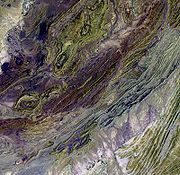
Sulaiman Mountains
Encyclopedia
Afghanistan
Afghanistan , officially the Islamic Republic of Afghanistan, is a landlocked country located in the centre of Asia, forming South Asia, Central Asia and the Middle East. With a population of about 29 million, it has an area of , making it the 42nd most populous and 41st largest nation in the world...
(Loya Paktia
Loya Paktia
Loya Paktia is historically a region of Afghanistan, comprising the modern Afghan provinces of Paktia, Paktika and Khost.Loya Paktia generally coincides with the Zadran Arc, depicting the range of the Pashtun Zadran tribe....
, Zabul
Zabul Province
Zabul is a historic province of Afghanistan. Zabul became an independent province from neighbouring Kandahar in 1963, with Qalat being named the provincial capital. It should not be confused with the city Zabol, on the Iranian side of the border with Afghanistan.- Political and security situation...
and Kandahar
Kandahar Province
Kandahar or Qandahar is one of the largest of the thirty-four provinces of Afghanistan. It is located in southern Afghanistan, between Helmand, Oruzgan and Zabul provinces. Its capital is the city of Kandahar, which is located on the Arghandab River. The province has a population of nearly...
regions) and northern Balochistan
Balochistan (Pakistan)
Balochistan is one of the four provinces or federating units of Pakistan. With an area of 134,051 mi2 or , it is the largest province of Pakistan, constituting approximately 44% of the total land mass of Pakistan. According to the 1998 population census, Balochistan had a population of...
province of Pakistan
Pakistan
Pakistan , officially the Islamic Republic of Pakistan is a sovereign state in South Asia. It has a coastline along the Arabian Sea and the Gulf of Oman in the south and is bordered by Afghanistan and Iran in the west, India in the east and China in the far northeast. In the north, Tajikistan...
. In Pakistan
Pakistan
Pakistan , officially the Islamic Republic of Pakistan is a sovereign state in South Asia. It has a coastline along the Arabian Sea and the Gulf of Oman in the south and is bordered by Afghanistan and Iran in the west, India in the east and China in the far northeast. In the north, Tajikistan...
, it forms the eastern edge of the Iranian plateau
Iranian plateau
The Iranian plateau, or Iranic plateau, is a geological formation in Southwest Asia. It is the part of the Eurasian Plate wedged between the Arabian and Indian plates, situated between the Zagros mountains to the west, the Caspian Sea and the Kopet Dag to the north, the Hormuz Strait and Persian...
where the Indus River
Indus River
The Indus River is a major river which flows through Pakistan. It also has courses through China and India.Originating in the Tibetan plateau of western China in the vicinity of Lake Mansarovar in Tibet Autonomous Region, the river runs a course through the Ladakh district of Jammu and Kashmir and...
separates it from the Asian Subcontient. Bordering the Sulaiman Range to the north are the arid highlands of the Hindu Kush
Hindu Kush
The Hindu Kush is an mountain range that stretches between central Afghanistan and northern Pakistan. The highest point in the Hindu Kush is Tirich Mir in the Chitral region of Khyber-Pakhtunkhwa, Pakistan.It is the westernmost extension of the Pamir Mountains, the Karakoram Range, and is a...
, with more than 50 percent of the lands there lying above 2,000 m
1 E3 m
To help compare different orders of magnitude this page lists lengths between 1 kilometre and 10 kilometres .Distances shorter than 1 kilometre-Conversions:1 kilometre is equal to:* 1,000 metres...
(6,500 feet). The highest peak of Sulaiman Mountains is Takht-e-Sulaiman
Takht-e-Sulaiman
For a site in West Azarbaijan, Iran known by the same name, see Takht-i-SuleimanFor a site located in Osh, Kyrgyzstan known by the same name, see Sulayman Mountain...
, 3487 metres (11,440 ft) in Balochistan, Pakistan. In comparison, the highest point in Balochistan, at 3578 metres (11,739 ft), is Zarghoon Ghar in Quetta
Quetta
is the largest city and the provincial capital of the Balochistan Province of Pakistan. Known as the "Fruit Garden of Pakistan" due to the diversity of its plant and animal wildlife, Quetta is home to the Hazarganji Chiltan National Park, which contains some of the rarest species of wildlife in the...
.
The Sulaiman Range, and the high plateau to the west and southwest of it, helps form a natural barrier against the humid winds that blow from the Indian Ocean
Indian Ocean
The Indian Ocean is the third largest of the world's oceanic divisions, covering approximately 20% of the water on the Earth's surface. It is bounded on the north by the Indian Subcontinent and Arabian Peninsula ; on the west by eastern Africa; on the east by Indochina, the Sunda Islands, and...
, creating arid conditions across Southern Afghanistan to the north. In contrast, the relatively flat and low-lying Indus Delta
River delta
A delta is a landform that is formed at the mouth of a river where that river flows into an ocean, sea, estuary, lake, reservoir, flat arid area, or another river. Deltas are formed from the deposition of the sediment carried by the river as the flow leaves the mouth of the river...
is situated due east and south of the Sulaiman Mountains. This lush delta is prone to heavy flooding and is mostly uncultivated wilderness.
Range
Takht-e-SulaimanTakht-e-Sulaiman
For a site in West Azarbaijan, Iran known by the same name, see Takht-i-SuleimanFor a site located in Osh, Kyrgyzstan known by the same name, see Sulayman Mountain...
3483 metres (11,427 ft), Koh-i-Takatu
Koh-i-Takatu
Koh-i-Takatu is a peak located in Quetta, Balochistan, Pakistan. The highest peak of the range is Loai Saar at , it is the second highest peak of Quetta and third highest peak of Balochistan.-External links:* *...
3472 metres (11,391 ft), Kaisargarh 3444 metres (11,299 ft), and Giandari
Giandari
Giandari is a mountain peak, approximately in height, in the Sulaiman range situated in the Mazari Tribal Territory of Rojhan Mazari, on the Balochistan-Punjab border. It is about west of Indus River. Giandari is a part of the large and extensive Sulaiman Range of mountains and hills. Rojhan...
are some of the mountain peaks in the Sulaiman range. The mountain range enters in Punjab in Dera Ghazi Khan
Dera Ghazi Khan
Dera Ghazi Khan is a city located in Dera Ghazi Khan District, Punjab, Pakistan. Dera Ghazi Khan is one of the most populous cities in Southern Punjab, and it is the largest district in Punjab in terms of area, being approximately in extent....
district and approaches the Indus river
Indus River
The Indus River is a major river which flows through Pakistan. It also has courses through China and India.Originating in the Tibetan plateau of western China in the vicinity of Lake Mansarovar in Tibet Autonomous Region, the river runs a course through the Ladakh district of Jammu and Kashmir and...
near Mithankot
Mithankot
Mithankot , is located in southern Punjab, Pakistan.- Geography :Mithankot is located on the right bank of the Indus River, only a short distance downstream from its junction with Panjnad River. The latter is formed by successive confluence of the five rivers of Punjab, namely Jhelum, Chenab,...
in Rajanpur
Rajanpur
Rajanpur is a city and the headquarters of Rajanpur District in the far southwestern part of Punjab, Pakistan. The district lies entirely west of the Indus River. it is a narrow, to wide strip of land sandwiched between the Indus River on the east and the Sulaiman Mountains on the west. The...
district of Punjab.
Legends
The legend of the Sulaiman mountain range is east of Quetta (Pakistan), overlooking the plain of the Indus riverIndus River
The Indus River is a major river which flows through Pakistan. It also has courses through China and India.Originating in the Tibetan plateau of western China in the vicinity of Lake Mansarovar in Tibet Autonomous Region, the river runs a course through the Ladakh district of Jammu and Kashmir and...
. One of the highest peaks (11,085 feet) is called Takht-i Sulaiman, meaning Solomon
Solomon
Solomon , according to the Book of Kings and the Book of Chronicles, a King of Israel and according to the Talmud one of the 48 prophets, is identified as the son of David, also called Jedidiah in 2 Samuel 12:25, and is described as the third king of the United Monarchy, and the final king before...
's Throne. Ibn Battuta
Ibn Battuta
Abu Abdullah Muhammad Ibn Battuta , or simply Ibn Battuta, also known as Shams ad–Din , was a Muslim Moroccan Berber explorer, known for his extensive travels published in the Rihla...
names it Koh-i Sulaiman. it is related, that the Prophet of God, Hazrat Sulaiman climbed this mountain and looked out over the land of South Asia
South Asia
South Asia, also known as Southern Asia, is the southern region of the Asian continent, which comprises the sub-Himalayan countries and, for some authorities , also includes the adjoining countries to the west and the east...
, which was then covered with darkness - but he turned back without descending into this new frontier, and left only the mountain which is named after him. (From Ibn Battuta
Ibn Battuta
Abu Abdullah Muhammad Ibn Battuta , or simply Ibn Battuta, also known as Shams ad–Din , was a Muslim Moroccan Berber explorer, known for his extensive travels published in the Rihla...
)
Local inhabitants believe that Prophet Sulaiman, by exercising his miraculous power, had confined those mischievous Jinns inside it who had refused to obey his command. The evil-spirited Jinns are supposed to remain imprisoned almost all the year, and in Safar
Safar
Safar is the second month in the Islamic calendar.The root of the name, صفر ṣafr, has three basic areas of meaning: 1) whistle, hiss, chirp; 2) be yellow, pale ; 3) to be empty, devoid, vacant...
, the second month of the Islamic calendar
Islamic calendar
The Hijri calendar , also known as the Muslim calendar or Islamic calendar , is a lunar calendar consisting of 12 lunar months in a year of 354 or 355 days. It is used to date events in many Muslim countries , and used by Muslims everywhere to determine the proper day on which to celebrate Islamic...
, they are allowed to go free for a while. During this month, after darkness falls over the region, mothers restrict their children within their homes as a precaution against the evil effects of these Jinns.
Al-Biruni writes of this mountain range in his memoirs as being the western frontier mountains of South Asia and the homeland of the people known as the Afghans or Pashtuns
Pashtun people
Pashtuns or Pathans , also known as ethnic Afghans , are an Eastern Iranic ethnic group with populations primarily between the Hindu Kush mountains in Afghanistan and the Indus River in Pakistan...
.
See also
- Mountain ranges of PakistanMountain ranges of PakistanPakistan is home to many mountains above . Five of the fourteen eight-thousanders are in Pakistan, four of which are in Karakoram near Concordia....
- List of mountain ranges of the world
- List of mountains in Pakistan
- List of highest mountains (a list of mountains above 7,200m)
- Fort MunroFort MunroFort Munro is a hill station in Dera Ghazi Khan District, Punjab, Pakistan. The station lies on the Quetta Road 85 km from the city of Dera Ghazi Khan in the Sulaiman Mountains. Its elevation is 1800 meters above sea level and it attracts many people for short stays during the hot summer...