

Sugarloaf Ridge State Park
Encyclopedia
State park
State parks are parks or other protected areas managed at the federated state level within those nations which use "state" as a political subdivision. State parks are typically established by a state to preserve a location on account of its natural beauty, historic interest, or recreational...
in Northern California
Northern California
Northern California is the northern portion of the U.S. state of California. The San Francisco Bay Area , and Sacramento as well as its metropolitan area are the main population centers...
, U.S.A.
United States
The United States of America is a federal constitutional republic comprising fifty states and a federal district...
. Located in the Mayacamas Mountains north of Kenwood
Kenwood, California
Kenwood, California is an unincorporated town and census-designated place in Sonoma County, California, United States, located on Sonoma Highway between the cities Santa Rosa and Sonoma. It lies east of Sonoma Creek in the upper part of Sonoma Valley, a region sometimes called the Valley of the...
, the park straddles the boundary between Sonoma
Sonoma County, California
Sonoma County, located on the northern coast of the U.S. state of California, is the largest and northernmost of the nine San Francisco Bay Area counties. Its population at the 2010 census was 483,878. Its largest city and county seat is Santa Rosa....
and Napa
Napa County, California
Napa County is a county located north of the San Francisco Bay Area in the U.S. state of California. It is coterminous with the Napa, California, Metropolitan Statistical Area. As of 2010 the population is 136,484. The county seat is Napa....
counties. The 2729 feet (832 m) Bald Mountain
Bald Mountain (California)
Bald Mountain is a name given to over fifty summits in California.* In Sugarloaf Ridge State Park there are two Bald Mountain summits, both located on the Sonoma-Napa County border:**The northern one, at , rises to an elevation of...
and the headwaters of Sonoma Creek
Sonoma Creek
Sonoma Creek is a stream in northern California. It is one of two principal drainages of southern Sonoma County, California, with headwaters rising in the rugged hills of Sugarloaf Ridge State Park and discharging to San Pablo Bay, the northern arm of San Francisco Bay. The watershed drained by...
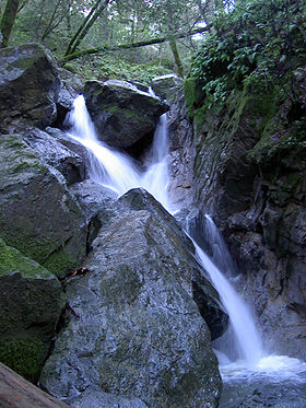
are located in the park, as are the Robert Ferguson Observatory and a 25 feet (8 m) tall seasonal waterfall.
The ridge has two main peaks, the western one being 1939 feet (591 m) above sea level and eastern one being 2265 feet (690.4 m). The East peak contains an extensive microwave antenna. This site was featured in several articles of the Napa Valley Sentinel.
The park's coordinates are 38.44°N 122.5°W, and its official address is 2605 Adobe Canyon Road, Kenwood, CA 95452.