
Sudbury Aqueduct Linear District
Encyclopedia
The Sudbury Aqueduct is an aqueduct
in Massachusetts
. It runs for 16 miles (25.7 km) from Farm Pond at Waverly Street in Framingham
to Chestnut Hill Reservoir
in Boston
. Going east from Framingham, it runs through Sherborn
before entering Natick
. From Natick it runs east through Wellesley
and Needham
to the Charles River
, which it crosses on the Echo Bridge
into Newton
. It ends at the Chestnut Hill Reservoir on the Newton side of the Newton-Boston line. The Massachusetts Water Resources Authority
(MWRA) operates the aqueduct.
to Boston and its surrounding communities. Reservoirs in Framingham and Southborough
were constructed to impound this water at the time of the aqueduct's development, and additional reservoirs in Ashland
and Hopkinton
were constructed in the 1880s in an attempt to meet increased demand. Finally in the 1890s the Sudbury Reservoir
was created in 1898, significantly increasing the amount of water available for distribution.
The aqueduct consists primarily of a horseshoe-shaped brick lining that is 8.5 feet (2.6 m) in diameter and 7.667 feet (2.3 m) high. The bricks are set in concrete atop a foundation of concrete and stone rubble. The aqueduct is covered by an arch built of brick. The aqueduct was designed to carry 80 million gallons of water per day, and is inclined one foot per mile. At a number of places on the aqueduct small buildings were built to house control equipment of various sorts. These include a gate house at Farm Pond (abandoned after a channel was constructed feeding the aqueduct from Framingham Reservoir #1 due to poor water quality at Farm Pond), a metering house in southeastern Framingham, and control houses over weir
s where the aqueduct crosses over other bodies of water. These control points allow water from the aqueduct to be diverted into the watersheds it crosses. There are also control houses on either end of the Rosemary Brook siphon
in Wellesley, where the water is sent through cast iron pipes to traverse an extended low spot on the route. This stretch of the aqueduct illustrates a number of the techniques used in its construction: parts of the aqueduct here are raised on an embankment
, while others are in a cut
, due to significant changes in local topography. Portions of the aqueduct in Natick and Newton were created by tunneling, the longest being a 4635 feet (1,412.7 m) tunnel in Newton. In addition to the Echo Bridge, the aqueduct also passes over the "Waban Arches" bridge. Located in Wellesley near the Elm Bank Reservation, this nine-arch bridge carries the aqueduct across a valley containing Waban Brook near its mouth at the Charles River
. The aqueduct formally ends at a terminal house just above the Chestnut Hill Reservoir in Newton.
. The aqueduct was taken out of regular service in 1974, and now forms part of the MWRA's emergency backup systems.
It was put into emergency use on May 1, 2010 when a 10 feet (3 m) wide supply pipe (only seven years old) broke in Weston
. Clean water was directed through the aqueduct to bypass the break. The aqueduct is still considered a clean way to transfer water, but the Massachusetts Water Resources Authority supplemented the water supply by tapping the Chestnut Hill Reservoir. The Chestnut Hill water was untreated, so about 2 million residents in about 30 communities in the Boston area were under orders for about three days to disinfect tap water by boiling.
On January 18, 1990, the route, buildings and structures associated with the aqueduct were added to the National Register of Historic Places
as the Sudbury Aqueduct Linear District. Much of the aqueduct's route is open to the public as an unimproved walking trail.
Aqueduct
An aqueduct is a water supply or navigable channel constructed to convey water. In modern engineering, the term is used for any system of pipes, ditches, canals, tunnels, and other structures used for this purpose....
in Massachusetts
Massachusetts
The Commonwealth of Massachusetts is a state in the New England region of the northeastern United States of America. It is bordered by Rhode Island and Connecticut to the south, New York to the west, and Vermont and New Hampshire to the north; at its east lies the Atlantic Ocean. As of the 2010...
. It runs for 16 miles (25.7 km) from Farm Pond at Waverly Street in Framingham
Framingham, Massachusetts
Framingham is a New England town in Middlesex County, Massachusetts, United States. The population was 68,318 as of the United States 2010 Census. -History:...
to Chestnut Hill Reservoir
Chestnut Hill Reservoir Historic District
Chestnut Hill Reservoir Historic District is located between Beacon Street and Commonwealth Avenue in Boston, Massachusetts, just east of the Boston College Main Campus Historic District and the Boston-Newton city line...
in Boston
Boston
Boston is the capital of and largest city in Massachusetts, and is one of the oldest cities in the United States. The largest city in New England, Boston is regarded as the unofficial "Capital of New England" for its economic and cultural impact on the entire New England region. The city proper had...
. Going east from Framingham, it runs through Sherborn
Sherborn, Massachusetts
Sherborn is a town in Middlesex County, Massachusetts, United States. It is in area code 508 and has the ZIP code 01770. As of the 2010 U.S. Census, the town population was 4,119. The assessed value of the town for the fiscal year 2005 is $1,008,146,994....
before entering Natick
Natick, Massachusetts
Natick is a town in Middlesex County, Massachusetts, United States. Natick is located near the center of the MetroWest region of Massachusetts, with a population of 33,006 at the 2010 census. Only west from Boston, Natick is considered part of the Greater Boston area...
. From Natick it runs east through Wellesley
Wellesley, Massachusetts
Wellesley is a town in Norfolk County, Massachusetts, United States. It is part of Greater Boston. The population was 27,982 at the time of the 2010 census.It is best known as the home of Wellesley College and Babson College...
and Needham
Needham, Massachusetts
Needham is a town in Norfolk County, Massachusetts, United States. A suburb of Boston, its population was 28,886 at the 2010 census.- History :...
to the Charles River
Charles River
The Charles River is an long river that flows in an overall northeasterly direction in eastern Massachusetts, USA. From its source in Hopkinton, the river travels through 22 cities and towns until reaching the Atlantic Ocean at Boston...
, which it crosses on the Echo Bridge
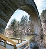
Echo Bridge
Echo Bridge was built to carry the Sudbury Aqueduct over the Charles River from Newton Upper Falls to Needham, Massachusetts. The aqueduct was constructed to carry water from the Sudbury River to Boston. Construction of Echo Bridge began in 1875 and was completed in 1877 by Boston Water Works ,...
into Newton
Newton, Massachusetts
Newton is a city in Middlesex County, Massachusetts, United States bordered to the east by Boston. According to the 2010 U.S. Census, the population of Newton was 85,146, making it the eleventh largest city in the state.-Villages:...
. It ends at the Chestnut Hill Reservoir on the Newton side of the Newton-Boston line. The Massachusetts Water Resources Authority
Massachusetts Water Resources Authority
The Massachusetts Water Resources Authority is a public authority in the Commonwealth of Massachusetts that provides wholesale drinking water and sewage services to certain municipalities and industrial users in the state, primarily in the Boston area.The authority receives water from the Quabbin...
(MWRA) operates the aqueduct.
Construction
The Sudbury Aqueduct was constructed between 1875 and 1878, and was in use for almost 100 years. It was designed to carry water from the watershed of the Sudbury RiverSudbury River
The Sudbury River is a tributary of the Concord River in Middlesex County, Massachusetts, in the United States.Originating in the Cedar Swamp in Westborough, Massachusetts, near the boundary with Hopkinton, it meanders generally northeast to its confluence with the Assabet River at Egg Rock in...
to Boston and its surrounding communities. Reservoirs in Framingham and Southborough
Southborough, Massachusetts
Southborough is an affluent town in Worcester County, Massachusetts, United States. It incorporates the smaller villages of Cordaville, Fayville, and Southville. Its name is often informally shortened to Southboro, a usage seen on many area signs and maps. Its population was 9,767 at the 2010...
were constructed to impound this water at the time of the aqueduct's development, and additional reservoirs in Ashland
Ashland, Massachusetts
Ashland is a town in Middlesex County, Massachusetts, United States. It is part of the MetroWest region. The population was 16,593 at the 2010 census.-History:...
and Hopkinton
Hopkinton, Massachusetts
Hopkinton is a town in Middlesex County, Massachusetts, just under 30 miles west and south of Boston. The town is best known as the starting point of the Boston Marathon, held annually on Patriots' Day in April, and as the home of computer storage firm EMC Corporation.For geographic and demographic...
were constructed in the 1880s in an attempt to meet increased demand. Finally in the 1890s the Sudbury Reservoir
Sudbury Reservoir
The Sudbury Reservoir is a former Boston metropolitan water reservoir located in Framingham, Marlborough, Southborough, and Westborough, Massachusetts, USA...
was created in 1898, significantly increasing the amount of water available for distribution.
The aqueduct consists primarily of a horseshoe-shaped brick lining that is 8.5 feet (2.6 m) in diameter and 7.667 feet (2.3 m) high. The bricks are set in concrete atop a foundation of concrete and stone rubble. The aqueduct is covered by an arch built of brick. The aqueduct was designed to carry 80 million gallons of water per day, and is inclined one foot per mile. At a number of places on the aqueduct small buildings were built to house control equipment of various sorts. These include a gate house at Farm Pond (abandoned after a channel was constructed feeding the aqueduct from Framingham Reservoir #1 due to poor water quality at Farm Pond), a metering house in southeastern Framingham, and control houses over weir
Weir
A weir is a small overflow dam used to alter the flow characteristics of a river or stream. In most cases weirs take the form of a barrier across the river that causes water to pool behind the structure , but allows water to flow over the top...
s where the aqueduct crosses over other bodies of water. These control points allow water from the aqueduct to be diverted into the watersheds it crosses. There are also control houses on either end of the Rosemary Brook siphon
Siphon
The word siphon is sometimes used to refer to a wide variety of devices that involve the flow of liquids through tubes. But in the English language today, the word siphon usually refers to a tube in an inverted U shape which causes a liquid to flow uphill, above the surface of the reservoir,...
in Wellesley, where the water is sent through cast iron pipes to traverse an extended low spot on the route. This stretch of the aqueduct illustrates a number of the techniques used in its construction: parts of the aqueduct here are raised on an embankment
Embankment (transportation)
To keep a road or railway line straight or flat, and where the comparative cost or practicality of alternate solutions is prohibitive, the land over which the road or rail line will travel is built up to form an embankment. An embankment is therefore in some sense the opposite of a cutting, and...
, while others are in a cut
Cut (earthmoving)
In civil engineering, a cut or cutting is where soil or rock material from a hill or mountain is cut out to make way for a canal, road or railway line....
, due to significant changes in local topography. Portions of the aqueduct in Natick and Newton were created by tunneling, the longest being a 4635 feet (1,412.7 m) tunnel in Newton. In addition to the Echo Bridge, the aqueduct also passes over the "Waban Arches" bridge. Located in Wellesley near the Elm Bank Reservation, this nine-arch bridge carries the aqueduct across a valley containing Waban Brook near its mouth at the Charles River
Charles River
The Charles River is an long river that flows in an overall northeasterly direction in eastern Massachusetts, USA. From its source in Hopkinton, the river travels through 22 cities and towns until reaching the Atlantic Ocean at Boston...
. The aqueduct formally ends at a terminal house just above the Chestnut Hill Reservoir in Newton.
Relegation to backup service
In the 20th and 21st centuries the aqueduct's functions were first augmented and then replaced by the Weston Aqueduct, the Hultman Aqueduct, and the MetroWest Water Supply TunnelMetroWest Water Supply Tunnel
The MetroWest Water Supply Tunnel is an advanced underground aqueduct that supplies potable water to residents of much of Greater Boston. It is part of the Massachusetts Water Resources Authority water supply system....
. The aqueduct was taken out of regular service in 1974, and now forms part of the MWRA's emergency backup systems.
It was put into emergency use on May 1, 2010 when a 10 feet (3 m) wide supply pipe (only seven years old) broke in Weston
Weston, Massachusetts
Weston is a suburb of Boston located in Middlesex County, Massachusetts, United States in the Boston metro area. The population of Weston, according to the 2010 U.S. Census, is 11,261....
. Clean water was directed through the aqueduct to bypass the break. The aqueduct is still considered a clean way to transfer water, but the Massachusetts Water Resources Authority supplemented the water supply by tapping the Chestnut Hill Reservoir. The Chestnut Hill water was untreated, so about 2 million residents in about 30 communities in the Boston area were under orders for about three days to disinfect tap water by boiling.
On January 18, 1990, the route, buildings and structures associated with the aqueduct were added to the National Register of Historic Places
National Register of Historic Places
The National Register of Historic Places is the United States government's official list of districts, sites, buildings, structures, and objects deemed worthy of preservation...
as the Sudbury Aqueduct Linear District. Much of the aqueduct's route is open to the public as an unimproved walking trail.