

Subdivisions of Ghana
Encyclopedia
Ghana
Ghana , officially the Republic of Ghana, is a country located in West Africa. It is bordered by Côte d'Ivoire to the west, Burkina Faso to the north, Togo to the east, and the Gulf of Guinea to the south...
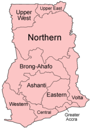
is divided into 10 administrative regions
Regions of Ghana
||Ghana is divided into ten regions :*Ashanti Region *Brong-Ahafo Region *Central Region *Eastern Region *Greater Accra Region *Northern Region *Upper East Region...
, subdivided into a total of 138 districts
Districts of Ghana
||The Districts of Ghana are second-level administrative subdivisions of Ghana, below the level of region.The districts of Ghana were re-organized in 1988/1989 in an attempt to decentralize the government and to combat the rampant corruption amongst officials...
.
Regions
- AshantiAshanti RegionThe Ashanti Region is the third largest of 10 administrative regions in Ghana, occupying a total land surface of 24389 square kilometers or 10.2 per cent of the total land area of Ghana. In terms of population, however, it is the most populated region with a population of 3,612,950 in 2000,...
, capital KumasiKumasiKumasi is a city in southern central Ghana's Ashanti region. It is located near Lake Bosomtwe, in the Rain Forest Region about northwest of Accra. Kumasi is approximately north of the Equator and north of the Gulf of Guinea... - Brong AhafoBrong-Ahafo RegionThe Brong-Ahafo Region is located in mid-western Ghana, between the Ashanti Region and the Northern Region. Its capital is Sunyani.This region was created in 1958. It contains many cultural and wildlife attractions, but it is less known to tourists than the Ashanti, Northern, Central, or Greater...
, capital SunyaniSunyaniSunyani is a city in the West African republic of Ghana, and is the capital of the both the Sunyani District and Brong-Ahafo Region.According to the 2005 population estimates 80,245 people reside in the city of Sunyani, with a growth rate, in the city, of 3.4% per annum.-History of... - Central, capital Cape CoastCape CoastCape Coast, or Cabo Corso, is the capital of the Central Region of Ghana and is also the capital city of the Fante people, or Mfantsefo. It is situated 165 km west of Accra on the Gulf of Guinea. It has a population of 82,291 . From the 16th century the city has changed hands between the...
- Eastern, capital KoforiduaKoforiduaKoforidua, also popularly known as Kof-town, is a city in the West African republic of Ghana, about an hour by road from Accra. It is the capital of the Eastern Region of Ghana and has a population of 87,315 ....
- Greater AccraGreater Accra RegionThe Greater Accra Region is the smallest of Ghana's 10 administrative regions in terms of area, occupying a total land surface of 3,245 square kilometres or 1.4 per cent of the total land area of Ghana...
, capital AccraAccraAccra is the capital and largest city of Ghana, with an urban population of 1,658,937 according to the 2000 census. Accra is also the capital of the Greater Accra Region and of the Accra Metropolitan District, with which it is coterminous... - Northern, capital TamaleTamaleA tamale — or more correctly tamal — is a traditional Latin American dish made of masa , which is steamed or boiled in a leaf wrapper. The wrapping is discarded before eating...
- Upper EastUpper East RegionThe Upper East Region is the smallest of 10 administrative regions in Ghana, occupying a total land surface of 8,842 square kilometers or 2.7 per cent of the total land area of Ghana. In terms of population, it is the ninth most populated region with a population of 920,089 in 2000, accounting for...
, capital BolgatangaBolgatangaBolgatanga, colloquially known as Bolga, is the capital of both the Bolgatanga Municipal District and the Upper East Region of Ghana, and has a population of about 72,000... - Upper WestUpper West RegionThe Upper West Region of Ghana is located in the northwestern corner of the country and is bordered by Burkina Faso to the north. The capital and largest city is Wa. Other towns include Nandom, Daffiema, Jirapa, Kaleo, Nadowli, Lawra and Tumu....
, capital WaWa, GhanaWa is the capital of the Upper West Region of Ghana and is the main city of the Wala people. The majority of the inhabitants are Muslim. It is the seat of the Wa-Na, the Paramount Chief of the Wala traditional area. Features of the town include several mosques, the Wa-Na Palace, a museum and a... - VoltaVolta RegionVolta Region is one of Ghana's ten administrative regions. It is to the east of Lake Volta. Its capital is Ho.-List of districts:The region has 18 districts consisting of 3 municipal and 15 ordinary districts:-Background:...
, capital HoHo, GhanaHo is a town in southeast Ghana and is the capital of the Volta Region. It lies between Mount Adaklu and Mount Galenukui , and is home to a museum, a cathedral and a large prison... - Western, capital Sekondi-TakoradiSekondi-TakoradiSekondi-Takoradi, population 335,000 , comprising the twin cities of Sekondi and Takoradi, is the capital of the Western Region of Ghana. It is Ghana's fourth largest city and an industrial and commercial center. The chief industries are timber, plywood, shipbuilding and railroad repair and...