

Styvechale
Encyclopedia
Coventry
Coventry is a city and metropolitan borough in the county of West Midlands in England. Coventry is the 9th largest city in England and the 11th largest in the United Kingdom. It is also the second largest city in the English Midlands, after Birmingham, with a population of 300,848, although...
. It includes Fenside which forms part of southeast Stivichall. To the north and northwest Stivichall has a shared border with the War Memorial Park
War Memorial Park, Coventry
The War Memorial Park is a large park of about 48.5 hectares situated in southern Coventry. The park was opened in July 1921 as a tribute to the 2,587 Coventrians who died between 1914 and 1918 fighting in the First World War...
, along Coat of Arms Bridge Road. The district of Cheylesmore
Cheylesmore
Cheylesmore is a suburb in the southern half of the city of Coventry, West Midlands, England. It is one of Coventry's largest suburbs, sharing borders with Whitley and Stivichall in the South, extending into Coventry city centre and bordering with Earlsdon in the North. Cheylesmore has two...
is to the northeast with Whitley
Whitley, Coventry
Whitley is a suburb of southern Coventry in the West Midlands of England.-Industry and commerce:Whitley is the home of the Whitley plant, which is the Engineering Centre and Headquarters of Jaguar Cars Limited...
to the east. The southern border of Stivichall is shared with the northern border of the city's Finham
Finham
Finham is a mainly residential part of the city of Coventry, West Midlands, England, and is the city's southernmost suburb, approximately from Coventry city centre. Finham shares its northern boundary along the A45 with the suburb of Styvechale/Stivichall to the north, and part of its southeastern...
and Green Lane
Green Lane, Coventry
Green Lane is a mainly residential district in Coventry, England. The term Green Lane is sometimes also used in a generic sense to refer to road of Green Lane itself and its immediate environs...
districts along the A45
A45 road
The A45 is a major road in England. It runs east from Birmingham past the National Exhibition Centre and the M42, then bypasses Coventry and Rugby, where it briefly merges with the M45 until it continues to Daventry...
dual carriageway.
The western area of Stivichall, known locally as Styvechale Grange, is a large residential district developed during the late-1960s and early-1970s to cater for Coventry's then-rapidly rising population (which peaked at 340,000 inhabitants in 1971).
A rural parish on the outskirts of Coventry, the Styvechale estate had belonged to the Gregory family since the 16th century, but in 1919, the land was purchased by Coventry Corporation and used in part to create the War Memorial Park, with the general development of the area soon following.
The main roads from Coventry to both Leamington Spa
Leamington Spa
Royal Leamington Spa, commonly known as Leamington Spa or Leamington or Leam to locals, is a spa town in central Warwickshire, England. Formerly known as Leamington Priors, its expansion began following the popularisation of the medicinal qualities of its water by Dr Kerr in 1784, and by Dr Lambe...
and Kenilworth
Kenilworth
Kenilworth is a town in central Warwickshire, England. In 2001 the town had a population of 22,582 . It is situated south of Coventry, north of Warwick and northwest of London....
pass through and join within the boundaries of Stivichall, and whilst the estate was still in the Gregory family's ownership, access was denied to the roads unless a toll of 1d per horse and 6d per vehicle was paid to them. The toll house which stood at the junction of the roads was demolished in 1964.
It is thought that the name comes from the Old English 'styfic', meaning 'tree stumps' and 'healh', meaning 'nook' or 'corner'.
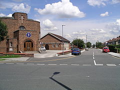
Although the pronunciation of the district is not in doubt, its spelling is a subject of debate. The 'Styvechale' variant is generally deemed more attractive in fitting with the Olde English tradition of the district's name, though since 1945 'Stivichall' has been the official designation for the area, and all direction signage currently reads 'Stivichall'. However, in the early-1990s there was a campaign to reintroduce the 'Styvechale' variant on local signage and within civic circles, with many people finding the Stivichall designation ugly. The local bus operators also historically never display Stivichall or Styvechale on their buses and opt for displaying Fenside instead and when route 2 used to terminate in Exminster Road buses had always displayed Cheylesmore, an alternative to this could have been a destination of 'Howes Farm' in similar fashion to the modern Tanyard Farm and Victoria Farm estates in Coventry.
The site on which Stivichall Primary School
Stivichall Primary School
Stivichall Primary School is situated in the Green Lane area of Coventry, on the city border with Warwickshire. The present Head Teacher is Mr. Chris Rose, having returned to the school after working for the Coventry Local Education Authority ; and the deputy headteacher is Mr. M Baldwin. The...
was built is bounded by Green Lane and Coat of Arms Bridge Road.
Styvechale Manor
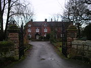
The property, a Grade II listed building, has since been converted into apartments.
Stivichall Hall
Stivichall Hall was built by the Gregory family in the 1750s, on a site south of St James's Church, between the modern Montpellier Close and Ridgeway Avenue. It was a three-storey building with a frontage of five windows on each storey, subsequently extended into a seven-window fronted building. In 1928 it was sold with some of the estate to Coventry corporation, but it became derelict and was demolished after World War II.When Major C. H. Gregory-Hood sold the estate in 1932, he gave an area of fields and woods around Stivichall Croft and Coat of Arms Bridge Road to Coventry Corporation for permanent preservation. An obelisk recording the gift stands on this site.