
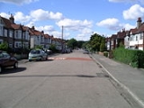
Green Lane, Coventry
Encyclopedia

Coventry
Coventry is a city and metropolitan borough in the county of West Midlands in England. Coventry is the 9th largest city in England and the 11th largest in the United Kingdom. It is also the second largest city in the English Midlands, after Birmingham, with a population of 300,848, although...
, England
England
England is a country that is part of the United Kingdom. It shares land borders with Scotland to the north and Wales to the west; the Irish Sea is to the north west, the Celtic Sea to the south west, with the North Sea to the east and the English Channel to the south separating it from continental...
. The term Green Lane is sometimes also used in a generic sense to refer to road of Green Lane itself and its immediate environs. It is generally considered as one of the more prosperous areas of the city.
The suburb of Finham
Finham
Finham is a mainly residential part of the city of Coventry, West Midlands, England, and is the city's southernmost suburb, approximately from Coventry city centre. Finham shares its northern boundary along the A45 with the suburb of Styvechale/Stivichall to the north, and part of its southeastern...
lies to its south, Styvechale
Styvechale
Stivichall or Styvechale is a mainly residential area of south Coventry. It includes Fenside which forms part of southeast Stivichall. To the north and northwest Stivichall has a shared border with the War Memorial Park, along Coat of Arms Bridge Road. The district of Cheylesmore is to the...
/Stivichall is to the east, the War Memorial Park
War Memorial Park, Coventry
The War Memorial Park is a large park of about 48.5 hectares situated in southern Coventry. The park was opened in July 1921 as a tribute to the 2,587 Coventrians who died between 1914 and 1918 fighting in the First World War...
to its north and the suburbs of Cannon Park
Cannon Park
Cannon Park is a suburb in the southwest of the City of Coventry, West Midlands, England. It can be accessed via the major roads Kenpas Highway or Kenilworth Road. The area has a sizable shopping centre of the same name which features food stores, shops and eateries...
and Canley
Canley
Canley is a suburban neighbourhood located in southwest Coventry, England. Canley became part of Coventry as a result of successive encroachment of the latter's boundaries between 1928 and 1932, having historically been part of the Stoneleigh parish....
to its west. The city centre is approximately 3 km to the north.
The main roads within the Green Lane suburb are Kenpas Highway (west), Green Lane (north), Woodside Avenue, Wainbody Avenue, Moat Avenue, Beanfield Avenue, Grasmere Avenue, Leasowes Avenue, Gretna Road, Gratton Court, Gregory Avenue, Sylvan Drive, Regency Drive, Oak Tree Avenue and Medland Avenue.
The A45 dual-carriageway from Coventry to Birmingham
Birmingham
Birmingham is a city and metropolitan borough in the West Midlands of England. It is the most populous British city outside the capital London, with a population of 1,036,900 , and lies at the heart of the West Midlands conurbation, the second most populous urban area in the United Kingdom with a...
bisects the suburb north-south. A row of shops and a large pub line part of this section of road. Green Lane itself continues south through Finham and onto the B4113 road connecting Coventry with the village of Stoneleigh, Warwickshire
Stoneleigh, Warwickshire
Stoneleigh is a small village in Warwickshire, England on the River Sowe, about 5 miles south of Coventry and 5 miles north of Leamington Spa. The village is situated about northeast of the confluence of the River Sowe and the River Avon.Stoneleigh does not have a public house...
.
History
The Green Lane (the road) is one of the longest in the area, and it is divided into a shorter northern part (in Green Lane) and a longer southern part (in Finham). The two portions of Green Lane (the road) originally formed a crossroads with the A45, but after the A45 was converted into a dual carriageway in the 1950s (approx date) the two parts of Green Lane became discontinuous; however, a subway was built under the A45 for pedestrians in the early-1970s.Green Lane Ex-Services Club
The club was set up over 50 years ago by Ex-Service men after the Second World War. The land was given to the club by Bassett Green, the man who donated the statue of Lady GodivaLady Godiva
Godiva , often referred to as Lady Godiva , was an Anglo-Saxon noblewoman who, according to legend, rode naked through the streets of Coventry in order to gain a remission of the oppressive taxation imposed by her husband on his tenants...
to the City of Coventry.
Inside the walls of the club, under the apex roof, is the original structure consisting of two arch shaped Nissen hut
Nissen hut
A Nissen hut is a prefabricated steel structure made from a half-cylindrical skin of corrugated steel, a variant of which was used extensively during World War II.-Description:...
s. During the war these Nissen Huts stood half a mile away from the current location on the intersection of Kenpas Highway (A45
A45 road
The A45 is a major road in England. It runs east from Birmingham past the National Exhibition Centre and the M42, then bypasses Coventry and Rugby, where it briefly merges with the M45 until it continues to Daventry...
) and Leamington Road (B4113) and was used as a garage for tank repairs. After the war they were bought for £500 and moved to the current location at the bottom of Beanfield Avenue on Leasowes Avenue.
To build the brick exterior wall and existing roof funds were raised by selling some land between the club house and Moat Avenue.
The club has a full trophy cabinet showing the successes at football, snooker, darts and other sporting events over many years.