
Stone, Buckinghamshire
Encyclopedia
Stone is a village in Buckinghamshire
, England. It is located southwest of the town of Aylesbury
, on the A418 road
that links Aylesbury to Thame
. Stone with Bishopstone and Hartwell is a civil parish within Aylesbury Vale
district and also incorporates the nearby settlements of Bishopstone
and Hartwell
.
The architect Clough Williams-Ellis
designed the village hall in 1910.
in origin, and refers literally to boundary stone
or marker stone. In the Domesday Book
of 1086 the village was recorded as Stanes.
The village of Stone adjoins the village of Hartwell
.
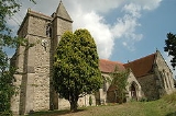
The parish
church is dedicated to St John the Baptist
, and is dated 1273. The graveyard contains the grave of Admiral Smyth
.
described Stone as
and the Royal Astronomical Society
jointly owned the advowson
of the parish. They appointed amateur scientist the Rev. Joseph Bancroft Reade
as vicar
. Reade served as incumbent until 1859, establishing a school and an astronomical observatory, and performing pioneering work in the early development of photography
.
and Hartwell
, and children transfer to the school from Dinton Church of England School, at the age of seven. The school dates from 1871, but most of the present buildings date from 1973 when a major programme of building work provided a hall, new classrooms, a library, changing rooms, offices and an extended playground. The current headteacher is Simon Rose who took over from Ian Stewart in September 2006. The school has been gradually improving in the last few years, since Ofsted
judged it to have "serious weaknesses" in November 2000. In 2006 the school was judged to be "satisfactory" and a 2007 Monitoring Report identified "good progress" in improving the curriculum and teaching. In 2007 the school's Key Stage 2
results matched the England average, although they were slightly below the average for Buckinghamshire.
(later known as St. John's Hospital) was opened in Stone for people with disabilities
or mental illness
es. It was closed in 1991, and the vast expanse of land has since been given over to a new housing estate. Initially it was proposed that the Hospital site be saved and converted but attempts failed because the government insisted it be demolished as it was allegedly more economical. All that remains are the staff houses and the grade-II asylum chapel which is closed and boarded pending conversion to 3 dwellings.
, a Prisoner of War
camp was located in Stone (Camp No. 36 Hartwell Dog Track).
The camp was known to house Italian prisoners from 1942 to 1946 and consisted mostly of tents with one hut. A 1945 aerial view of the camp can be seen on Google Earth
(v.6); this shows camp buildings at Grid reference
SP797120 51.801°N 0.846°W, on what is now the Meadoway housing estate adjacent to Sedrup Lane. Remains of the camp were still evident on the site in the 1950s.
English Heritage
incorrectly shows the camp as being at grid reference SP807121; this is about 1 km to the east, in a field near to Ellen Road on the outskirts of Aylesbury
, and adjacent to where the Walton Court housing estate was later built; the 1945 aerial photos do not support there having been any buildings at that location.
Buckinghamshire
Buckinghamshire is a ceremonial and non-metropolitan home county in South East England. The county town is Aylesbury, the largest town in the ceremonial county is Milton Keynes and largest town in the non-metropolitan county is High Wycombe....
, England. It is located southwest of the town of Aylesbury
Aylesbury
Aylesbury is the county town of Buckinghamshire in South East England. However the town also falls into a geographical region known as the South Midlands an area that ecompasses the north of the South East, and the southern extremities of the East Midlands...
, on the A418 road
A418 road
The A418 road is a main trunk road in Buckinghamshire and Oxfordshire, England. It begins at a roundabout with the A4146 just north of Ascott, near Leighton Buzzard. It then runs south as a single carriageway through Wing to Aylesbury. This stretch is proposed for a dual carriageway bypass. After...
that links Aylesbury to Thame
Thame
Thame is a town and civil parish in Oxfordshire, about southwest of the Buckinghamshire town of Aylesbury. It derives its toponym from the River Thame which flows past the north side of the town....
. Stone with Bishopstone and Hartwell is a civil parish within Aylesbury Vale
Aylesbury Vale
The Aylesbury Vale is a large area of flat land mostly in Buckinghamshire, England. Its boundary is marked by Milton Keynes to the north, Leighton Buzzard and the Chiltern Hills to the east and south, Thame to the south and Bicester and Brackley to the west.The vale is named after Aylesbury, the...
district and also incorporates the nearby settlements of Bishopstone
Bishopstone, Buckinghamshire
Bishopstone is a rural village in the civil parish of Stone with Bishopstone and Hartwell in Aylesbury Vale, Buckinghamshire, England.- History :The village name is a common one in England, and means Bishop's Estate...
and Hartwell
Hartwell
Hartwell is a village in central Buckinghamshire, England. It is to the south of Aylesbury, by the village of Stone.The village name is Anglo Saxon in origin, and means "spring frequented by deer". In the Domesday Book of 1086 it was recorded as Herdeuuelle and Herdewelle.The ruined Hartwell...
.
The architect Clough Williams-Ellis
Clough Williams-Ellis
Sir Bertram Clough Williams-Ellis, CBE, MC was an English-born Welsh architect known chiefly as creator of the Italianate village of Portmeirion in North Wales.-Origins, education and early career:...
designed the village hall in 1910.
Description
The village name is Anglo SaxonOld English language
Old English or Anglo-Saxon is an early form of the English language that was spoken and written by the Anglo-Saxons and their descendants in parts of what are now England and southeastern Scotland between at least the mid-5th century and the mid-12th century...
in origin, and refers literally to boundary stone
Boundary marker
A boundary marker, boundary stone or border stone is a robust physical marker that identifies the start of a land boundary or the change in a boundary, especially a change in a direction of a boundary...
or marker stone. In the Domesday Book
Domesday Book
Domesday Book , now held at The National Archives, Kew, Richmond upon Thames in South West London, is the record of the great survey of much of England and parts of Wales completed in 1086...
of 1086 the village was recorded as Stanes.
The village of Stone adjoins the village of Hartwell
Hartwell
Hartwell is a village in central Buckinghamshire, England. It is to the south of Aylesbury, by the village of Stone.The village name is Anglo Saxon in origin, and means "spring frequented by deer". In the Domesday Book of 1086 it was recorded as Herdeuuelle and Herdewelle.The ruined Hartwell...
.
The parish
Parish
A parish is a territorial unit historically under the pastoral care and clerical jurisdiction of one parish priest, who might be assisted in his pastoral duties by a curate or curates - also priests but not the parish priest - from a more or less central parish church with its associated organization...
church is dedicated to St John the Baptist
John the Baptist
John the Baptist was an itinerant preacher and a major religious figure mentioned in the Canonical gospels. He is described in the Gospel of Luke as a relative of Jesus, who led a movement of baptism at the Jordan River...
, and is dated 1273. The graveyard contains the grave of Admiral Smyth
William Henry Smyth
William Henry Smyth was an English sailor, hydrographer, astronomer and numismatist.-Private Life:...
.
1806 description
In 1806, Magna BritanniaMagna Britannia
Magna Britannia, being a concise topographical account of the several counties of Great Britain was an ambitious topographical and historical survey published by the antiquarians Daniel Lysons and his brother Samuel Lysons in several volumes between 1806 and 1822...
described Stone as
- STONE, in the hundred of Aylesbury and deanery of Wendover, lies nearly three miles west of Aylesbury, on the road to Thame. The manor was anciently in the family of Braci, afterwards in that of Whittingham. It has been since held for many years by the Lees with the adjoining manor of Hartwell, and is now the property of the Rev. Sir George Lee bart.
- The parish church which was consecrated in 1273, retains some vestiges of the architecture of that period. The rectory was given by the Braci family to the priory of Oseney. By the act of parliament which passed for inclosing this parish in 1776, it appears that the Lees were entitled to the great tithes of Southwarp in Stone, and the earl of Chesterfield to those of the remainder of the parish. Allotments of land were then assigned to the impropriators and to the vicar, who was entitled to the tithes of hay. Sir George Lee is patron and incumbent of the vicarage.
Astronomical observatory
In 1839, John LeeJohn Lee (astronomer)
John Lee LL.D , born John Fiott, was an English philanthropist, astronomer, mathematician, antiquarian and barrister.-Family:...
and the Royal Astronomical Society
Royal Astronomical Society
The Royal Astronomical Society is a learned society that began as the Astronomical Society of London in 1820 to support astronomical research . It became the Royal Astronomical Society in 1831 on receiving its Royal Charter from William IV...
jointly owned the advowson
Advowson
Advowson is the right in English law of a patron to present or appoint a nominee to a vacant ecclesiastical benefice or church living, a process known as presentation. In effect this means the right to nominate a person to hold a church office in a parish...
of the parish. They appointed amateur scientist the Rev. Joseph Bancroft Reade
Joseph Bancroft Reade
Rev. Joseph Bancroft Reade FRS was an English clergyman, amateur scientist and pioneer of photography.-Early life:...
as vicar
Vicar
In the broadest sense, a vicar is a representative, deputy or substitute; anyone acting "in the person of" or agent for a superior . In this sense, the title is comparable to lieutenant...
. Reade served as incumbent until 1859, establishing a school and an astronomical observatory, and performing pioneering work in the early development of photography
Photography
Photography is the art, science and practice of creating durable images by recording light or other electromagnetic radiation, either electronically by means of an image sensor or chemically by means of a light-sensitive material such as photographic film...
.
Village school
Stone Church of England Combined School is voluntary controlled, mixed primary school with approximately 180 pupils aged between four and eleven. The school's catchment area includes the nearby villages of BishopstoneBishopstone, Buckinghamshire
Bishopstone is a rural village in the civil parish of Stone with Bishopstone and Hartwell in Aylesbury Vale, Buckinghamshire, England.- History :The village name is a common one in England, and means Bishop's Estate...
and Hartwell
Hartwell
Hartwell is a village in central Buckinghamshire, England. It is to the south of Aylesbury, by the village of Stone.The village name is Anglo Saxon in origin, and means "spring frequented by deer". In the Domesday Book of 1086 it was recorded as Herdeuuelle and Herdewelle.The ruined Hartwell...
, and children transfer to the school from Dinton Church of England School, at the age of seven. The school dates from 1871, but most of the present buildings date from 1973 when a major programme of building work provided a hall, new classrooms, a library, changing rooms, offices and an extended playground. The current headteacher is Simon Rose who took over from Ian Stewart in September 2006. The school has been gradually improving in the last few years, since Ofsted
Ofsted
The Office for Standards in Education, Children's Services and Skills is the non-ministerial government department of Her Majesty's Chief Inspector of Schools In England ....
judged it to have "serious weaknesses" in November 2000. In 2006 the school was judged to be "satisfactory" and a 2007 Monitoring Report identified "good progress" in improving the curriculum and teaching. In 2007 the school's Key Stage 2
Key Stage 2
Key Stage 2 is the legal term for the four years of schooling in maintained schools in England and Wales normally known as Year 3, Year 4, Year 5 and Year 6, when pupils are aged between 7 and 11. The term is applied differently in Northern Ireland where it refers to pupils in Year 5, Year 6 and...
results matched the England average, although they were slightly below the average for Buckinghamshire.
St. John's Hospital
In the early 19th century an asylumPsychiatric hospital
Psychiatric hospitals, also known as mental hospitals, are hospitals specializing in the treatment of serious mental disorders. Psychiatric hospitals vary widely in their size and grading. Some hospitals may specialise only in short-term or outpatient therapy for low-risk patients...
(later known as St. John's Hospital) was opened in Stone for people with disabilities
Disability
A disability may be physical, cognitive, mental, sensory, emotional, developmental or some combination of these.Many people would rather be referred to as a person with a disability instead of handicapped...
or mental illness
Mental illness
A mental disorder or mental illness is a psychological or behavioral pattern generally associated with subjective distress or disability that occurs in an individual, and which is not a part of normal development or culture. Such a disorder may consist of a combination of affective, behavioural,...
es. It was closed in 1991, and the vast expanse of land has since been given over to a new housing estate. Initially it was proposed that the Hospital site be saved and converted but attempts failed because the government insisted it be demolished as it was allegedly more economical. All that remains are the staff houses and the grade-II asylum chapel which is closed and boarded pending conversion to 3 dwellings.
World War II prisoner of war camp
During World War IIWorld War II
World War II, or the Second World War , was a global conflict lasting from 1939 to 1945, involving most of the world's nations—including all of the great powers—eventually forming two opposing military alliances: the Allies and the Axis...
, a Prisoner of War
Prisoner of war
A prisoner of war or enemy prisoner of war is a person, whether civilian or combatant, who is held in custody by an enemy power during or immediately after an armed conflict...
camp was located in Stone (Camp No. 36 Hartwell Dog Track).
The camp was known to house Italian prisoners from 1942 to 1946 and consisted mostly of tents with one hut. A 1945 aerial view of the camp can be seen on Google Earth
Google Earth
Google Earth is a virtual globe, map and geographical information program that was originally called EarthViewer 3D, and was created by Keyhole, Inc, a Central Intelligence Agency funded company acquired by Google in 2004 . It maps the Earth by the superimposition of images obtained from satellite...
(v.6); this shows camp buildings at Grid reference
Grid reference
Grid references define locations on maps using Cartesian coordinates. Grid lines on maps define the coordinate system, and are numbered to provide a unique reference to features....
SP797120 51.801°N 0.846°W, on what is now the Meadoway housing estate adjacent to Sedrup Lane. Remains of the camp were still evident on the site in the 1950s.
English Heritage
English Heritage
English Heritage . is an executive non-departmental public body of the British Government sponsored by the Department for Culture, Media and Sport...
incorrectly shows the camp as being at grid reference SP807121; this is about 1 km to the east, in a field near to Ellen Road on the outskirts of Aylesbury
Aylesbury
Aylesbury is the county town of Buckinghamshire in South East England. However the town also falls into a geographical region known as the South Midlands an area that ecompasses the north of the South East, and the southern extremities of the East Midlands...
, and adjacent to where the Walton Court housing estate was later built; the 1945 aerial photos do not support there having been any buildings at that location.