
Stevens County, Kansas
Encyclopedia
Stevens County is a county
located in the U.S. state
of Kansas
. As of the 2010 census, the county population was 5,724. Its county seat
is Hugoton
. The county is named for the Reconstruction era Pennsylvania
politician Thaddeus Stevens
.
was a violent county seat fight
between groups from Hugoton
and Woodsdale
, where 4 men were murdered.
, county.
 As of the census
of 2000, there were 5,463 people, 1,988 households, and 1,457 families residing in the county. The population density
was 8 people per square mile (3/km²). There were 2,265 housing units at an average density of 3 per square mile (1/km²). The racial makeup of the county was 83.01% White
, 0.93% Black
or African American
, 0.93% Native American
, 0.24% Asian
, 0.02% Pacific Islander
, 13.25% from other races
, and 1.61% from two or more races. 21.73% of the population were Hispanic
or Latino
of any race.
There were 1,988 households out of which 38.80% had children under the age of 18 living with them, 63.10% were married couples
living together, 7.10% had a female householder with no husband present, and 26.70% were non-families. 24.30% of all households were made up of individuals and 12.10% had someone living alone who was 65 years of age or older. The average household size was 2.72 and the average family size was 3.27.
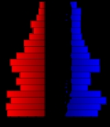
In the county the population was spread out with 31.20% under the age of 18, 8.30% from 18 to 24, 27.80% from 25 to 44, 19.40% from 45 to 64, and 13.30% who were 65 years of age or older. The median age was 34 years. For every 100 females there were 95.30 males. For every 100 females age 18 and over, there were 92.50 males.
The median income for a household in the county was $41,830, and the median income for a family was $49,063. Males had a median income of $36,525 versus $22,803 for females. The per capita income
for the county was $17,814. About 8.30% of families and 10.30% of the population were below the poverty line, including 15.10% of those under age 18 and 4.70% of those age 65 or over.
. None of the cities within the county are considered governmentally independent, and all figures for the townships include those of the cities. In the following table, the population center is the largest city (or cities) included in that township's population total, if it is of a significant size.
General information on Stevens County
Other
Maps
County (United States)
In the United States, a county is a geographic subdivision of a state , usually assigned some governmental authority. The term "county" is used in 48 of the 50 states; Louisiana is divided into parishes and Alaska into boroughs. Parishes and boroughs are called "county-equivalents" by the U.S...
located in the U.S. state
U.S. state
A U.S. state is any one of the 50 federated states of the United States of America that share sovereignty with the federal government. Because of this shared sovereignty, an American is a citizen both of the federal entity and of his or her state of domicile. Four states use the official title of...
of Kansas
Kansas
Kansas is a US state located in the Midwestern United States. It is named after the Kansas River which flows through it, which in turn was named after the Kansa Native American tribe, which inhabited the area. The tribe's name is often said to mean "people of the wind" or "people of the south...
. As of the 2010 census, the county population was 5,724. Its county seat
County seat
A county seat is an administrative center, or seat of government, for a county or civil parish. The term is primarily used in the United States....
is Hugoton
Hugoton, Kansas
Hugoton is a city in and the county seat of Stevens County, Kansas, United States. As of the 2010 census, the city population was 3,904.-History:...
. The county is named for the Reconstruction era Pennsylvania
Pennsylvania
The Commonwealth of Pennsylvania is a U.S. state that is located in the Northeastern and Mid-Atlantic regions of the United States. The state borders Delaware and Maryland to the south, West Virginia to the southwest, Ohio to the west, New York and Ontario, Canada, to the north, and New Jersey to...
politician Thaddeus Stevens
Thaddeus Stevens
Thaddeus Stevens , of Pennsylvania, was a Republican leader and one of the most powerful members of the United States House of Representatives...
.
19th century
On July 25, 1888, the Hay Meadow MassacreHay Meadow Massacre
The Hay Meadow Massacre, July 25, 1888, was the most violent event of the Stevens County, Kansas, county seat fight.In July 1888, Sam Robinson, the marshal of Hugoton and a group of men supporting Hugoton for the county seat planned an outing in No Man's Land just south of the county...
was a violent county seat fight
County seat war
A county seat war is a phenomenon that occurred in the American West as it was being settled, although incidences elsewhere, such as in West Virginia, have been also been recorded. As new towns sprang up and county lines were drawn, there was intense competition for the status and tax benefits...
between groups from Hugoton
Hugoton, Kansas
Hugoton is a city in and the county seat of Stevens County, Kansas, United States. As of the 2010 census, the city population was 3,904.-History:...
and Woodsdale
Woodsdale, Kansas
Woodsdale is a ghost town in Stevens County, Kansas, United States. It was involved in a county seat war with Hugoton.-History:Samuel Newitt Wood and I. C. Price developed the town and it was named for Col. Wood. Its post office was established November 11, 1886, and the town incorporated April...
, where 4 men were murdered.
Law and government
Although the Kansas Constitution was amended in 1986 to allow the sale of alcoholic liquor by the individual drink with the approval of voters, Stevens County has remained a prohibition, or "dry"Dry county
A dry county is a county in the United States whose government forbids the sale of alcoholic beverages. Some prohibit off-premises sale, some prohibit on-premises sale, and some prohibit both. Hundreds of dry counties exist across the United States, almost all of them in the South...
, county.
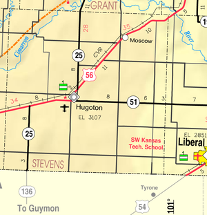
Geography
According to the 2000 census, the county has a total area of 727.71 square miles (1,884.8 km²), of which 727.53 square miles (1,884.3 km²) (or 99.98%) is land and 0.18 square mile (0.4661978598 km²) (or 0.02%) is water.Adjacent counties
- Grant CountyGrant County, KansasGrant County is a county located in southwest Kansas, in the Central United States. As of the 2010 census, the county population was 7,829...
(north) - Haskell CountyHaskell County, KansasHaskell County is a county located in Southwest Kansas, in the Central United States. As of the 2010 census, the county population was 4,256...
(northeast) - Seward CountySeward County, KansasSeward County is a county of the U.S. state of Kansas. As of the 2010 census, the county population was 22,952. The largest city and county seat is Liberal...
(east) - Texas County, OklahomaTexas County, OklahomaTexas County is a county located in the U.S. state of Oklahoma. Texas County was formed at Oklahoma statehood from the central one-third of "Old Beaver County" also known as "No Man's Land"...
(south) - Morton CountyMorton County, KansasMorton County is a county located in the U.S. state of Kansas. As of the 2010 census, the county population was 3,233...
(west) - Stanton CountyStanton County, KansasStanton County is a county located in the U.S. state of Kansas. As of the 2010 census, the county population was 2,235...
(northwest)
Demographics
Census
A census is the procedure of systematically acquiring and recording information about the members of a given population. It is a regularly occurring and official count of a particular population. The term is used mostly in connection with national population and housing censuses; other common...
of 2000, there were 5,463 people, 1,988 households, and 1,457 families residing in the county. The population density
Population density
Population density is a measurement of population per unit area or unit volume. It is frequently applied to living organisms, and particularly to humans...
was 8 people per square mile (3/km²). There were 2,265 housing units at an average density of 3 per square mile (1/km²). The racial makeup of the county was 83.01% White
Race (United States Census)
Race and ethnicity in the United States Census, as defined by the Federal Office of Management and Budget and the United States Census Bureau, are self-identification data items in which residents choose the race or races with which they most closely identify, and indicate whether or not they are...
, 0.93% Black
Race (United States Census)
Race and ethnicity in the United States Census, as defined by the Federal Office of Management and Budget and the United States Census Bureau, are self-identification data items in which residents choose the race or races with which they most closely identify, and indicate whether or not they are...
or African American
Race (United States Census)
Race and ethnicity in the United States Census, as defined by the Federal Office of Management and Budget and the United States Census Bureau, are self-identification data items in which residents choose the race or races with which they most closely identify, and indicate whether or not they are...
, 0.93% Native American
Race (United States Census)
Race and ethnicity in the United States Census, as defined by the Federal Office of Management and Budget and the United States Census Bureau, are self-identification data items in which residents choose the race or races with which they most closely identify, and indicate whether or not they are...
, 0.24% Asian
Race (United States Census)
Race and ethnicity in the United States Census, as defined by the Federal Office of Management and Budget and the United States Census Bureau, are self-identification data items in which residents choose the race or races with which they most closely identify, and indicate whether or not they are...
, 0.02% Pacific Islander
Race (United States Census)
Race and ethnicity in the United States Census, as defined by the Federal Office of Management and Budget and the United States Census Bureau, are self-identification data items in which residents choose the race or races with which they most closely identify, and indicate whether or not they are...
, 13.25% from other races
Race (United States Census)
Race and ethnicity in the United States Census, as defined by the Federal Office of Management and Budget and the United States Census Bureau, are self-identification data items in which residents choose the race or races with which they most closely identify, and indicate whether or not they are...
, and 1.61% from two or more races. 21.73% of the population were Hispanic
Race (United States Census)
Race and ethnicity in the United States Census, as defined by the Federal Office of Management and Budget and the United States Census Bureau, are self-identification data items in which residents choose the race or races with which they most closely identify, and indicate whether or not they are...
or Latino
Race (United States Census)
Race and ethnicity in the United States Census, as defined by the Federal Office of Management and Budget and the United States Census Bureau, are self-identification data items in which residents choose the race or races with which they most closely identify, and indicate whether or not they are...
of any race.
There were 1,988 households out of which 38.80% had children under the age of 18 living with them, 63.10% were married couples
Marriage
Marriage is a social union or legal contract between people that creates kinship. It is an institution in which interpersonal relationships, usually intimate and sexual, are acknowledged in a variety of ways, depending on the culture or subculture in which it is found...
living together, 7.10% had a female householder with no husband present, and 26.70% were non-families. 24.30% of all households were made up of individuals and 12.10% had someone living alone who was 65 years of age or older. The average household size was 2.72 and the average family size was 3.27.
In the county the population was spread out with 31.20% under the age of 18, 8.30% from 18 to 24, 27.80% from 25 to 44, 19.40% from 45 to 64, and 13.30% who were 65 years of age or older. The median age was 34 years. For every 100 females there were 95.30 males. For every 100 females age 18 and over, there were 92.50 males.
The median income for a household in the county was $41,830, and the median income for a family was $49,063. Males had a median income of $36,525 versus $22,803 for females. The per capita income
Per capita income
Per capita income or income per person is a measure of mean income within an economic aggregate, such as a country or city. It is calculated by taking a measure of all sources of income in the aggregate and dividing it by the total population...
for the county was $17,814. About 8.30% of families and 10.30% of the population were below the poverty line, including 15.10% of those under age 18 and 4.70% of those age 65 or over.
Incorporated cities
Name and population (2004 estimate):- HugotonHugoton, KansasHugoton is a city in and the county seat of Stevens County, Kansas, United States. As of the 2010 census, the city population was 3,904.-History:...
, 3,722 (county seat) - MoscowMoscow, KansasMoscow is a city in Stevens County, in southwest Kansas, United States. As of the 2010 census, the city population was 310.-Geography:Moscow is located at , on U.S. Highway 56 in southwest Kansas...
, 255
Townships
Stevens County is divided into six townshipsCivil township
A civil township is a widely used unit of local government in the United States, subordinate to, and geographic divisions of, a county. Specific responsibilities and the degree of autonomy vary based on each state. Civil townships are distinct from survey townships, but in states that have both,...
. None of the cities within the county are considered governmentally independent, and all figures for the townships include those of the cities. In the following table, the population center is the largest city (or cities) included in that township's population total, if it is of a significant size.
| Township | FIPS | Population center |
Population | Population density /km² (/sq mi) |
Land area km² (sq mi) | Water area km² (sq mi) | Water % | Geographic coordinates |
|---|---|---|---|---|---|---|---|---|
| Banner | 04125 | 164 | 1 (2) | 277 (107) | 0 (0) | 0 % | 37°3′41"N 101°11′37"W | |
| Center | 12200 | 4,131 | 15 (38) | 280 (108) | 0 (0) | 0.02% | 37°10′38"N 101°19′7"W | |
| Harmony | 30150 | 143 | 1 (1) | 280 (108) | 0 (0) | 0 % | 37°19′22"N 101°26′55"W | |
| Moscow | 48625 | 711 | 2 (4) | 442 (171) | 0 (0) | 0.09% | 37°18′28"N 101°12′12"W | |
| Voorhees | 74200 | 145 | 0 (1) | 349 (135) | 0 (0) | 0 % | 37°3′26"N 101°23′16"W | |
| West Center | 76800 | 169 | 1 (2) | 257 (99) | 0 (0) | 0 % | 37°11′30"N 101°26′19"W |
Education
Further reading
- History of the State of Kansas; William G. Cutler; A.T. Andreas Publisher; 1883. (Online HTML eBook)
- Kansas : A Cyclopedia of State History, Embracing Events, Institutions, Industries, Counties, Cities, Towns, Prominent Persons, Etc; 3 Volumes; Frank W. Blackmar; Standard Publishing Co; 944 / 955 / 824 pages; 1912. (Volume1 - Download 54MB PDF eBook),(Volume2 - Download 53MB PDF eBook), (Volume3 - Download 33MB PDF eBook)
External links
Official websiteGeneral information on Stevens County
Other
Maps
- Stevens County Map, KDOT
- Kansas Highway Map, KDOT
- Kansas Railroad Map, KDOT
- Kansas School District Boundary Map, KSDE