

Sterling Micropolitan Statistical Area
Encyclopedia
United States Census Bureau
The United States Census Bureau is the government agency that is responsible for the United States Census. It also gathers other national demographic and economic data...
defined Micropolitan Statistical Area
United States micropolitan area
United States Micropolitan Statistical Areas , as defined by the United States Office of Management and Budget, are urban areas in the United States based around a core city or town with a population of 10,000 to 49,999. The micropolitan area designation was created in 2003...
located in the Sterling
Sterling, Colorado
The City of Sterling is a Home Rule Municipality that is the county seat and the most populous city of Logan County, Colorado, United States. The city population was 14,777 at the 2010 census.-Geography:Sterling is located at...
area of the State of Colorado
Colorado
Colorado is a U.S. state that encompasses much of the Rocky Mountains as well as the northeastern portion of the Colorado Plateau and the western edge of the Great Plains...
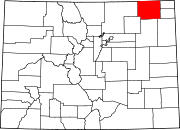
. The Sterling Micropolitan Statistical Area is defined as Logan County, Colorado
Logan County, Colorado
Logan County is the 23rd most extensive of the 64 counties of the State of Colorado of the United States. The county was named for General John A. Logan. The county population was 20,504 at U.S. Census 2000. The county seat is Sterling...
. The Micropolitan Statistical Area had a population of 20,504 at the 2000 Census
United States Census, 2000
The Twenty-second United States Census, known as Census 2000 and conducted by the Census Bureau, determined the resident population of the United States on April 1, 2000, to be 281,421,906, an increase of 13.2% over the 248,709,873 persons enumerated during the 1990 Census...
. A July 1, 2009 U.S. Census Bureau estimate placed the population at 20,772.
The Sterling Micropolitan Statistical Area includes the City of Sterling
Sterling, Colorado
The City of Sterling is a Home Rule Municipality that is the county seat and the most populous city of Logan County, Colorado, United States. The city population was 14,777 at the 2010 census.-Geography:Sterling is located at...
, the Town of Crook
Crook, Colorado
Crook is a Statutory Town in Logan County, Colorado, United States. The population was 128 at the 2000 census.-History:The town was named for General George Crook, officer during the American Civil War and the Indian Wars.-Geography:...
, the Town of Fleming
Fleming, Colorado
Fleming is a Statutory Town in Logan County, Colorado, United States. The population was 426 at the 2000 census.-Geography:Fleming is located at ....
, the Town of Iliff
Iliff, Colorado
The Town of Iliff is a Statutory Town located in Logan County, Colorado, United States. The population was 213 at the 2000 census. The town's name is shared with the 2300 South block in the Denver-Aurora metropolitan area street system; Iliff Avenue is a major traffic artery in Aurora and has an...
, the Town of Merino
Merino, Colorado
Merino is a Statutory Town in Logan County, Colorado, United States. The population was 246 at the 2000 census.-Geography:Merino is located at ....
, the Town of Peetz
Peetz, Colorado
Peetz is a Statutory Town in Logan County, Colorado, United States. The population was 227 at the 2000 census. Peetz is home to the RE-5 School District and...
, and the unincorporated area
Unincorporated area
In law, an unincorporated area is a region of land that is not a part of any municipality.To "incorporate" in this context means to form a municipal corporation, a city, town, or village with its own government. An unincorporated community is usually not subject to or taxed by a municipal government...
s of Logan County
Logan County, Colorado
Logan County is the 23rd most extensive of the 64 counties of the State of Colorado of the United States. The county was named for General John A. Logan. The county population was 20,504 at U.S. Census 2000. The county seat is Sterling...
.
See also
- Summit County, ColoradoSummit County, ColoradoSummit County is the 19th most populous of the 64 counties of the state of Colorado of the United States. The county population was 23,538 at U.S. Census 2000. The county seat is Breckenridge...
- Colorado census statistical areas
- Colorado metropolitan areasColorado metropolitan areasThe metropolitan areas of the State of Colorado include the urban statistical areas defined by the United States Office of Management and Budget and regions of urban population defined by other organizations.-Census statistical areas:...
- Combined Statistical AreaCombined Statistical AreaThe United States Office of Management and Budget defines micropolitan and metropolitan statistical areas. Metropolitan and micropolitan statistical areas consist of one or more counties...
- Core Based Statistical AreaCore based statistical areaA Core Based Statistical Area is a U.S. geographic area defined by the Office of Management and Budget based around an urban center of at least 10,000 people and adjacent areas that are socioeconomically tied to the urban center by commuting. Areas defined on the basis of these standards applied...
- Metropolitan Statistical Area
- Micropolitan Statistical Area
- Table of United States Combined Statistical AreasTable of United States Combined Statistical Areasthumb|An enlargeable map of the 125 [[Combined Statistical Area]]s of the [[United States]]The United States Office of Management and Budget has defined 125 Combined Statistical Areas for the United States of America...
- Table of United States Metropolitan Statistical AreasTable of United States Metropolitan Statistical Areasthumb|An enlargeable map of the 942 [[Core Based Statistical Area]]s of the [[United States]]. The 367 [[Metropolitan Statistical Area]]s are shown in red....
- Table of United States Micropolitan Statistical AreasTable of United States Micropolitan Statistical Areasthumb|An enlargeable map of the 942 [[Core Based Statistical Area]]s of the [[United States]]. The 576 [[Micropolitan Statistical Area]]s are shown in blue....
- Table of United States primary census statistical areas
- Census statistical areas adjacent to the Sterling Micropolitan Statistical Area:
- Denver-Aurora-Boulder Combined Statistical AreaDenver-Aurora-Boulder Combined Statistical Areathumb|300px|Map of the 12-county Denver-Aurora-Boulder Combined Statistical AreaThe Denver-Aurora-Boulder, CO Combined Statistical Area is a United States Census Bureau defined Combined Statistical Area located in the Denver region of the state of Colorado...
- Fort Morgan Micropolitan Statistical AreaFort Morgan Micropolitan Statistical AreaThe Fort Morgan Micropolitan Statistical Area is a United States Census Bureau defined Micropolitan Statistical Area located in the Fort Morgan area of the State of Colorado. The Fort Morgan Micropolitan Statistical Area is defined as Morgan County, Colorado. The Micropolitan Statistical Area had...
- Greeley Metropolitan Statistical Area
- Denver-Aurora-Boulder Combined Statistical Area