

Steinhatchee River
Encyclopedia
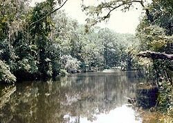
The Steinhatchee River is a short river in the Big Bend
region of Florida
in the U.S.A.
. The river rises in the Mallory Swamp just south of Mayo
in Lafayette County
and flows for 34.5 miles (55.5 km) out of Lafayette County, forming the boundary between Dixie County
and Taylor County
to the Gulf of Mexico
. It has a drainage basin
of 586 square miles (1,517.7 km²). The river has also been known as the Hittenhatchee, Esteenhatchee and Isteenhatchee.
 The only community along the river is Steinhatchee
near its mouth. The river is not developed, being used solely for recreation. About 1 miles (1.6 km) of the river goes underground as a subterranean river
near where U.S. Route 19
crosses the river. 8 miles (12.9 km) from the river's mouth is Steinhatchee Falls, where the river drops several feet.
Big Bend (Florida)
The Big Bend of Florida, U.S.A., is an informal region of the state with no official surveyed boundary. It includes part of the counties of the Florida Panhandle. Geologists prefer to characterize Florida’s Big Bend as the drowned karst section of the coast that occurs between the mouth of the...
region of Florida
Florida
Florida is a state in the southeastern United States, located on the nation's Atlantic and Gulf coasts. It is bordered to the west by the Gulf of Mexico, to the north by Alabama and Georgia and to the east by the Atlantic Ocean. With a population of 18,801,310 as measured by the 2010 census, it...
in the U.S.A.
United States
The United States of America is a federal constitutional republic comprising fifty states and a federal district...
. The river rises in the Mallory Swamp just south of Mayo
Mayo, Florida
Mayo is a town and the only municipality in Lafayette County, Florida, United States. The population was 988 at the 2000 census. As of 2004, the population recorded by the U.S. Census Bureau is 1,009...
in Lafayette County
Lafayette County, Florida
Lafayette County is a county located in the state of Florida. As of 2000, the population was 7,022. It is the second least populated county in the state, having one more resident, according to the 2000 census, than Liberty County, Florida. The U.S. Census Bureau 2005 estimate for the county is...
and flows for 34.5 miles (55.5 km) out of Lafayette County, forming the boundary between Dixie County
Dixie County, Florida
Dixie County is a county located in the U.S. state of Florida. As of 2000, the population was 13,827. The U.S. Census Bureau 2005 estimate for the county is 14,647 . Its county seat is Cross City, Florida.- History :...
and Taylor County
Taylor County, Florida
Taylor County is a county located in the state of Florida. As of 2000, the population was 19,256. The U.S. Census Bureau 2005 estimate for the county was 19,622 . Its county seat is Perry, Florida.- History :Taylor County was created in 1856...
to the Gulf of Mexico
Gulf of Mexico
The Gulf of Mexico is a partially landlocked ocean basin largely surrounded by the North American continent and the island of Cuba. It is bounded on the northeast, north and northwest by the Gulf Coast of the United States, on the southwest and south by Mexico, and on the southeast by Cuba. In...
. It has a drainage basin
Drainage basin
A drainage basin is an extent or an area of land where surface water from rain and melting snow or ice converges to a single point, usually the exit of the basin, where the waters join another waterbody, such as a river, lake, reservoir, estuary, wetland, sea, or ocean...
of 586 square miles (1,517.7 km²). The river has also been known as the Hittenhatchee, Esteenhatchee and Isteenhatchee.
Steinhatchee, Florida
Steinhatchee is a Gulf coastal community in the southern part of Taylor County, Florida. Steinhatchee is located at , 33 miles By Hwy 38.09 miles south of the county seat of Perry. Just aross the Steinhatchee River is Jena, which is in Dixie County. Steinhatchee is 19.27 Hwy miles North of The...
near its mouth. The river is not developed, being used solely for recreation. About 1 miles (1.6 km) of the river goes underground as a subterranean river
Subterranean river
A subterranean river is a river that runs wholly or partly beneath the ground surface – one where the riverbed does not represent the surface of the Earth ....
near where U.S. Route 19
U.S. Route 19
U.S. Route 19 is a north–south U.S. Highway. Despite encroaching Interstate Highways, the route has remained a long-haul route, connecting the Gulf of Mexico with Lake Erie....
crosses the river. 8 miles (12.9 km) from the river's mouth is Steinhatchee Falls, where the river drops several feet.