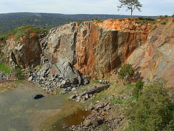
Statham's Quarry
Encyclopedia

Quarry
A quarry is a type of open-pit mine from which rock or minerals are extracted. Quarries are generally used for extracting building materials, such as dimension stone, construction aggregate, riprap, sand, and gravel. They are often collocated with concrete and asphalt plants due to the requirement...
on the Darling Scarp
Darling Scarp
The Darling Scarp, also referred to as the Darling Range or Darling Ranges, is a low escarpment running north-south to the east of the Swan Coastal Plain and Perth, Western Australia...
on the southern side of the entrance of the Helena River
Helena River
The Helena River is a tributary of the Swan River in Western Australia. The river rises in country east of Mount Dale and moves to the north west to Mundaring Weir, where it is dammed...
valley on to the Swan Coastal Plain
Swan Coastal Plain
The Swan Coastal Plain in Western Australia is the geographic feature which contains the Swan River as it travels west to the Indian Ocean. The coastal plain continues well beyond the boundaries of the Swan River and its tributaries, as a geological and biological zone, one of Western Australia's...
in Perth, Western Australia
Perth, Western Australia
Perth is the capital and largest city of the Australian state of Western Australia and the fourth most populous city in Australia. The Perth metropolitan area has an estimated population of almost 1,700,000....
. It is located in Gooseberry Hill
Gooseberry Hill, Western Australia
Gooseberry Hill is a suburb of Perth, Western Australia, located within the Shire of Kalamunda. It is the site of Gooseberry Hill National Park....
and is within the bounds of the Gooseberry Hill National Park
Gooseberry Hill National Park
Gooseberry Hill National Park is a national park in Western Australia , in the locality of Gooseberry Hill, Western Australia 21 km east of Perth. It is at the southern side of the mouth of the Helena Valley on the Darling Scarp. Statham's Quarry is located within the park boundary.The park...
History
Statham's Quarry is considered a rare example of a stone quarry which has retained physical evidence of its operations and is associated with the development of the quarry industry in Western AustraliaWestern Australia
Western Australia is a state of Australia, occupying the entire western third of the Australian continent. It is bounded by the Indian Ocean to the north and west, the Great Australian Bight and Indian Ocean to the south, the Northern Territory to the north-east and South Australia to the south-east...
.
The quarry was established by Thomas Statham and William Burton in 1894 until Statham's death in 1920. The Perth City Council operated the quarry following Statham's death and material from the quarry was used to as street paving in Perth during the early 1900's. The rocks for the groyne at City Beach
City Beach, Western Australia
City Beach is a beachside suburb of Perth, Western Australia, located within the Town of Cambridge. Its postcode is 6015. The term "City Beach" is also used to describe a specific beach located within the suburb of the same name....
also came from the quarry
There was also a clay quarry operation known as Statham's in Glen Forrest which was a brickworks.
The quarry is the claimed location of one of the most extensive dolerite dykes on the Darling Scarp.
The quarry was serviced by the Kalamunda Zig Zag
Kalamunda Zig Zag
The Kalamunda Zig Zag was completed in 1891, as part of the Upper Darling Range Railway line in Western Australia which was built by the Canning Jarrah Timber Company to supply railway sleepers to Perth's growing railway system....
section of the Upper Darling Range Railway during the time of its operation (which closed in 1949), and was finally put out of operation by a bushfire in 1957. The location has been susceptible to bushfires, the most recent being in the early 2000's which was severe and very hot, reducing the ground cover around the quarry and adjacent country severely.
Current usage
The main current usage of the quarry is rock climbingRock climbing
Rock climbing also lightly called 'The Gravity Game', is a sport in which participants climb up, down or across natural rock formations or artificial rock walls. The goal is to reach the summit of a formation or the endpoint of a pre-defined route without falling...
and abseiling
Abseiling
Abseiling , rappelling in American English, is the controlled descent down a rock face using a rope; climbers use this technique when a cliff or slope is too steep and/or dangerous to descend without protection.- Slang terms :...
, with the Department of Environment and Conservation providing facilities and maintaining the site. Dangerous areas are signed and fenced off.
The quarry's importance as a safe easily accessible and well maintained climbing and abseiling location close to the metropolitan area of Perth can be found in the climbing records.
Map
- Allen, M. W.(1928) Darling Range Quarry [cartographic material] : City of Perth. Perth, W.A. Scale 1:792 [1 in. = 1 chain] (Battye Library catalogue description: Map of Perth City Council's Darling Range Quarry (Statham's Quarry) showing the quarry face with contours, railway and sidings, buildings, fences, telephone lines, pipes, formation of Canning Jarrah Timber Company's old line, Ridge Hill and Stathams (old) sidings, watercourses, heights above sea level, boundary of Perth City Council reserve. Battye accession number 009255.
Further reading
- Mansfield, Frank.(2004) Statham's Quarry Gooseberry Hill, W.A. : F. Mansfield (typescript at Battye Library)

