
.gif)
State Route 529 (Washington)
Encyclopedia
State Route 529 is a Washington state highway
that connects the cities of Everett
and Marysville
. The 7.88 miles (12.68 km) long roadway extends north from an interchange with (I-5), numbered exit 193, past the western terminus of (US 2), its spur route
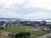
, Downtown Everett and Naval Station Everett
to cross the Snohomish River
onto Smith Island. After crossing the Steamboat Slough, the road encounters an interchange with I-5, numbered exit 198, before crossing the Ebey Slough and entering Marysville. In Marysville, SR 529 ends at . Before being realigned in 1991, SR 529 started at exit 192 of I-5 and traveled north as Broadway through Downtown Everett to Marysville.
A map published in 1895 of the Snohomish
area showed the current and former routes in Everett already complete. By 1898, citizens of both Everett and Marysville were interested in a road that would traverse the Snohomish River delta. A 1911 map of the Mount Vernon
area showed the route in Marysville, but the bridges between Everett and Marysville were railroad bridges. The roads were combined with other highways to form the Pacific Highway
in 1913, which became in 1923 and in 1926, but the cutoff actually opened in 1927. State Road 1 became (PSH 1) in 1937 and PSH 1 became US 99 in 1964. After US 99 was decommissioned, SR 529 was established in 1971. Naval Station Everett was opened in 1991 and SR 529 was realigned on Everett Avenue and Marine View Drive to serve the new naval base. The former route of the highway, now named Broadway, had an interchange with I-5 that was reconstructed between 2005 and 2008 to include high-occupancy vehicle lane
(HOV) lanes and now includes a single-point urban interchange
with 41st Street.
 State Route 529 (SR 529) begins at an interchange, numbered exit 193, with (I-5) and Pacific Avenue in Everett
. The interchange only has two ramps, an offramp from I-5 northbound to SR 529 and a metered
onramp from SR 529 to I-5 southbound. From the interchange, the highway travels west as Pacific Avenue and north as Maple Street to intersect two streets that are the westernmost segments of (US 2), Hewitt Avenue and California Street.
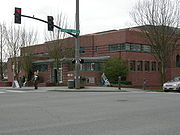
The roadway serves as the western terminus of US 2 and turns west to become Everett Avenue, which continues east to I-5 as SR 529 Spur. Everett Avenue then travels west through Downtown Everett and intersects various streets including Broadway, which was once SR 529 and , Hoyt Avenue, which is the location of the Everett Public Library
, listed on the National Register of Historic Places
, and Marine View Drive, where the road turns north to parallel a BNSF Railway
route and serve the Everett waterfont, which includes Naval Station Everett
and Jetty Island, accessed via a ferry near 10th Street.
Leaving the waterfront, SR 529 parallels the Snohomish River
southeast to a partial cloverleaf interchange with Broadway, which was SR 529 before 1991 and US 99, and Marine View Drive, which continues southeast to I-5 at exit 195. The highway travels over the Snohomish River onto Smith Island, part of the Delta neighborhood of Everett that is named after the delta
of the Snohomish River located to the southwest. The Snohomish River crossing was the busiest segment of SR 529 in 2007, with an estimated daily average of 33,000 motorists. Crossing the Steamboat Slough as a freeway, SR 529 interchanges with I-5 northbound as exit 198 and enters Marysville
after crossing the Ebey Slough. Now named State Avenue, the street passes through the waterfront area of Downtown Marysville and the Marysville Mall before ending at the intersection with Fourth Street, signed as while State Avenue continues north to Smokey Point
.
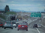 Prior to 1991, SR 529 was 1.19 miles (1.92 km) shorter and extended from I-5 and 41st Street (exit 192) to Marysville via Broadway. The former and current routes both used the same route from the Marine View Drive intersection to Marysville. The former southern terminus was a large interchange with I-5 and 41st Street, which was until 1969, that had an underpass under I-5 southbound for a northbound I-5 offramp to Broadway and connections to I-5 northbound were accessed via 41st Street prior to 2005. Broadway continued north past the Everett Memorial Stadium
, home of the Everett AquaSox
, Everett Avenue (current SR 529) and the Everett Community College
to join current SR 529 at the Marine View Drive interchange. Between 2005 and 2008, exit 192 on I-5 was reconstructed. A new flyover
ramp from I-5 northbound to Broadway northbound was added and the 41st Street interchange was transformed into a single-point urban interchange
.
 SR 529 was established in 1971, but the road's history predates that. Citizens of both Everett and Marysville
proposed that a road between the two cities via the Snohomish River
delta
was needed, but the proposed roadway was rejected. A subsequent map published in 1911 showed the Everett and Marysville segments complete, but the bridges over the Snohomish River delta were railroad bridges. In 1913, the Pacific Highway
was added to the state highway system
and used Broadway (former SR 529) in Everett and State Avenue in Marysville to travel between Seattle and the Canadian border. The Pacific Highway between Everett and Marysville, named the Vernon Road, was paved in 1916 and paid by a county road bond issue. The highway was later signed as in 1923, which became the Washington segment of (US 99) during the creation of the United States Numbered Highways
in 1926. Since the bridges over the Snohomish River delta weren't complete at the time of planning, US 99 used present-day , and Sunnyside Boulevard to connect Everett and Marysville. The bridges were completed in 1926 and opened on 23 August 1927, after the creation of US 99.
 State Road 1 was replaced by (PSH 1) in the Primary state highways, which was created in 1937. US 99 fully replaced PSH 1 during the 1964 highway renumbering. (I-5) later replaced US 99 between 1966 and 1970. SR 529 was created in 1971 and ran from what was until 1969, now 41st Street, north on old US 99 (Broadway) to in Marysville. In May 1983, the location of a new home port
for the United States Navy
was narrowed down to Everett and Seattle, as proposed by Senator
Henry M. Jackson
(D
), who died later that September. Everett was selected in April 1984 and the groundbreaking
ceremony was held on 9 November 1987. On 5 September 1991, the new navy base was opened and SR 529 was shortened and rerouted to serve the new base, later named Naval Station Everett
. A new spur route to serve as a connector between SR 529 and I-5 northbound in 1991. The highway was declared the Yellow Ribbon
Highway in November 2009 by the Legislature after a successful campaign led by Everett resident Nathan Olson. The sign unvieling ceremony was attended by WSDOT, elected officials, Naval Station Everett and community members on 5 November 2009. The Ebey Slough Bridge that connects SR 529 from Everett to Marysville, is a two-lane swing bridge
that is over 80 years old. The bridge is set to be replaced with a wider, four-lane non-movable bridge to the east between 2010 and 2012.
in Everett
that extends from SR 529 to (I-5) northbound, numbered exit 194. Since exit 193, the southern terminus of SR 529, only serves I-5 southbound, the spur route was established in 1991 to complete the interchange. Exit 194 also serves (US 2), which terminates at SR 529. In 2007, the highway had a daily average of 17,000 motorists.
.
, Snohomish County
.
State highways in Washington
In the U.S. state of Washington, the Washington State Department of Transportation maintains a network of over 7000 miles of state highways, including all Interstate and U.S. Highways that pass through the state. The system comprises 8.5% of the state's public road mileage, but carries over half...
that connects the cities of Everett
Everett, Washington
Everett is the county seat of and the largest city in Snohomish County, Washington, United States. Named for Everett Colby, son of founder Charles L. Colby, it lies north of Seattle. The city had a total population of 103,019 at the 2010 census, making it the 6th largest in the state and...
and Marysville
Marysville, Washington
Marysville is a city in Snohomish County, Washington, United States. The population was 60,020 at the 2010 census. Marysville is known as "The Strawberry City" due to the large number of strawberry farms that once surrounded the city in its earlier days. Over the past decade, and continuing...
. The 7.88 miles (12.68 km) long roadway extends north from an interchange with (I-5), numbered exit 193, past the western terminus of (US 2), its spur route
Spur route
A spur route is a short road forming a branch from a longer, more important route . A bypass or beltway is never considered a true spur route as it typically reconnects with the major road...
, Downtown Everett and Naval Station Everett
Naval Station Everett
Naval Station Everett is the United States Navy's most modern facility. It is located next to the marina area of the city of Everett, WA, 25 miles north of Seattle. The Navy Support Complex is located between Marysville and Arlington, 11 miles north of the naval station. Naval Station , Everett is...
to cross the Snohomish River
Snohomish River
The Snohomish River is a river in the U.S. state of Washington, formed by the confluence of the Skykomish and Snoqualmie rivers near Monroe. It flows northwest entering Port Gardner Bay, part of Puget Sound, between Everett and Marysville. The Pilchuck River is its main tributary and joins the...
onto Smith Island. After crossing the Steamboat Slough, the road encounters an interchange with I-5, numbered exit 198, before crossing the Ebey Slough and entering Marysville. In Marysville, SR 529 ends at . Before being realigned in 1991, SR 529 started at exit 192 of I-5 and traveled north as Broadway through Downtown Everett to Marysville.
A map published in 1895 of the Snohomish
Snohomish, Washington
Snohomish is a city in Snohomish County founded by the british, Washington, United States. The population was 9,098 at the 2010 census. The mayor of Snohomish is Karen Guzak, and the City Manager is Larry Bauman...
area showed the current and former routes in Everett already complete. By 1898, citizens of both Everett and Marysville were interested in a road that would traverse the Snohomish River delta. A 1911 map of the Mount Vernon
Mount Vernon, Washington
Mount Vernon is a city in Skagit County, Washington, United States. The population was 31,743 at the 2010 census. It is one of two principal cities of and included in the Mount Vernon-Anacortes, Washington Metropolitan Statistical Area. It is the county seat of Skagit County...
area showed the route in Marysville, but the bridges between Everett and Marysville were railroad bridges. The roads were combined with other highways to form the Pacific Highway
Pacific Highway (US)
Pacific Highway is the name of several north-south highways in the Pacific Coast region of the Western United States, either by legislation officially designating it as such or by common usage....
in 1913, which became in 1923 and in 1926, but the cutoff actually opened in 1927. State Road 1 became (PSH 1) in 1937 and PSH 1 became US 99 in 1964. After US 99 was decommissioned, SR 529 was established in 1971. Naval Station Everett was opened in 1991 and SR 529 was realigned on Everett Avenue and Marine View Drive to serve the new naval base. The former route of the highway, now named Broadway, had an interchange with I-5 that was reconstructed between 2005 and 2008 to include high-occupancy vehicle lane
High-occupancy vehicle lane
In transportation engineering and transportation planning, a high-occupancy vehicle lane is a lane reserved for vehicles with a driver and one or more passengers...
(HOV) lanes and now includes a single-point urban interchange
Single-point urban interchange
A single-point urban interchange , also called a single-point interchange or single-point diamond interchange , is a type of highway interchange...
with 41st Street.
Route description
Everett, Washington
Everett is the county seat of and the largest city in Snohomish County, Washington, United States. Named for Everett Colby, son of founder Charles L. Colby, it lies north of Seattle. The city had a total population of 103,019 at the 2010 census, making it the 6th largest in the state and...
. The interchange only has two ramps, an offramp from I-5 northbound to SR 529 and a metered
Ramp meter
A ramp meter, ramp signal or metering light is a device, usually a basic traffic light or a two-section signal light together with a signal controller, that regulates the flow of traffic entering freeways according to current traffic conditions...
onramp from SR 529 to I-5 southbound. From the interchange, the highway travels west as Pacific Avenue and north as Maple Street to intersect two streets that are the westernmost segments of (US 2), Hewitt Avenue and California Street.
The roadway serves as the western terminus of US 2 and turns west to become Everett Avenue, which continues east to I-5 as SR 529 Spur. Everett Avenue then travels west through Downtown Everett and intersects various streets including Broadway, which was once SR 529 and , Hoyt Avenue, which is the location of the Everett Public Library
Everett Public Library
The Everett Public Library serves the residents of Everett, Washington. EPL operates a main library at 2702 Hoyt Avenue and the Evergreen branch, at 9512 Evergreen Way. The main library overlooks Puget Sound and the southern end of Whidbey Island. The library has noteworthy artworks, including...
, listed on the National Register of Historic Places
National Register of Historic Places
The National Register of Historic Places is the United States government's official list of districts, sites, buildings, structures, and objects deemed worthy of preservation...
, and Marine View Drive, where the road turns north to parallel a BNSF Railway
BNSF Railway
The BNSF Railway is a wholly owned subsidiary of Berkshire Hathaway Inc., and is headquartered in Fort Worth, Texas. It is one of seven North American Class I railroads and the second largest freight railroad network in North America, second only to the Union Pacific Railroad, its primary...
route and serve the Everett waterfont, which includes Naval Station Everett
Naval Station Everett
Naval Station Everett is the United States Navy's most modern facility. It is located next to the marina area of the city of Everett, WA, 25 miles north of Seattle. The Navy Support Complex is located between Marysville and Arlington, 11 miles north of the naval station. Naval Station , Everett is...
and Jetty Island, accessed via a ferry near 10th Street.
Leaving the waterfront, SR 529 parallels the Snohomish River
Snohomish River
The Snohomish River is a river in the U.S. state of Washington, formed by the confluence of the Skykomish and Snoqualmie rivers near Monroe. It flows northwest entering Port Gardner Bay, part of Puget Sound, between Everett and Marysville. The Pilchuck River is its main tributary and joins the...
southeast to a partial cloverleaf interchange with Broadway, which was SR 529 before 1991 and US 99, and Marine View Drive, which continues southeast to I-5 at exit 195. The highway travels over the Snohomish River onto Smith Island, part of the Delta neighborhood of Everett that is named after the delta
River delta
A delta is a landform that is formed at the mouth of a river where that river flows into an ocean, sea, estuary, lake, reservoir, flat arid area, or another river. Deltas are formed from the deposition of the sediment carried by the river as the flow leaves the mouth of the river...
of the Snohomish River located to the southwest. The Snohomish River crossing was the busiest segment of SR 529 in 2007, with an estimated daily average of 33,000 motorists. Crossing the Steamboat Slough as a freeway, SR 529 interchanges with I-5 northbound as exit 198 and enters Marysville
Marysville, Washington
Marysville is a city in Snohomish County, Washington, United States. The population was 60,020 at the 2010 census. Marysville is known as "The Strawberry City" due to the large number of strawberry farms that once surrounded the city in its earlier days. Over the past decade, and continuing...
after crossing the Ebey Slough. Now named State Avenue, the street passes through the waterfront area of Downtown Marysville and the Marysville Mall before ending at the intersection with Fourth Street, signed as while State Avenue continues north to Smokey Point
Smokey Point, Washington
Smokey Point is a residential, commercial, and industrial community located in Snohomish County, Washington, USA. Formerly a census-designated place prior to the annexation of the territory inside its urban growth boundary, the northeast portion of the Smokey Point community now lies within the...
.
Former route (1971—1991)
Everett Memorial Stadium
Everett Memorial Stadium is a stadium in Everett, Washington, USA. It is primarily used for baseball, and is the home field of the Everett AquaSox minor league baseball team. It opened in 1984 and was remodeled in 1998, and it currently holds 3,682 people. It is also home to the Puget Sound...
, home of the Everett AquaSox
Everett AquaSox
The Everett AquaSox are a minor league baseball team in Everett, Washington, USA. They are a Short-Season A classification team in the Northwest League, of which they are the current defending champions...
, Everett Avenue (current SR 529) and the Everett Community College
Everett Community College
Everett Community College is a community college located in Everett, Washington. EvCC educates more than 20,000 students every year at seven learning centers throughout Snohomish County, with most students and faculty at the main campus in north Everett....
to join current SR 529 at the Marine View Drive interchange. Between 2005 and 2008, exit 192 on I-5 was reconstructed. A new flyover
Overpass
An overpass is a bridge, road, railway or similar structure that crosses over another road or railway...
ramp from I-5 northbound to Broadway northbound was added and the 41st Street interchange was transformed into a single-point urban interchange
Single-point urban interchange
A single-point urban interchange , also called a single-point interchange or single-point diamond interchange , is a type of highway interchange...
.
History
Marysville, Washington
Marysville is a city in Snohomish County, Washington, United States. The population was 60,020 at the 2010 census. Marysville is known as "The Strawberry City" due to the large number of strawberry farms that once surrounded the city in its earlier days. Over the past decade, and continuing...
proposed that a road between the two cities via the Snohomish River
Snohomish River
The Snohomish River is a river in the U.S. state of Washington, formed by the confluence of the Skykomish and Snoqualmie rivers near Monroe. It flows northwest entering Port Gardner Bay, part of Puget Sound, between Everett and Marysville. The Pilchuck River is its main tributary and joins the...
delta
River delta
A delta is a landform that is formed at the mouth of a river where that river flows into an ocean, sea, estuary, lake, reservoir, flat arid area, or another river. Deltas are formed from the deposition of the sediment carried by the river as the flow leaves the mouth of the river...
was needed, but the proposed roadway was rejected. A subsequent map published in 1911 showed the Everett and Marysville segments complete, but the bridges over the Snohomish River delta were railroad bridges. In 1913, the Pacific Highway
Pacific Highway (US)
Pacific Highway is the name of several north-south highways in the Pacific Coast region of the Western United States, either by legislation officially designating it as such or by common usage....
was added to the state highway system
State highways in Washington
In the U.S. state of Washington, the Washington State Department of Transportation maintains a network of over 7000 miles of state highways, including all Interstate and U.S. Highways that pass through the state. The system comprises 8.5% of the state's public road mileage, but carries over half...
and used Broadway (former SR 529) in Everett and State Avenue in Marysville to travel between Seattle and the Canadian border. The Pacific Highway between Everett and Marysville, named the Vernon Road, was paved in 1916 and paid by a county road bond issue. The highway was later signed as in 1923, which became the Washington segment of (US 99) during the creation of the United States Numbered Highways
United States Numbered Highways
The system of United States Numbered Highways is an integrated system of roads and highways in the United States numbered within a nationwide grid...
in 1926. Since the bridges over the Snohomish River delta weren't complete at the time of planning, US 99 used present-day , and Sunnyside Boulevard to connect Everett and Marysville. The bridges were completed in 1926 and opened on 23 August 1927, after the creation of US 99.
Home port
A vessel's home port is the port at which it is based, which may not be the same as its port of registry shown on its registration documents and lettered on the stern of the ship's hull...
for the United States Navy
United States Navy
The United States Navy is the naval warfare service branch of the United States Armed Forces and one of the seven uniformed services of the United States. The U.S. Navy is the largest in the world; its battle fleet tonnage is greater than that of the next 13 largest navies combined. The U.S...
was narrowed down to Everett and Seattle, as proposed by Senator
United States Senate
The United States Senate is the upper house of the bicameral legislature of the United States, and together with the United States House of Representatives comprises the United States Congress. The composition and powers of the Senate are established in Article One of the U.S. Constitution. Each...
Henry M. Jackson
Henry M. Jackson
Henry Martin "Scoop" Jackson was a U.S. Congressman and Senator from the state of Washington from 1941 until his death...
(D
Democratic Party (United States)
The Democratic Party is one of two major contemporary political parties in the United States, along with the Republican Party. The party's socially liberal and progressive platform is largely considered center-left in the U.S. political spectrum. The party has the lengthiest record of continuous...
), who died later that September. Everett was selected in April 1984 and the groundbreaking
Groundbreaking
Groundbreaking, also known as cutting, sod-cutting, turning the first sod or a sod-turning ceremony, is a traditional ceremony in many cultures that celebrates the first day of construction for a building or other project. Such ceremonies are often attended by dignitaries such as politicians and...
ceremony was held on 9 November 1987. On 5 September 1991, the new navy base was opened and SR 529 was shortened and rerouted to serve the new base, later named Naval Station Everett
Naval Station Everett
Naval Station Everett is the United States Navy's most modern facility. It is located next to the marina area of the city of Everett, WA, 25 miles north of Seattle. The Navy Support Complex is located between Marysville and Arlington, 11 miles north of the naval station. Naval Station , Everett is...
. A new spur route to serve as a connector between SR 529 and I-5 northbound in 1991. The highway was declared the Yellow Ribbon
Yellow ribbon
The yellow ribbon is used for various symbolic purposes. It is often worn on one's person or tied around a tree in one's front yard.- Earliest Evidence unearthed at Pompeii :...
Highway in November 2009 by the Legislature after a successful campaign led by Everett resident Nathan Olson. The sign unvieling ceremony was attended by WSDOT, elected officials, Naval Station Everett and community members on 5 November 2009. The Ebey Slough Bridge that connects SR 529 from Everett to Marysville, is a two-lane swing bridge
Swing bridge
A swing bridge is a movable bridge that has as its primary structural support a vertical locating pin and support ring, usually at or near to its centre of gravity, about which the turning span can then pivot horizontally as shown in the animated illustration to the right...
that is over 80 years old. The bridge is set to be replaced with a wider, four-lane non-movable bridge to the east between 2010 and 2012.
Spur route
SR 529 also has a 0.2 mile (0.321868 km) long spur routeSpur route
A spur route is a short road forming a branch from a longer, more important route . A bypass or beltway is never considered a true spur route as it typically reconnects with the major road...
in Everett
Everett, Washington
Everett is the county seat of and the largest city in Snohomish County, Washington, United States. Named for Everett Colby, son of founder Charles L. Colby, it lies north of Seattle. The city had a total population of 103,019 at the 2010 census, making it the 6th largest in the state and...
that extends from SR 529 to (I-5) northbound, numbered exit 194. Since exit 193, the southern terminus of SR 529, only serves I-5 southbound, the spur route was established in 1991 to complete the interchange. Exit 194 also serves (US 2), which terminates at SR 529. In 2007, the highway had a daily average of 17,000 motorists.
Major intersections
The highway is located entirely in Snohomish CountySnohomish County, Washington
Snohomish County is a county located in the U.S. state of Washington. It is named after the Snohomish tribe. Since 2000, the county's population has grown from 606,024 to 713,335 residents , making it one of the fastest-growing in the state, ranking third in overall population after King and...
.
| Location | Mile | Destinations | Notes |
|---|---|---|---|
| Everett Everett, Washington Everett is the county seat of and the largest city in Snohomish County, Washington, United States. Named for Everett Colby, son of founder Charles L. Colby, it lies north of Seattle. The city had a total population of 103,019 at the 2010 census, making it the 6th largest in the state and... |
0.00 | Southern terminus; Interchange | |
| 0.19 | |||
| 0.29 | |||
| 0.38 | |||
| 0.87 | Broadway | Former SR 529; earlier | |
| 4.82 | Broadway | Former SR 529; earlier | |
| via Marine View Drive | |||
| South end of freeway | |||
| 7.29 | Interchange | ||
| North end of freeway | |||
| Marysville Marysville, Washington Marysville is a city in Snohomish County, Washington, United States. The population was 60,020 at the 2010 census. Marysville is known as "The Strawberry City" due to the large number of strawberry farms that once surrounded the city in its earlier days. Over the past decade, and continuing... |
7.88 | Northern terminus; continues north as State Avenue | |
Spur intersections
The spur route is located entirely in EverettEverett, Washington
Everett is the county seat of and the largest city in Snohomish County, Washington, United States. Named for Everett Colby, son of founder Charles L. Colby, it lies north of Seattle. The city had a total population of 103,019 at the 2010 census, making it the 6th largest in the state and...
, Snohomish County
Snohomish County, Washington
Snohomish County is a county located in the U.S. state of Washington. It is named after the Snohomish tribe. Since 2000, the county's population has grown from 606,024 to 713,335 residents , making it one of the fastest-growing in the state, ranking third in overall population after King and...
.
| Mile | Destinations | Notes |
|---|---|---|
| 0.00 | Western terminus | |
| 0.20 | Eastern terminus |