
.gif)
State Road 997 (Florida)
Encyclopedia
State Road 997, also known as Krome Avenue and West 177 Avenue is a 36.83 miles (59.3 km) north–south state highway
in western Miami-Dade County, Florida
. It runs from U.S. Route 1 (State Road 5
) just south of Florida City north across U.S. Route 41 (State Road 90) to U.S. Route 27 (State Road 25
) near Opa-locka West Airport
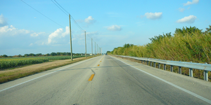
, just south of the Broward County line. Its main use is a bypass around the west side of Miami, linking the routes running southwest, west and northwest from that city, running through newer suburbs in the southern third of the road and through the edge of the everglades in the northern two thirds of the highway.
in Florida City, which provides access to the main entrance to Everglades National Park
. North of Homestead, the road passes through some suburb
an neighborhoods and farmland (primarily plant nurseries) for the next few miles. North of SR 94, the road enters Florida woodland
, and north of US 41 (Tamiami Trail), it stays on the edge of the everglades for the rest of the route until reaching its northern terminus of US 27.
State Road 205 was defined in 1931 to run from Flamingo
(now inside Everglades National Park
) northeast to State Road 4A (now U.S. Route 1) in Florida City along the Ingraham Highway. There it would run concurrent with US 1 into Homestead (US 1 ran through downtown Florida City and Homestead, instead of the bypass it uses now), splitting onto the existing Krome Avenue to end at State Road 27 (U.S. Route 94, the Tamiami Trail
, now U.S. Route 41).
In the 1945 renumbering, the State Road 27 number was assigned to all of the former State Road 205, as well as an extension north to State Road 25
(now U.S. Route 27). The large Everglades National Park
was formed in 1947, taking over most of SR 27 southwest from Florida City. Paving of this road, mostly along the old Ingraham Highway, was completed in 1956. The extension north to SR 25 opened in the early 1950s.
In the mid-1960s, State Road 5
(U.S. Route 1) was rerouted onto a bypass of Homestead and Florida City. This removed the concurrency
of SR 997 and SR 5/US 1, but the old alignment became State Road 5A
and U.S. Route 1 Business until 1968.
The SR 27 designation for Krome Avenue confused many motorists, as the SR 27 designation belonged to the nearby Tamiami Trail
(U.S. Route 41) prior to the 1945 renumbering. Tamiami Trail was still labeled as SR 27 on maps for several years following 1945. In later decades, motorists confused Krome Avenue for Okeechobee Road, which carried the similarly numbered U.S. Route 27 since 1949.
In 1983, the Florida Department of Transportation
renumbered the road as a part of a statewide renumbering and to avoid state road number confusion. The part north of Florida City became State Road 997, which was extended south past the turnoff for the Everglades to merge with U.S. Route 1. The part southwest from Florida City became State Road 9336
, and at some point it was extended east two blocks past SR 997 to US 1.
Since the late 1960s, plans to incorporate the southern portion of Krome Avenue into Miami-Dade County's system of expressways have been repeatedly announced and killed. The original plans for the Homestead Extension of Florida's Turnpike
incorporated a continuation from the southwest end of the current State Road 874
southwest to Krome Avenue, then southward to Homestead. When the proposal was defeated in 1971, the Turnpike Extension was rerouted to the present-day configuration.
and Homestead
, as the people living in those areas express their fear of increasing traffic changing the rural character of their neighborhoods.
.
State highway
State highway, state road or state route can refer to one of three related concepts, two of them related to a state or provincial government in a country that is divided into states or provinces :#A...
in western Miami-Dade County, Florida
Miami-Dade County, Florida
Miami-Dade County is a county located in the southeastern part of the state of Florida. As of 2010 U.S. Census, the county had a population of 2,496,435, making it the most populous county in Florida and the eighth-most populous county in the United States...
. It runs from U.S. Route 1 (State Road 5
State Road 5 (Florida)
State Road 5 is a mostly-unsigned state highway in the state of Florida. It is mainly signed as U.S. Route 1 from its south end in Key West, Florida to Jacksonville, Florida, and U.S. Route 17 from Jacksonville to the Georgia state line at the Saint Marys River. U.S...
) just south of Florida City north across U.S. Route 41 (State Road 90) to U.S. Route 27 (State Road 25
State Road 25 (Florida)
State Road 25 is a state highway in the U.S. state of Florida.It is mainly signed as U.S. Highways:*U.S. Highway 27 from Miami to Lady Lake and Belleview to Ocala*U.S. Highway 301 from Belleview to near Sparr...
) near Opa-locka West Airport
Opa-locka West Airport
Opa-locka West Airport was a county-owned public airport located 12 miles northwest of the central business district of Miami, a city in Miami-Dade County, Florida, United States...
, just south of the Broward County line. Its main use is a bypass around the west side of Miami, linking the routes running southwest, west and northwest from that city, running through newer suburbs in the southern third of the road and through the edge of the everglades in the northern two thirds of the highway.
Route description
State Road 997 begins at the south end of Florida City at US 1, and goes north through in the Florida City and Homestead business districts, intersecting with State Road 9336State Road 9336 (Florida)
State Road 9336 is a two- to four-lane road in the U.S. state of Florida. The route is the only signed four digit state route in Florida. The route connects the Homestead Extension of Florida's Turnpike and US 1 with the Everglades National Park SR 9336 is the primary mode of entrance to the...
in Florida City, which provides access to the main entrance to Everglades National Park
Everglades National Park
Everglades National Park is a national park in the U.S. state of Florida that protects the southern 25 percent of the original Everglades. It is the largest subtropical wilderness in the United States, and is visited on average by one million people each year. It is the third-largest...
. North of Homestead, the road passes through some suburb
Suburb
The word suburb mostly refers to a residential area, either existing as part of a city or as a separate residential community within commuting distance of a city . Some suburbs have a degree of administrative autonomy, and most have lower population density than inner city neighborhoods...
an neighborhoods and farmland (primarily plant nurseries) for the next few miles. North of SR 94, the road enters Florida woodland
Woodland
Ecologically, a woodland is a low-density forest forming open habitats with plenty of sunlight and limited shade. Woodlands may support an understory of shrubs and herbaceous plants including grasses. Woodland may form a transition to shrubland under drier conditions or during early stages of...
, and north of US 41 (Tamiami Trail), it stays on the edge of the everglades for the rest of the route until reaching its northern terminus of US 27.
History
State Road 205 was defined in 1931 to run from Flamingo
Flamingo, Florida
Flamingo is an unincorporated community and ghost town in Monroe County, Florida, United States. It began as a small coastal settlement on the eastern end of Cape Sable on the southern tip of the Florida peninsula, facing Florida Bay...
(now inside Everglades National Park
Everglades National Park
Everglades National Park is a national park in the U.S. state of Florida that protects the southern 25 percent of the original Everglades. It is the largest subtropical wilderness in the United States, and is visited on average by one million people each year. It is the third-largest...
) northeast to State Road 4A (now U.S. Route 1) in Florida City along the Ingraham Highway. There it would run concurrent with US 1 into Homestead (US 1 ran through downtown Florida City and Homestead, instead of the bypass it uses now), splitting onto the existing Krome Avenue to end at State Road 27 (U.S. Route 94, the Tamiami Trail
Tamiami Trail
The Tamiami Trail is the southernmost of U.S. Highway 41 from State Road 60 in Tampa to U.S. Route 1 in Miami. The road also has the hidden designation of State Road 90....
, now U.S. Route 41).
In the 1945 renumbering, the State Road 27 number was assigned to all of the former State Road 205, as well as an extension north to State Road 25
State Road 25 (Florida)
State Road 25 is a state highway in the U.S. state of Florida.It is mainly signed as U.S. Highways:*U.S. Highway 27 from Miami to Lady Lake and Belleview to Ocala*U.S. Highway 301 from Belleview to near Sparr...
(now U.S. Route 27). The large Everglades National Park
Everglades National Park
Everglades National Park is a national park in the U.S. state of Florida that protects the southern 25 percent of the original Everglades. It is the largest subtropical wilderness in the United States, and is visited on average by one million people each year. It is the third-largest...
was formed in 1947, taking over most of SR 27 southwest from Florida City. Paving of this road, mostly along the old Ingraham Highway, was completed in 1956. The extension north to SR 25 opened in the early 1950s.
In the mid-1960s, State Road 5
State Road 5 (Florida)
State Road 5 is a mostly-unsigned state highway in the state of Florida. It is mainly signed as U.S. Route 1 from its south end in Key West, Florida to Jacksonville, Florida, and U.S. Route 17 from Jacksonville to the Georgia state line at the Saint Marys River. U.S...
(U.S. Route 1) was rerouted onto a bypass of Homestead and Florida City. This removed the concurrency
Concurrency (road)
A concurrency, overlap, or coincidence in a road network is an instance of one physical road bearing two or more different highway, motorway, or other route numbers...
of SR 997 and SR 5/US 1, but the old alignment became State Road 5A
State Road 5A (Florida)
State Road 5A, also known as Nova Road, is a north south highway that begins and ends at U.S. Highway 1 , in Port Orange and Ormond Beach, respectively...
and U.S. Route 1 Business until 1968.
The SR 27 designation for Krome Avenue confused many motorists, as the SR 27 designation belonged to the nearby Tamiami Trail
Tamiami Trail
The Tamiami Trail is the southernmost of U.S. Highway 41 from State Road 60 in Tampa to U.S. Route 1 in Miami. The road also has the hidden designation of State Road 90....
(U.S. Route 41) prior to the 1945 renumbering. Tamiami Trail was still labeled as SR 27 on maps for several years following 1945. In later decades, motorists confused Krome Avenue for Okeechobee Road, which carried the similarly numbered U.S. Route 27 since 1949.
In 1983, the Florida Department of Transportation
Florida Department of Transportation
The Florida Department of Transportation is a decentralized agency charged with the establishment, maintenance, and regulation of public transportation in the state of Florida. The department was formed in 1969. It absorbed the powers of the Florida State Road Department...
renumbered the road as a part of a statewide renumbering and to avoid state road number confusion. The part north of Florida City became State Road 997, which was extended south past the turnoff for the Everglades to merge with U.S. Route 1. The part southwest from Florida City became State Road 9336
State Road 9336 (Florida)
State Road 9336 is a two- to four-lane road in the U.S. state of Florida. The route is the only signed four digit state route in Florida. The route connects the Homestead Extension of Florida's Turnpike and US 1 with the Everglades National Park SR 9336 is the primary mode of entrance to the...
, and at some point it was extended east two blocks past SR 997 to US 1.
Since the late 1960s, plans to incorporate the southern portion of Krome Avenue into Miami-Dade County's system of expressways have been repeatedly announced and killed. The original plans for the Homestead Extension of Florida's Turnpike
Homestead Extension of Florida's Turnpike
Homestead Extension of Florida's Turnpike , designated as the Ronald Reagan Turnpike, and originally known as the West Dade Expressway is a north–south free-flow toll road southern extension of the tolled Florida's Turnpike...
incorporated a continuation from the southwest end of the current State Road 874
State Road 874 (Florida)
State Road 874, also known as the Don Shula Expressway, is an electronic toll road extending , connecting the Homestead Extension of Florida's Turnpike and SR 826 in central Miami-Dade County, Florida. Despite its even number designation, the divided limited access toll road runs...
southwest to Krome Avenue, then southward to Homestead. When the proposal was defeated in 1971, the Turnpike Extension was rerouted to the present-day configuration.
Future
As traffic demands grow on the increasingly dangerous Krome Avenue, so do intentions to widen the north–south state highway. A chorus of disapproval has arisen from RedlandRedland, Florida
Redland, sometimes pluralized The Redlands, is an agricultural community in metropolitan Miami, Florida, United States, about southwest of Downtown Miami. Many farms, original clapboard homes of early settlers, u-pick'em fields and coral rock walls dot the landscape. It is named for the red clay...
and Homestead
Homestead, Florida
Homestead is a city in Miami-Dade County, Florida, United States nestled between Biscayne National Park to the east and Everglades National Park to the west. Homestead is primarily a Miami suburb and a major agricultural area....
, as the people living in those areas express their fear of increasing traffic changing the rural character of their neighborhoods.
Junction list
The entire route is located in Miami-Dade CountyMiami-Dade County, Florida
Miami-Dade County is a county located in the southeastern part of the state of Florida. As of 2010 U.S. Census, the county had a population of 2,496,435, making it the most populous county in Florida and the eighth-most populous county in the United States...
.
| Location | Mile | Destination | Notes |
|---|---|---|---|
| Florida City Florida City, Florida Florida City is a city in Miami-Dade County, Florida, United States and is the southernmost municipality in the South Florida metropolitan area, which had an estimated population of 5,413,212 in 2007. The population was 7,843 at the 2000 census. As of 2004, the population estimated by the U.S.... |
0.00 | Southern terminus | |
| 0.79 | |||
| Aladdin City Aladdin City, Florida Aladdin City is an unincorporated community in Miami-Dade County, Florida, United States. It is located about southwest of Miami within the unincorporated community of Redland... |
9.92 | ||
| Kendale Lakes Kendale Lakes, Florida Kendale Lakes is a census-designated place Miami suburb in Miami-Dade County, Florida, United States. The population was 56,901 at the 2000 census.-Geography:Kendale Lakes is located at .... |
17.48 | ||
| Sweetwater | 22.49 | ||
| 36.83 | Northern terminus |