
.gif)
State Highway 43 (Oklahoma)
Encyclopedia
State Highway 43 is a state highway
in Oklahoma
, USA. It runs 65.3 miles west-to-east through Coal
, Atoka
, Pushmataha
and Pittsburg
counties.
 SH-43 begins at US-75/SH-3 in Coalgate
, the seat of Coal County
. It runs east from Coalgate for 11 miles (17.7 km) toward US-69. Before meeting US-69, it crosses into Atoka County
and over Atoka Reservoir. Two boat ramps on the reservoir are accessible from SH-43. After crossing the reservoir, SH-43 reaches US-69, which it begins a concurrency
with.
US-69 and SH-43 head south, passing through Flora, an unincorporated place, and in between Atoka Reservoir and Sub-Penitentiary Lake. The two highways pass to the west of Grants Gap before reaching Stringtown
. There, SH-43 splits off to the east, leaving US-69 five miles (8 km) south of where the two highways first joined.
At Stringtown, SH-43 turns back to the east, paralleling Chickasaw Creek south of Grants Gap. The highway runs along the southern edge of the Atoka Wildlife Management Area west of unincorporated Redden. SH-43 has an interchange with the Indian Nation Turnpike
, 19 miles (30.6 km) east of Stringtown. The diamond interchange
, Exit 38 from the turnpike, carries the destination cities of Stringtown and Daisy. Daisy
lies just east of the turnpike on SH-43.
East of Daisy, SH-43 passes just north of unincorporated Goss, then crosses into Pushmataha County
. Turkey Mountain is just south of the highway as it enters the county. The route travels through the Jackfork Creek basin, a low area between the Jack Fork Mountains and the Big Caney Mountains. After passing through another unincorporated place, Adel
, the highway cuts across the far southeast corner of Pittsburg County
.
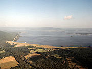
SH-43 re-enters Pushmataha County southwest of the far south arm of Sardis Lake
, a reservoir formed by impounding Jackfork Creek. The highway runs along the south shore of the lake. At the southwest corner of the lake, SH-43 runs across the top of the lake's dam. Northeast of the dam, the highway intersects SH-2. This intersection is the highway's eastern terminus.
State highway
State highway, state road or state route can refer to one of three related concepts, two of them related to a state or provincial government in a country that is divided into states or provinces :#A...
in Oklahoma
Oklahoma
Oklahoma is a state located in the South Central region of the United States of America. With an estimated 3,751,351 residents as of the 2010 census and a land area of 68,667 square miles , Oklahoma is the 28th most populous and 20th-largest state...
, USA. It runs 65.3 miles west-to-east through Coal
Coal County, Oklahoma
Coal County is a county located in the U.S. state of Oklahoma. As of 2000, the population is 6,031. Its county seat is Coalgate.-Geography:According to the U.S. Census Bureau, the county has a total area of , of which is land and is water....
, Atoka
Atoka County, Oklahoma
Atoka County is a county located in the U.S. state of Oklahoma, and was formed in 1907 from Choctaw Lands. As of 2000, the population is 13,879. Its county seat is Atoka.-Geography:...
, Pushmataha
Pushmataha County, Oklahoma
-Administrative History:* Ca. 1000-1500: Caddoan Mississippian civilization at Spiro Mounds* 1492-1718: Spain* 1718-1763: France* 1763-1800: Spain* 1800-1803: France* 1803–present: United States...
and Pittsburg
Pittsburg County, Oklahoma
Pittsburg County is a county located in the U.S. state of Oklahoma. As of 2000, the population was 43,953. Its county seat is McAlester.-Geography:According to the U.S. Census Bureau, the county has a total area of 3,569 km²...
counties.
Route description
Coalgate, Oklahoma
Coalgate is a city in and the county seat of Coal County, Oklahoma, United States. The population was 2,005 at the 2000 census.Morris W. Turner , a businessman and the mayor of Lubbock, Texas, from 1972–1974, was born in Coalgate.-Geography:...
, the seat of Coal County
Coal County, Oklahoma
Coal County is a county located in the U.S. state of Oklahoma. As of 2000, the population is 6,031. Its county seat is Coalgate.-Geography:According to the U.S. Census Bureau, the county has a total area of , of which is land and is water....
. It runs east from Coalgate for 11 miles (17.7 km) toward US-69. Before meeting US-69, it crosses into Atoka County
Atoka County, Oklahoma
Atoka County is a county located in the U.S. state of Oklahoma, and was formed in 1907 from Choctaw Lands. As of 2000, the population is 13,879. Its county seat is Atoka.-Geography:...
and over Atoka Reservoir. Two boat ramps on the reservoir are accessible from SH-43. After crossing the reservoir, SH-43 reaches US-69, which it begins a concurrency
Concurrency (road)
A concurrency, overlap, or coincidence in a road network is an instance of one physical road bearing two or more different highway, motorway, or other route numbers...
with.
US-69 and SH-43 head south, passing through Flora, an unincorporated place, and in between Atoka Reservoir and Sub-Penitentiary Lake. The two highways pass to the west of Grants Gap before reaching Stringtown
Stringtown, Oklahoma
Stringtown is a town in Atoka County, Oklahoma, United States. The population was 396 at the 2000 census. It is the second largest town in Atoka County.-Geography:Stringtown is located at ....
. There, SH-43 splits off to the east, leaving US-69 five miles (8 km) south of where the two highways first joined.
At Stringtown, SH-43 turns back to the east, paralleling Chickasaw Creek south of Grants Gap. The highway runs along the southern edge of the Atoka Wildlife Management Area west of unincorporated Redden. SH-43 has an interchange with the Indian Nation Turnpike
Indian Nation Turnpike
The Indian Nation Turnpike is a toll road in southeastern Oklahoma. It is the longest tollway in the state.-Route description:The Indian Nation turnpike is built to parkway-like design standards, omitting a center barrier and left-hand shoulders for a slightly mounded grassy median that is flush...
, 19 miles (30.6 km) east of Stringtown. The diamond interchange
Diamond interchange
A diamond interchange is a common type of road junction, used where a freeway crosses a minor road. The freeway itself is grade-separated from the minor road, one crossing the other over a bridge...
, Exit 38 from the turnpike, carries the destination cities of Stringtown and Daisy. Daisy
Daisy, Oklahoma
Daisy is a small unincorporated community in Atoka County, Oklahoma, United States, along State Highway 43. Located in the northeastern part of the county, Daisy was once a thriving community with a general store, school and other institutions. The post office was opened April 5, 1906...
lies just east of the turnpike on SH-43.
East of Daisy, SH-43 passes just north of unincorporated Goss, then crosses into Pushmataha County
Pushmataha County, Oklahoma
-Administrative History:* Ca. 1000-1500: Caddoan Mississippian civilization at Spiro Mounds* 1492-1718: Spain* 1718-1763: France* 1763-1800: Spain* 1800-1803: France* 1803–present: United States...
. Turkey Mountain is just south of the highway as it enters the county. The route travels through the Jackfork Creek basin, a low area between the Jack Fork Mountains and the Big Caney Mountains. After passing through another unincorporated place, Adel
Adel, Oklahoma
Adel is a community in northwestern Pushmataha County, Oklahoma, 12 miles west of Clayton, Oklahoma. Using the Public Land Survey System commonly in use in Oklahoma its coordinates are T13-3S-R16E....
, the highway cuts across the far southeast corner of Pittsburg County
Pittsburg County, Oklahoma
Pittsburg County is a county located in the U.S. state of Oklahoma. As of 2000, the population was 43,953. Its county seat is McAlester.-Geography:According to the U.S. Census Bureau, the county has a total area of 3,569 km²...
.
SH-43 re-enters Pushmataha County southwest of the far south arm of Sardis Lake
Sardis Lake (Oklahoma)
Sardis Lake is a reservoir in Pushmataha County and Latimer County in Oklahoma, USA. The dam impounding the lake is located approximately north of Clayton. The lake covers with of shoreline. The lake is an impoundment of Jackfork Creek, a tributary of the Kiamichi River.The lake's normal pool...
, a reservoir formed by impounding Jackfork Creek. The highway runs along the south shore of the lake. At the southwest corner of the lake, SH-43 runs across the top of the lake's dam. Northeast of the dam, the highway intersects SH-2. This intersection is the highway's eastern terminus.