
Standesamt Kolmar
Encyclopedia
Standesamt Kolmar was a civil registration district (Standesamt
) located in Kreis Kolmar
, province of Posen
of the German Empire
(1871–1918) and administered the communities of:
Kol (S) = Kolmar (town); Kol (L) = Kolmar (rural area); Usc = Usch
Population data may be inaccurate (see German census of 1895
).
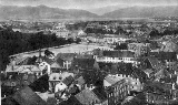
The area around Kolmar was hilly and forested, sometimes called the "Switzerland of Posen". Three lakes surround the town. The Standesamt region also included the area north of the hills, encompassing the Netze river farming communities. This area probably contains the greatest elevation difference of the entire province, from about 200 meters above sea level to about 40 meters.
The area was a major crossroads for both vehicle and rail. The railroad from Posen to Schneidemühl passed through Kolmer north/south and a line branched off to the east along the river bluff and then dipped south to Margonin, then back east to Gollantsh and points east. Major roads followed the same routes, except the east road continued along the bluff to Samotschin, and it had a western route, towards Czarnikau.
Like many other Posen communities, weaving was a major cottage industry until tariffs and industrialization made it unprofitable. A substantial ceramics (especially majolica
) factory operated northwest of Kolmar for many years.
Majolica artist Gerda Conitz was born in Studsin, 1901
Standesamt
A Standesamt is a German civil registration office, which is responsible for recording births, marriages and deaths....
) located in Kreis Kolmar
Kreis Kolmar in Posen
Kreis Kolmar was one of several Kreise in the northern administrative district of Bromberg, in the Prussian province of Posen.- Table of Standesämter :...
, province of Posen
Province of Posen
The Province of Posen was a province of Prussia from 1848–1918 and as such part of the German Empire from 1871 to 1918. The area was about 29,000 km2....
of the German Empire
German Empire
The German Empire refers to Germany during the "Second Reich" period from the unification of Germany and proclamation of Wilhelm I as German Emperor on 18 January 1871, to 1918, when it became a federal republic after defeat in World War I and the abdication of the Emperor, Wilhelm II.The German...
(1871–1918) and administered the communities of:
| Community | Polish name | Type | 1895 Pop | Prot | Cath | Jew | Civil Ofc | Police Ofc | Court Ofc | Cath. Ch | Prot. Ch | Notes | More |
| Kolmar | Chodzież Chodziez Chodzież is a town in northwestern Poland with 20,400 inhabitants . Situated in the Chodzież County, Greater Poland Voivodeship , previously in Piła Voivodeship .-Geography:... |
Town | 3567 | 1849 | 1280 | 437 | Kol (S) | Kol | Kol | Kol | Kol |
| Augustenau | Augustynowo / Wymyslaw | 232 | 175 | 57 | |||||||
| Borken Mühl | Borka | ||||||||||
| Buczkowo | Village | 199 | 152 | 47 | Kol (L) | Kol | Kol | Kol | Kol | ||
| Chodschesen, Schloß | Chodzieski Zamek | Village | 72 | 45 | 16 | 11 | Kol (L) | Kol | Kol | Kol | Kol |
| Chodschesen, Stadtmühle | Miejski Mlyn | Estate | 47 | 31 | 16 | Kol (L) | Kol | Kol | Kol | Kol | |
| Helmsgrün | Estate | 59 | 51 | 8 | Kol (L) | Kol | Kol | Kol | Kol | ||
| Kamionke | Kamionka | Village | 123 | 108 | 15 | Kol (L) | Kol | Kol | Kol | Kol | |
| Krumke Neuwerder | Village | 328 | 240 | 88 | Kol (L) | Kol | Kol | Kol | Kol | ||
| Milsch | Village | 350 | 274 | 76 | Kol (L) | Kol | Kol | Kol | Kol | ||
| Nikolskowo | Estate | 442 | 168 | 274 | Kol (L) | Usc | Kol | Usc | Kol | ||
| Nikolskowo | Village | 264 | 58 | 206 | Kol (L) | Usc | Kol | Usc | Kol | ||
| Ober Lesnitz | Olesnica | Estate | 652 | 375 | 277 | Kol (L) | Kol | Kol | Kol | Kol | |
| Pietronke | Pietronki | Estate | 333 | 170 | 163 | Kol (L) | Kol | Kol | Kol | Kol | |
| Pietronke | Pietronki | Village | 30 | 20 | 10 | Kol (L) | Kol | Kol | Kol | Kol | |
| Rattai | Rataje | Village | 274 | 186 | 88 | Kol (L) | Kol | Kol | Kol | Kol | |
| Rattai | Rataje | Estate | 109 | 66 | 43 | Kol (L) | Kol | Kol | Kol | Kol | |
| Schütz Haus | |||||||||||
| Studsin | Studzieniec | Village | 273 | 246 | 27 | Kol (L) | Kol | Kol | Kol | Kol | |
| Wilsbach | Village | 82 | 23 | 59 | Kol (L) | Kol | Kol | Kol, Usc | Kol | ||
| Unter Lesnitz | Zamkowy Folwark / Babiadziura | ||||||||||
Kol (S) = Kolmar (town); Kol (L) = Kolmar (rural area); Usc = Usch
Population data may be inaccurate (see German census of 1895
German census of 1895
The German census of 1895 was one of the first full-scale German censuses, organized on all territories of the German Empire.Prior to 1871 many German counties organized various local census records, however most of the results did not survive World War II...
).
The area around Kolmar was hilly and forested, sometimes called the "Switzerland of Posen". Three lakes surround the town. The Standesamt region also included the area north of the hills, encompassing the Netze river farming communities. This area probably contains the greatest elevation difference of the entire province, from about 200 meters above sea level to about 40 meters.
The area was a major crossroads for both vehicle and rail. The railroad from Posen to Schneidemühl passed through Kolmer north/south and a line branched off to the east along the river bluff and then dipped south to Margonin, then back east to Gollantsh and points east. Major roads followed the same routes, except the east road continued along the bluff to Samotschin, and it had a western route, towards Czarnikau.
Like many other Posen communities, weaving was a major cottage industry until tariffs and industrialization made it unprofitable. A substantial ceramics (especially majolica
Delftware
Delftware, or Delft pottery, denotes blue and white pottery made in and around Delft in the Netherlands and the tin-glazed pottery made in the Netherlands from the 16th century....
) factory operated northwest of Kolmar for many years.
External links
Majolica artist Gerda Conitz was born in Studsin, 1901