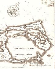
St. George's Island, Bermuda
Encyclopedia

Bermuda
Bermuda is a British overseas territory in the North Atlantic Ocean. Located off the east coast of the United States, its nearest landmass is Cape Hatteras, North Carolina, about to the west-northwest. It is about south of Halifax, Nova Scotia, Canada, and northeast of Miami, Florida...
. It lies in the northeast of the territory. It is divided between the town of St. George's
St. George's, Bermuda
St. George's , located on the island and within the parish of the same names, was the first permanent settlement on the islands of Bermuda, and is often described as the third successful English settlement in the Americas, after St. John's, Newfoundland, and Jamestown, Virginia. However, St...
and St. George's Parish
St. George's Parish, Bermuda
St. George's Parish is one of the nine parishes of Bermuda. It is named after the founder of the Bermuda colony, Admiral Sir George Somers.It is located in the north-easternmost part of the island chain, containing a small part of the main island around Tucker's Town and the Tucker's Town...
. The island covers 703 acres (2.8 square kilometres), and is one of the six principal islands of Bermuda.
Originally called King's Island, this was the first part of Bermuda to be extensively colonised, and the town of St. George's contains many of the territory's oldest buildings. Notable among these are St. Peter's Church, and the State House, and many forts, including Gate's Fort. Fort St. Catherine, close to the island's (and Bermuda's) northernmost point, is a 19th Century construction built upon a 17th Century base. it is were the first english settlers ship wrecked in the sea venture in 1609.
The island is separated from the nearby St. David's Island
St. David's Island, Bermuda
St. David's Island is one of the main islands of Bermuda. It is located in the far north of the territory, one of the two similarly sized islands that makeup the majority of St...
by St. George's Harbor in the north, and by a channel known as Ferry Reach
Ferry Reach, Bermuda
Ferry Reach is a three mile long channel in the north-east of Bermuda, which lies between St. George's Island in the north and St. David's Island in the south south-west of the town of St. George's.It extends south from St...
in the south. Bridges and a causeway
The Causeway, Bermuda
The Causeway is a narrow strip of reclaimed land and bridges in the north of Bermuda linking Hamilton Parish on the mainland in the southwest and Bermuda International Airport on St. David's Island in St. George's Parish in the northeast, which are otherwise divided by Castle Harbour.The need for...
connect it with the main island to the south via St. David's Island.

