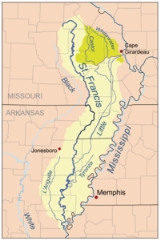
St. Francis River
Overview
Tributary
A tributary or affluent is a stream or river that flows into a main stem river or a lake. A tributary does not flow directly into a sea or ocean...
of the Mississippi River
Mississippi River
The Mississippi River is the largest river system in North America. Flowing entirely in the United States, this river rises in western Minnesota and meanders slowly southwards for to the Mississippi River Delta at the Gulf of Mexico. With its many tributaries, the Mississippi's watershed drains...
, about 426 miles (685.6 km) long, in southeastern Missouri
Missouri
Missouri is a US state located in the Midwestern United States, bordered by Iowa, Illinois, Kentucky, Tennessee, Arkansas, Oklahoma, Kansas and Nebraska. With a 2010 population of 5,988,927, Missouri is the 18th most populous state in the nation and the fifth most populous in the Midwest. It...
and northeastern Arkansas
Arkansas
Arkansas is a state located in the southern region of the United States. Its name is an Algonquian name of the Quapaw Indians. Arkansas shares borders with six states , and its eastern border is largely defined by the Mississippi River...
in the United States
United States
The United States of America is a federal constitutional republic comprising fifty states and a federal district...
. The river drains a mostly rural area and forms part of the Missouri-Arkansas state line along the western side of the Missouri bootheel
Bootheel
The Missouri Bootheel is the southeasternmost part of the state of Missouri, extending south of 36°30’ north latitude, so called because its shape in relation to the rest of the state resembles the heel of a boot. Strictly speaking, it is composed of the counties of Dunklin, New Madrid, and Pemiscot...
.
The river rises in a region of granite
Granite
Granite is a common and widely occurring type of intrusive, felsic, igneous rock. Granite usually has a medium- to coarse-grained texture. Occasionally some individual crystals are larger than the groundmass, in which case the texture is known as porphyritic. A granitic rock with a porphyritic...
mountains in Iron County, Missouri
Iron County, Missouri
Iron County is a county located in the Lead Belt region in Southeast Missouri in the United States. As of the 2000 U.S. Census, the county's population was 10,697. A 2008 estimate, however, showed the population to be 9,918. The largest city and county seat is Ironton...
, and flows generally southwardly through the Ozarks and the St. Francois Mountains near Missouri's highest point Taum Sauk.
Unanswered Questions

