

Springwood, New South Wales
Encyclopedia
Springwood is a town in the Blue Mountains, New South Wales
, Australia
. Springwood is located 72 kilometres west of Sydney
in the local government area of the City of Blue Mountains
. At the 2006 census
, Springwood had a population of 8,210 people. It is largely Anglo-Celtic.
Springwood is near the Blue Mountains National Park
and the Greater Blue Mountains Area
World Heritage Site
. It is 371 metres above sea level and, like most of the towns in the vicinity, is located on a narrow ridge between two gorges. Winmalee
is to the north. Springwood railway station sits between Valley Heights
and Faulconbridge
on the Blue Mountains railway line.
Their existence in the area dates back to approx 40,000 years of settlement with many rock carvings & art sites in the area.
At the time of settlement the Chief or the clan was Oryang Jack who was drawn by French Artist Pellier (Ref Mitchell Library)
Oryang-Ora was also the reference to the area that marked the dividing ridge line between the Darug
tribes of the north and the Gundungurra tribes to the south in the Blue Mountains area.
In 1815, Governor Lachlan Macquarie
and his wife stopped by what Macquarie called a spring. The place was later named Springwood: "Spring" from the springs in the area, and "wood" from the local Mountain Blue Gums (Eucalyptus deanei) of the area.. As a town developed, the main street was named Macquarie Road, after Governor Macquarie.
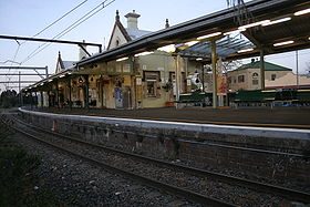
The first railway line was put through the Blue Mountains in 1867, and the Springwood station was built in 1868. This station was replaced by a more substantial building in the Victorian Gothic style, constructed in 1884 under the direction of John Whitton
, Chief Engineer of NSW Railways; a porter's cottage was constructed just west of the station. Springwood Station is the second-oldest surviving station in the Blue Mountains. It is listed on the Register of the National Estate
as well as having a New South Wales heritage listing..
In 1892, James Hunter Lawson built Braemar, a large, single-storey house situated on a sixty-acre property on Macquarie Road. Braemar started as a family residence but later became a convalescent home, a boarding house, a private home again and a guesthouse. It was acquired by the Blue Mountains City Council in 1974, restored as a Bicentennial project and reopened in 1988. It serves as a community gallery and centre, staffed by volunteers. The local library is housed in a new building behind Braemar.
Christ Church Anglican Church was built on the Great Western Highway from 1888-89. It was designed by the architect Sir John Sulman
, who had a holiday residence at Lawson
. Designed in the Victorian Academic Gothic style, the church is the centre of Anglicanism in the lower Blue Mountains and is heritage-listed.
The Presbyterian Church, a sandstone Gothic building located on Macquarie Road, was built in 1895. The Catholic community was originally part of the Penrith
parish, but were given their own building in 1892: St Thomas Aquinas Church. The church has since relocated to St Columbas grounds,Winmalee.
 Springwood's commercial area centres around Macquarie Road which runs parallel to the Great Western Highway and the railway line. Springwood railway station is on the Blue Mountains Line of the CityRail
intercity network. Blue Mountains Bus Company also makes daily trips through Springwood from Penrith & Katoomba, and also various bus routes depart Springwood for Burns Road, Springwood Hospital, Hazelbrook and Winmalee.
, Winmalee High School
and St. Columba's High School
. Springwood in also serviced by four primary schools: Ellison Public School, Faulconbridge Public School, Springwood Public School and St Thomas Aquinas Primary School.
Parade. The Blue Mountains Vietnam Veterans' Association conducts the largest annual parade and Memorial Service for Vietnam veterans in Australasia at Springwood, on the third Sunday of August, to coincide with the anniversary of the Battle of Long Tan
.
Fairy Dell is located immediately south of the township and has some tracks leading into the Blue Mountains World Heritage area. The Deanei Reserve is another bushland area which is located east of the township and hosts the threatened and endangered Blue Mountains Shalecap Forest. There are also bushland walks in this bushland Reserve.
Buttenshaw Park is also a recreational area which hosts an arboretum, play structures and the Springwood Pool.
Summerhayes Park is a public reserve located in Winmalee, which is used for sport and recreational activities. Its facilities include tennis and netball courts, a newly built skate park and fields for Football (soccer) both local (NDSFA) and Representative (FNSW) all year round. It is the home of Springwood United Football Club (formally Springwood Soccer & Sports Club) [8] and Springwood Netball Club. Summerhayes Park has diverse native flora and fauna and contains many threatened/endangered species and ecological communities. It is also a bushwalking area with many tracks, vistas and aboriginal archeological sites.
is the home of the oldest remaining roundhouse in New South Wales, located 500 m from the eastern Springwood town boundary.
Springwood Model Railway Exhibition is held each year at St Thomas Aquinas Primary School.
New South Wales
New South Wales is a state of :Australia, located in the east of the country. It is bordered by Queensland, Victoria and South Australia to the north, south and west respectively. To the east, the state is bordered by the Tasman Sea, which forms part of the Pacific Ocean. New South Wales...
, Australia
Australia
Australia , officially the Commonwealth of Australia, is a country in the Southern Hemisphere comprising the mainland of the Australian continent, the island of Tasmania, and numerous smaller islands in the Indian and Pacific Oceans. It is the world's sixth-largest country by total area...
. Springwood is located 72 kilometres west of Sydney
Sydney
Sydney is the most populous city in Australia and the state capital of New South Wales. Sydney is located on Australia's south-east coast of the Tasman Sea. As of June 2010, the greater metropolitan area had an approximate population of 4.6 million people...
in the local government area of the City of Blue Mountains
City of Blue Mountains
The City of Blue Mountains is a local government area of New South Wales, Australia, governed by the Blue Mountains City Council. The city is located in the Blue Mountains range west of Sydney.-Demographics:...
. At the 2006 census
Census in Australia
The Australian census is administered once every five years by the Australian Bureau of Statistics. The most recent census was conducted on 9 August 2011; the next will be conducted in 2016. Prior to the introduction of regular censuses in 1961, they had also been run in 1901, 1911, 1921, 1933,...
, Springwood had a population of 8,210 people. It is largely Anglo-Celtic.
Springwood is near the Blue Mountains National Park
Blue Mountains National Park
The Blue Mountains National Park is a national park in New South Wales, Australia, 81 km west of Sydney, and located in the Blue Mountains region of the Great Dividing Range. The park covers 268,987 hectares. The boundary of the park is quite irregular as it is broken up by roads, urban areas...
and the Greater Blue Mountains Area
Greater Blue Mountains Area
The Greater Blue Mountains Area is a World Heritage Site in the Blue Mountains of New South Wales, Australia. It was inscribed on the World Heritage List at the 24th Session of the World Heritage Committee, held in Cairns from 27 November to 2 December 2000...
World Heritage Site
World Heritage Site
A UNESCO World Heritage Site is a place that is listed by the UNESCO as of special cultural or physical significance...
. It is 371 metres above sea level and, like most of the towns in the vicinity, is located on a narrow ridge between two gorges. Winmalee
Winmalee, New South Wales
Winmalee is a town in New South Wales, Australia. Winmalee is located 80 kilometres west of Sydney, in the local government area of the City of Blue Mountains. At the 2006 census, Winmalee had a population of 6,345....
is to the north. Springwood railway station sits between Valley Heights
Valley Heights, New South Wales
Valley Heights is a small township of the City of Blue Mountains in New South Wales, Australia. It is approximately from Sydney and is located east of the township of Springwood...
and Faulconbridge
Faulconbridge, New South Wales
Faulconbridge is a village located in the Blue Mountains 77 km west of Sydney, New South Wales and is 450 metres above sea level. At the 2006 census, Faulconbridge had a population of 4,014 people.-History and Description:...
on the Blue Mountains railway line.
History
The Springwood area was first occupied by the Oryang-Ora aboriginal clan belonging to the wider Darug aboriginal tribe of the wider Sydney region.Their existence in the area dates back to approx 40,000 years of settlement with many rock carvings & art sites in the area.
At the time of settlement the Chief or the clan was Oryang Jack who was drawn by French Artist Pellier (Ref Mitchell Library)
Oryang-Ora was also the reference to the area that marked the dividing ridge line between the Darug
Darug people
The Darug people are a language group of Indigenous Australians, who are traditional custodians of much of what is modern day Sydney. There is some dispute about the extent of the Darug nation. Some historians believe the coastal Eora people were a separate tribe to the Darug...
tribes of the north and the Gundungurra tribes to the south in the Blue Mountains area.
In 1815, Governor Lachlan Macquarie
Lachlan Macquarie
Major-General Lachlan Macquarie CB , was a British military officer and colonial administrator. He served as the last autocratic Governor of New South Wales, Australia from 1810 to 1821 and had a leading role in the social, economic and architectural development of the colony...
and his wife stopped by what Macquarie called a spring. The place was later named Springwood: "Spring" from the springs in the area, and "wood" from the local Mountain Blue Gums (Eucalyptus deanei) of the area.. As a town developed, the main street was named Macquarie Road, after Governor Macquarie.
The first railway line was put through the Blue Mountains in 1867, and the Springwood station was built in 1868. This station was replaced by a more substantial building in the Victorian Gothic style, constructed in 1884 under the direction of John Whitton
John Whitton
John Whitton was appointed Engineer-in-Charge for the New South Wales Railways, Australia, in January 1867. Over the next 32 years he completed 2811 miles of railway around NSW and Victoria...
, Chief Engineer of NSW Railways; a porter's cottage was constructed just west of the station. Springwood Station is the second-oldest surviving station in the Blue Mountains. It is listed on the Register of the National Estate
Register of the National Estate
The Register of the National Estate is a listing of natural and cultural heritage places in Australia. The listing was initially compiled between 1976 and 2003 by the Australian Heritage Commission. The register is now maintained by the Australian Heritage Council...
as well as having a New South Wales heritage listing..
In 1892, James Hunter Lawson built Braemar, a large, single-storey house situated on a sixty-acre property on Macquarie Road. Braemar started as a family residence but later became a convalescent home, a boarding house, a private home again and a guesthouse. It was acquired by the Blue Mountains City Council in 1974, restored as a Bicentennial project and reopened in 1988. It serves as a community gallery and centre, staffed by volunteers. The local library is housed in a new building behind Braemar.
Christ Church Anglican Church was built on the Great Western Highway from 1888-89. It was designed by the architect Sir John Sulman
John Sulman
Sir John Sulman was an Australian architect. Born in Greenwich, England, he emigrated to Sydney, Australia in 1885. From 1921 to 1924 he was chairman of the Federal Capital Advisory Committee and influenced the development of Canberra.-Early life:Sulman was born in was born at Greenwich, England...
, who had a holiday residence at Lawson
Lawson, New South Wales
Lawson is a town in the Blue Mountains area of New South Wales, Australia. It is located on the Great Western Highway between Hazelbrook in the north east and Bullaburra in the west. At the 2006 census, Lawson had a population of 2,419 people. It has a station on the Main Western line...
. Designed in the Victorian Academic Gothic style, the church is the centre of Anglicanism in the lower Blue Mountains and is heritage-listed.
The Presbyterian Church, a sandstone Gothic building located on Macquarie Road, was built in 1895. The Catholic community was originally part of the Penrith
Penrith, New South Wales
Penrith is a suburb in western Sydney, in the state of New South Wales, Australia. Penrith is located west of the Sydney central business district and is the administrative centre for the local government area of the City of Penrith...
parish, but were given their own building in 1892: St Thomas Aquinas Church. The church has since relocated to St Columbas grounds,Winmalee.
Commercial area and transport
CityRail
CityRail is an operating brand of RailCorp, a corporation owned by the state government of New South Wales, Australia. It is responsible for providing commuter rail services, and some coach services, in and around Sydney, Newcastle and Wollongong, the three largest cities of New South Wales. It is...
intercity network. Blue Mountains Bus Company also makes daily trips through Springwood from Penrith & Katoomba, and also various bus routes depart Springwood for Burns Road, Springwood Hospital, Hazelbrook and Winmalee.
Education
The town is serviced by three high schools, Springwood High SchoolSpringwood High School
Springwood High School is a public high school situated in the City of Blue Mountains, New South Wales. Despite its name, geographically the school is actually in Faulconbridge. The school was established in 1967. Its motto is "Press Onward."-Description:...
, Winmalee High School
Winmalee High School
Winmalee High School is an Australian public school situated in the North of the suburb of Winmalee in the city of Blue Mountains, Australia. The School borders onto National Park which has been recently placed on the World Heritage List and surrounds the City.It was established in 1985, and...
and St. Columba's High School
St. Columba's High School
St Columba's High School is a Roman Catholic, co-educational, Secondary day school, located on the border of Winmalee and Springwood, in New South Wales, Australia....
. Springwood in also serviced by four primary schools: Ellison Public School, Faulconbridge Public School, Springwood Public School and St Thomas Aquinas Primary School.
Churches
- Springwood Anglican Church meeting at Christ Church (1888-89)
- Springwood Baptist
- Springwood Presbyterian meeting at Frazer Presbyterian Church (1895)
- Springwood Salvation Army
- Springwood Uniting Church
- St. Thomas Aquinas Catholic Church
- Lutheran Springwood
- Springwood Family Church
Climate
Springwood generally has mild winters and mild summers, but can suffer bushfire damage during the summer months. It has a rainfall of approximately 1175 mm per year.. The mean annual maximum temperature is 22°C with the mean maximum in January approximately 28°C and 18°C in July. The mean minimum temperature is 9°C (Bureau of Meteorology).Celebrations and events
The town's annual celebration, Springwood Foundation Day, occurs each April. Springwood is also the site of a notable ANZAC DayANZAC Day
Anzac Day is a national day of remembrance in Australia and New Zealand, commemorated by both countries on 25 April every year to honour the members of the Australian and New Zealand Army Corps who fought at Gallipoli in the Ottoman Empire during World War I. It now more broadly commemorates all...
Parade. The Blue Mountains Vietnam Veterans' Association conducts the largest annual parade and Memorial Service for Vietnam veterans in Australasia at Springwood, on the third Sunday of August, to coincide with the anniversary of the Battle of Long Tan
Battle of Long Tan
The Battle of Long Tân was fought between the Australian Army and Viet Cong forces in a rubber plantation near the village of Long Tân, about north east of Vũng Tàu, South Vietnam...
.
Parks and recreation
Springwood has some parklands with bushwalks often leading into wilderness areas.Fairy Dell is located immediately south of the township and has some tracks leading into the Blue Mountains World Heritage area. The Deanei Reserve is another bushland area which is located east of the township and hosts the threatened and endangered Blue Mountains Shalecap Forest. There are also bushland walks in this bushland Reserve.
Buttenshaw Park is also a recreational area which hosts an arboretum, play structures and the Springwood Pool.
Summerhayes Park is a public reserve located in Winmalee, which is used for sport and recreational activities. Its facilities include tennis and netball courts, a newly built skate park and fields for Football (soccer) both local (NDSFA) and Representative (FNSW) all year round. It is the home of Springwood United Football Club (formally Springwood Soccer & Sports Club) [8] and Springwood Netball Club. Summerhayes Park has diverse native flora and fauna and contains many threatened/endangered species and ecological communities. It is also a bushwalking area with many tracks, vistas and aboriginal archeological sites.
Tourist attractions
Valley Heights Locomotive Depot Heritage MuseumValley Heights Locomotive Depot Heritage Museum
The Valley Heights Locomotive Depot Heritage Museum is a railway museum located in Valley Heights, New South Wales, Australia. It is operated by the Blue Mountains Division of the New South Wales Rail Transport Museum....
is the home of the oldest remaining roundhouse in New South Wales, located 500 m from the eastern Springwood town boundary.
Springwood Model Railway Exhibition is held each year at St Thomas Aquinas Primary School.