

Spencer Road Halt railway station
Encyclopedia
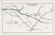
Spencer Road Halt was a railway halt on the Woodside and South Croydon Railway
, which opened in 1906. It closed on 15 March 1915.
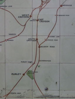
 The site of the halt is hidden in an alleyway between Spencer Road and Birdhurst Rise in South Croydon
. The railway company had hoped that this halt would enable passengers to change to the Brighton Line
by making the ten-minute walk to South Croydon station
, however very few did. Spencer Road was among several new stations and halts introduced during this period (others included Reedham
and Bandon
) in the suburban area to compete with the convenience of electric trams and to a lesser extent the early omnibuses
, whose effect was being felt on railway income particularly with regard to shorter journeys.
 Apart from a metal footbridge which carried the right-of-way between Spencer Road and Birdhurst Rise over the railway line, Spencer Road Halt consisted of nothing beyond a set of wooden platforms and nameboards. Oil lamps were also likely to have been provided. The platforms were reached from wooden gates on either side of the footbridge; a notice adjoining the gate was headed "Woodside and South Croydon Railway" and warned passengers against taking a short-cut over the railway line and instead to use the footbridge.
Spencer Road was closed in 1915 as a wartime economy, but remained physically intact until at least 1931. The remains were eventually cleared away by the Southern Railway in 1935 when it electrified and reopened the line. An Up starter signal post for Selsdon Road
made of old rails was subsequently installed on the site of the Up platform, and during the Second World War a tank trap was built on the site of the Down platform.
http://rhaworth.ucoz.net/photo/4-0-23 A view from the footbridge showing the scout hut.
Woodside and South Croydon Railway
The Woodside and South Croydon Joint Railway was a short, relatively short-lived and unsuccessful railway in the London Borough of Croydon in London, England. Its site is now largely occupied by Tramlink.- Route :- History :...
, which opened in 1906. It closed on 15 March 1915.
History
South Croydon
South Croydon is a locality in Greater London, the area surrounding the valley south of central Croydon about 1 km in radius, centred on the Red Deer public house on the Brighton Road. It is part of the South Croydon post town and in the London Borough of Croydon...
. The railway company had hoped that this halt would enable passengers to change to the Brighton Line
Brighton Main Line
The Brighton Main Line is a British railway line from London Victoria and London Bridge to Brighton. It is about 50 miles long, and is electrified throughout. Trains are operated by Southern, First Capital Connect, and Gatwick Express, now part of Southern.-Original proposals:There were no fewer...
by making the ten-minute walk to South Croydon station
South Croydon railway station
South Croydon railway station is in the London Borough of Croydon in south London, in Travelcard Zone 5. It is on the Brighton Line at its junction with the Oxted Line. The station and all trains serving it are operated by Southern.-History:...
, however very few did. Spencer Road was among several new stations and halts introduced during this period (others included Reedham
Reedham railway station (London)
Reedham station is a railway station in the south of Purley in the London Borough of Croydon on the Tattenham Corner Line. The local area is residential and the station is near the A23 Brighton Road...
and Bandon
Bandon Halt railway station
Bandon Halt was a station on the 1847 London, Brighton and South Coast Railway extension from West Croydon to Epsom. It was situated between Waddon and Wallington stations and was open between 1906 and 1914. It takes its name from the immediate area which is called Bandon Hill...
) in the suburban area to compete with the convenience of electric trams and to a lesser extent the early omnibuses
Bus
A bus is a road vehicle designed to carry passengers. Buses can have a capacity as high as 300 passengers. The most common type of bus is the single-decker bus, with larger loads carried by double-decker buses and articulated buses, and smaller loads carried by midibuses and minibuses; coaches are...
, whose effect was being felt on railway income particularly with regard to shorter journeys.
Spencer Road was closed in 1915 as a wartime economy, but remained physically intact until at least 1931. The remains were eventually cleared away by the Southern Railway in 1935 when it electrified and reopened the line. An Up starter signal post for Selsdon Road
Selsdon railway station
Selsdon railway station was on the Croydon, Oxted and East Grinstead Railway and the now-closed Woodside and South Croydon Railway. Opened in 1885 as "Selsdon Road", it was two miles from Selsdon village...
made of old rails was subsequently installed on the site of the Up platform, and during the Second World War a tank trap was built on the site of the Down platform.
Present day
The station has been demolished although its footbridge remains in use. As of 2008 the double track on the line was still in situ but heavily overgrown. The nearby underbridge crossing the Croham Road is also extant.http://rhaworth.ucoz.net/photo/4-0-23 A view from the footbridge showing the scout hut.
External links
- Article at Subterranea Britannica with several images