
South Mountains State Park
Encyclopedia
South Mountains State Park is a North Carolina state park in Burke County
, North Carolina
in the United States
. Located near Connellys Springs, North Carolina
, it covers 16,664 acres (67 km²) and includes part of the South Mountains
, a branch of the Blue Ridge Mountains
.
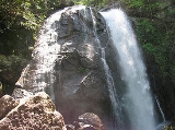
High Shoals Falls
is the centerpiece of the park.
by erosion, are a broad belt of peaks and knobs rising abruptly from a deep valley. These steep, rugged mountains encompass 100,000 acres (404 km²) in Burke, Cleveland and Rutherford counties.
The Catawba Valley and the gaps across the mountain ranges to the west were once major travel routes. The South Mountains served as a buffer zone between the Cherokee and the Catawba Indians, and the first European settlers in the area farmed the fertile land along the Catawba River.
In 1828, gold was discovered at Brindle Creek. Legend holds that gold flakes and grains were first discovered in the mud used to seal a log cabin. The ensuing gold rush attracted immigrants, mining companies and slave owners. Gold was mined into the early 20th century, but activity in the gold mines eventually declined. Development of land in what is now South Mountains State Park began in the 1930s when Camp Dryer, a Civilian Conservation Corps
(CCC) camp, was established at Enola. Those employed at the camp constructed forest service roads, cleaned stream beds and built a forest observation tower. The Lower and Upper CCC roads are still in use at the park today.
The park was established as a result of recommendations made by a National Park Service study conducted in coordination with the state of North Carolina. Though proposals for the park began in the 1940s, it was not until 1974 that funds were appropriated to purchase the land. The first land acquisition totaled 5779 (23.39 km²) acres. Additional land has since been added, bringing the park to its present size of 16,664 acres (67.44 km²).
While most of the high points average approximately 2000 feet (609 m) in elevation, Buzzard's Roost towers some 3000 feet (914 m) above the surrounding landscape. Elevations within the park itself range from less than convert 1200 feet (365 m) at points along Jacob's Fork River to 3,000 feet (914 m) on Buzzard's Roost along the park's western boundary.
Water winding through the park to the Catawba River cuts deep into the terrain, forming rugged and steep slopes. The most spectacular feature in the park is High Shoals Falls
on Jacob's Fork River. Here, a torrent of water drops 80 feet (24 m) over a cliff face of bare rock. In addition, Chestnut Knob offers tranquility and a magnificent view of surrounding peaks and ridges.
Burke County, North Carolina
-Demographics:As of the census of 2000, there were 89,148 people, 34,528 households, and 24,342 families residing in the county. The population density was 176 people per square mile . There were 37,427 housing units at an average density of 74 per square mile...
, North Carolina
North Carolina
North Carolina is a state located in the southeastern United States. The state borders South Carolina and Georgia to the south, Tennessee to the west and Virginia to the north. North Carolina contains 100 counties. Its capital is Raleigh, and its largest city is Charlotte...
in the United States
United States
The United States of America is a federal constitutional republic comprising fifty states and a federal district...
. Located near Connellys Springs, North Carolina
Connellys Springs, North Carolina
Connelly Springs is a town in Burke County, North Carolina, United States. The population was 1,814 at the 2000 census. It is part of the Hickory–Lenoir–Morganton Metropolitan Statistical Area.-Geography:...
, it covers 16,664 acres (67 km²) and includes part of the South Mountains
South Mountains (North Carolina)
The South Mountains are an ancient and deeply eroded mountain range in western North Carolina. They are an isolated remnant of the much larger Appalachian Mountains to the west, and are separated from the Appalachians by the Catawba River valley. The range covers approximately 100,000 acres in...
, a branch of the Blue Ridge Mountains
Blue Ridge Mountains
The Blue Ridge Mountains are a physiographic province of the larger Appalachian Mountains range. This province consists of northern and southern physiographic regions, which divide near the Roanoke River gap. The mountain range is located in the eastern United States, starting at its southern-most...
.
High Shoals Falls
High Shoals Falls
High Shoals Falls is a waterfall in Burke County, North Carolina.-Geology:The waterfall is on the Jacob's Fork River, flowing over a large rock outcropping in the South Mountains of North Carolina...
is the centerpiece of the park.
History
The South Mountains, carved out of the Blue RidgeBlue Ridge Mountains
The Blue Ridge Mountains are a physiographic province of the larger Appalachian Mountains range. This province consists of northern and southern physiographic regions, which divide near the Roanoke River gap. The mountain range is located in the eastern United States, starting at its southern-most...
by erosion, are a broad belt of peaks and knobs rising abruptly from a deep valley. These steep, rugged mountains encompass 100,000 acres (404 km²) in Burke, Cleveland and Rutherford counties.
The Catawba Valley and the gaps across the mountain ranges to the west were once major travel routes. The South Mountains served as a buffer zone between the Cherokee and the Catawba Indians, and the first European settlers in the area farmed the fertile land along the Catawba River.
In 1828, gold was discovered at Brindle Creek. Legend holds that gold flakes and grains were first discovered in the mud used to seal a log cabin. The ensuing gold rush attracted immigrants, mining companies and slave owners. Gold was mined into the early 20th century, but activity in the gold mines eventually declined. Development of land in what is now South Mountains State Park began in the 1930s when Camp Dryer, a Civilian Conservation Corps
Civilian Conservation Corps
The Civilian Conservation Corps was a public work relief program that operated from 1933 to 1942 in the United States for unemployed, unmarried men from relief families, ages 18–25. A part of the New Deal of President Franklin D...
(CCC) camp, was established at Enola. Those employed at the camp constructed forest service roads, cleaned stream beds and built a forest observation tower. The Lower and Upper CCC roads are still in use at the park today.
The park was established as a result of recommendations made by a National Park Service study conducted in coordination with the state of North Carolina. Though proposals for the park began in the 1940s, it was not until 1974 that funds were appropriated to purchase the land. The first land acquisition totaled 5779 (23.39 km²) acres. Additional land has since been added, bringing the park to its present size of 16,664 acres (67.44 km²).
While most of the high points average approximately 2000 feet (609 m) in elevation, Buzzard's Roost towers some 3000 feet (914 m) above the surrounding landscape. Elevations within the park itself range from less than convert 1200 feet (365 m) at points along Jacob's Fork River to 3,000 feet (914 m) on Buzzard's Roost along the park's western boundary.
Water winding through the park to the Catawba River cuts deep into the terrain, forming rugged and steep slopes. The most spectacular feature in the park is High Shoals Falls
High Shoals Falls
High Shoals Falls is a waterfall in Burke County, North Carolina.-Geology:The waterfall is on the Jacob's Fork River, flowing over a large rock outcropping in the South Mountains of North Carolina...
on Jacob's Fork River. Here, a torrent of water drops 80 feet (24 m) over a cliff face of bare rock. In addition, Chestnut Knob offers tranquility and a magnificent view of surrounding peaks and ridges.