
Sound of Arisaig
Encyclopedia
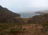
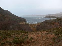
The Sound of Arisaig in Lochaber
, Scotland
, separates the Arisaig
peninsula to the north from the Moidart
peninsula to the south. At the eastern, landward end, the sound is divided by Ardnish into two sea lochs. Loch nan Uamh lies to the north of Ardnish, Loch Ailort
to the south. There are a number of small islands in the sound, of which Eilean nan Gobhar and Samalaman Island, both near to Glenuig
on the south shore, are the largest.
 The A830 road
, called the Road to the Isles, runs along the east end of Loch Ailort, and then crosses Ardnish before turning westwards along the north shore of Loch nan Uamh and the sound proper. The West Highland Line
follows the same route. The A861 road
follows the south shore of Loch Ailort and the sound proper as far west as Glenuig.
The Prince's Cairn
, marking the spot where Bonnie Prince Charlie finally left Scotland after the unsuccessful Jacobite Rising of 1745, on 20 September 1746, overlooks Loch nan Uamh.
The sound is a marine Special Area of Conservation
.
Lochaber
District of Lochaber 1975 to 1996Highland council area shown as one of the council areas of ScotlandLochaber is one of the 16 ward management areas of the Highland Council of Scotland and one of eight former local government districts of the two-tier Highland region...
, Scotland
Scotland
Scotland is a country that is part of the United Kingdom. Occupying the northern third of the island of Great Britain, it shares a border with England to the south and is bounded by the North Sea to the east, the Atlantic Ocean to the north and west, and the North Channel and Irish Sea to the...
, separates the Arisaig
Arisaig
Arisaig is a village in Lochaber, Invernessshire, on the west coast of the Scottish Highlands.-History:On 20 September 1746 Bonnie Prince Charlie left Scotland for France from a place near the village following the failure of the Jacobite Rising. The site of his departure is marked by the Prince's...
peninsula to the north from the Moidart
Moidart
Moidart is a district in Lochaber, Highland, Scotland.Moidart lies to the west of Fort William and is very remote. Loch Shiel cuts off the south-east boundary of the district. Moidart includes the townships of Dorlin, Mingarry, Kinlochmoidart and Glenuig. At Dorlin is located the ancient fortress...
peninsula to the south. At the eastern, landward end, the sound is divided by Ardnish into two sea lochs. Loch nan Uamh lies to the north of Ardnish, Loch Ailort
Loch Ailort
Loch Ailort is a sea loch loch in Morar, Lochaber, Highland, Scotland. Loch Ailort is a shallow V shaped loch, with the small Ardnish Peninsula on the north side, and the large southwest facing Moidart Peninsula to the south...
to the south. There are a number of small islands in the sound, of which Eilean nan Gobhar and Samalaman Island, both near to Glenuig
Glenuig
Glenuig is a small village in Moidart, Lochaber, Highland, on the west coast of Scotland. It is around 30 miles west of Fort William and 20 miles from Ardnamurchan Point.-Geography:...
on the south shore, are the largest.
A830 road
The A830, sometimes known as the Road to the Isles , is a road in Lochaber, in the Highlands of Scotland, which connects the town of Fort William to the port of Mallaig....
, called the Road to the Isles, runs along the east end of Loch Ailort, and then crosses Ardnish before turning westwards along the north shore of Loch nan Uamh and the sound proper. The West Highland Line
West Highland Line
The West Highland Line is considered the most scenic railway line in Britain, linking the ports of Mallaig and Oban on the west coast of Scotland to Glasgow. The line was voted the top rail journey in the world by readers of independent travel magazine Wanderlust in 2009, ahead of the iconic...
follows the same route. The A861 road
A861 road
The A861 road is a circuitous, primarily coastal, road in Highland, Scotland.The A861 serves the communities of the remote Ardgour, Sunart, Moidart and Ardnamurchan areas Although the ends of this road are only fourteen miles apart its total length is seventy miles.Route *junction with the A830...
follows the south shore of Loch Ailort and the sound proper as far west as Glenuig.
The Prince's Cairn
Prince's Cairn
The Prince's Cairn is a cairn at Loch nan Uamh in Lochaber, Scotland.On 19 September 1746, Charles Edward Stuart arrived from "Cluny's Cage", that refuge on Ben Alder, accompanied by Donald Cameron of Lochiel, , and others. There they found L'Heureux, the French frigate that was to carry him to...
, marking the spot where Bonnie Prince Charlie finally left Scotland after the unsuccessful Jacobite Rising of 1745, on 20 September 1746, overlooks Loch nan Uamh.
The sound is a marine Special Area of Conservation
Special Area of Conservation
A Special Area of Conservation is defined in the European Union's Habitats Directive , also known as the Directive on the Conservation of Natural Habitats and of Wild Fauna and Flora...
.
External links
- The Sound of Arisaig Marine Special Area of Conservation
- Panorama of the Sound of Arisaig (QuickTime required)