
Sokobanjska Moravica
Encyclopedia

Serbian language
Serbian is a form of Serbo-Croatian, a South Slavic language, spoken by Serbs in Serbia, Bosnia and Herzegovina, Montenegro, Croatia and neighbouring countries....
Cyrillic: Сокобањска Моравица or Моравица) is a river in central eastern Serbia
Serbia
Serbia , officially the Republic of Serbia , is a landlocked country located at the crossroads of Central and Southeast Europe, covering the southern part of the Carpathian basin and the central part of the Balkans...
, a 58 km-long right tributary to the Južna Morava
Južna Morava
South Morava or in the past Bulgarian Morava is a river in the Republic of Macedonia and Serbia which represents the shorter headwater of Great Morava...
river.
Devica and Ozren mountains
The Sokobanjska Moravica originates from the eastern slopes of the DevicaDevica
Devica is a mountain in eastern Serbia, near the town of Sokobanja. Its highest peak, Čapljinac has an altitude of 1187 metres above sea level...
mountain, near the village of Skrobnica. The river flows to the north, turns westward at the village of Levovik and enters the Banja region. The rivers flows between the northern slopes of the Devica and Ozren
Ozren (Sokobanja)
Ozren is a mountain in central Serbia, near the town of Sokobanja. Its highest peak Leskovik has an altitude of 1174 meters above sea level. Ozren is well-forested and attractive as a picnic ground for visitors to the Soko spa....
mountains (on the south) and southern slopes of the Rtanj
Rtanj
Rtanj is a village in the municipality of Boljevac, Serbia. According to the 2002 census, the village has a population of 182 people.-References:...
mountain (on the north), next to the villages of Čitluk
Citluk
Čitluk is a town and municipality located in Herzegovina, in southern Bosnia and Herzegovina. It is a municipality of the Herzegovina-Neretva Canton in the Federation of Bosnia and Herzegovina....
(including a coal mine), Vrela and Blendija, reaching the town of Sokobanja
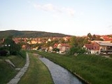
Sokobanja
Sokobanja is a well-known spa town and municipality situated in eastern Serbia.-Population:In 2011 the population of the Sokobanja town is 7,972, while population of the whole municipality is 15,981...
, a center of Sokobanja depression and of the whole Banja region.
Bovan
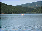
Velika Morava
The Great Morava is the final section of the Morava , a major river system in Serbia.- Length :...
river regulation. Artificial Bovan lake flooded the Bovan gorge carved by the river and is very popular local and regional tourist destination, especially among campers and fishermen, but the coastline is not put in order. The river continues to the south, in an inverse
Inverse
Inverse may refer to:* Inverse , a type of immediate inference from a conditional sentence* Inverse , a program for solving inverse and optimization problems...
flow, and after the villages of Subotinac and Kraljevo, it empties into the Južna Morava at the town of Aleksinac
Aleksinac
Aleksinac is a town which is a center of Aleksinac Municipality, located in the Nišava District of Serbia. According to 2011 census, the town has a population of 16,420 inhabitants, while the municipality has 51,462.-Name:...
. The lower section used to be a coal mining area too, just like the upper one, but the mines (Aleksinački Rudnik
Aleksinacki Rudnik
Aleksinački Rudnik is a town in Serbia. It is situated in the municipality of Aleksinac, in the Nišava District. The population of the town is 1,467 people ....
) are closed now.
The Sokobanjska Moravica brlongs to the Black Sea
Black Sea
The Black Sea is bounded by Europe, Anatolia and the Caucasus and is ultimately connected to the Atlantic Ocean via the Mediterranean and the Aegean seas and various straits. The Bosphorus strait connects it to the Sea of Marmara, and the strait of the Dardanelles connects that sea to the Aegean...
drainage basin
Drainage basin
A drainage basin is an extent or an area of land where surface water from rain and melting snow or ice converges to a single point, usually the exit of the basin, where the waters join another waterbody, such as a river, lake, reservoir, estuary, wetland, sea, or ocean...
, drains an area of 606 km² itself, and it is not navigable.