

Soil series
Encyclopedia
National Cooperative Soil Survey
The National Cooperative Soil Survey in the United States is a nation-wide partnership of federal, regional, state, and local agencies and institutions...
of the United States Department of Agriculture (USDA)
United States Department of Agriculture
The United States Department of Agriculture is the United States federal executive department responsible for developing and executing U.S. federal government policy on farming, agriculture, and food...
Natural Resources Conservation Service
Natural Resources Conservation Service
The Natural Resources Conservation Service , formerly known as the Soil Conservation Service , is an agency of the United States Department of Agriculture that provides technical assistance to farmers and other private landowners and managers.Its name was changed in 1994 during the Presidency of...
are a level of classification in the USDA Soil Taxonomy
USDA soil taxonomy
USDA Soil Taxonomy developed by United States Department of Agriculture and the National Cooperative Soil Survey provides an elaborate classification of soil types according to several parameters and in several levels: Order, Suborder, Great Group, Subgroup, Family, and Series.- Example of...
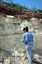
classification system hierarchy. The actual object of classification is the so-called soil individual, or pedon. Soil series consist of pedons that are grouped together because of their similar pedogenesis
Pedogenesis
Pedogenesis is the science and study of the processes that lead to the formation of soil ' and first explored by the Russian geologist Vasily Dokuchaev , the so called grandfather of soil science, who determined that soil formed over time as a consequence of...
, soil chemistry
Soil chemistry
Soil chemistry is the study of the chemical characteristics of soil. Soil chemistry is affected by mineral composition, organic matter and environmental factors.-History:...
, and physical properties. More specifically, each series consists of pedons having soil horizons that are similar in soil color
Soil color
Soil colour does not affect the behavior and use of soil, however it can indicate the composition of the soil and give clues to the conditions that the soil is subjected to....
, soil texture
Soil texture
Soil texture is a qualitative classification tool used in both the field and laboratory to determine classes for agricultural soils based on their physical texture. The classes are distinguished in the field by the 'textural feel' which can be further clarified by separating the relative...
, soil structure
Soil structure
Soil structure is determined by how individual soil granules clump or bind together and aggregate, and therefore, the arrangement of soil pores between them...
, soil pH
Soil pH
The soil pH is a measure of the acidity or basicity in soils. pH is defined as the negative logarithm of the activity of hydrogen ions in solution. It ranges from 0 to 14, with 7 being neutral. A pH below 7 is acidic and above 7 is basic. Soil pH is considered a master variable in soils as it...
, consistence, mineral and chemical composition, and arrangement in the soil profile . These result in soils which perform similarly for land use
Land use
Land use is the human use of land. Land use involves the management and modification of natural environment or wilderness into built environment such as fields, pastures, and settlements. It has also been defined as "the arrangements, activities and inputs people undertake in a certain land cover...
purposes.
The soil series concept was originally introduced in 1903. Soil series were originally intended to consist of groups of soils which were thought to be the same in origin but different in texture. Soils were thought to be alike in origin if they were derived from the same kind of rocks or if they were derived in sediments derived from the same kind of rocks and deposited at the same time.
A soil series name generally is derived from a town or landmark in or near the area where the soil series was first recognized . For example, the Haugan Series was first identified near Haugan, Montana
Haugan, Montana
Haugan is an unincorporated community in Mineral County, Montana, United States. Haugan is situated east of the Idaho border and west of Missoula on Interstate 90 at the Haugan Exit #16....
. The distribution of a given series is not necessarily restricted to the boundaries of only one county or state—for example, the Hagerstown Series was first described near Hagerstown, Maryland
Hagerstown, Maryland
Hagerstown is a city in northwestern Maryland, United States. It is the county seat of Washington County, and, by many definitions, the largest city in a region known as Western Maryland. The population of Hagerstown city proper at the 2010 census was 39,662, and the population of the...
, but has also been found as far away as Tennessee
Tennessee
Tennessee is a U.S. state located in the Southeastern United States. It has a population of 6,346,105, making it the nation's 17th-largest state by population, and covers , making it the 36th-largest by total land area...
and Kentucky
Kentucky
The Commonwealth of Kentucky is a state located in the East Central United States of America. As classified by the United States Census Bureau, Kentucky is a Southern state, more specifically in the East South Central region. Kentucky is one of four U.S. states constituted as a commonwealth...
.
Relationship to soil mapping
Depending on the context, a soil series may be defined as either a taxonomic unit or a mapping unit. A taxonomic unit is a category belonging to a specific level of a classification system. It is a conceptual entity that describes the "central nucleus" or essential characteristics of a class. On the other hand, a mapping unit delineates areas of soil in the landscape (i.e. adjacent pedons or polypedons) that possess similar characteristics. The characteristics of a soil series (taxonomic unit) may or may not overlap either fully or partially with the characteristics of pedons within a given mapping unit.Mapping units consist of one or more components. Each component represents polypedons that belong to a particular soil series. The name of a map unit is usually named after the dominant component within the mapping unit . For example, the dominant component of the mapping unit LhE—Lily sandy loam, 15 to 35 percent slopes, very stony in the Greenbrier County, West Virginia
Greenbrier County, West Virginia
As of the census of 2000, there were 34,453 people, 14,571 households, and 9,922 families residing in the county. The population density was 34 people per square mile . There were 17,644 housing units at an average density of 17 per square mile...
soil survey is the Lily series, which comprises 80% of the mapping unit. The remaining 20% of the mapping unit consists of the Dekalb series, Berks series, and "soils that have stones covering less of the surface" than the Lily series .