
Soil Moisture Active and Passive mission
Encyclopedia
The Soil Moisture Active Passive mission (SMAP) is in the first tier of missions recommended for NASA
by the Earth Science Decadal Survey. It is one of the first Earth observation satellites being developed by NASA
in response to the National Research Council
’s Decadal Survey. It has been selected for launch in November 2014.
1) Understand processes that link the terrestrial water, energy and carbon cycle
s; 2) Estimate global water and energy fluxes at the land surface; 3) Quantify net carbon flux in boreal landscapes; 4) Enhance weather and climate forecast skill; 5) Develop improved flood prediction and drought monitoring capability.
SMAP observations will be acquired for a period of at least three years after launch. A comprehensive validation, science, and applications program will be implemented, and all data will be made available publicly through the NASA
archive centers.
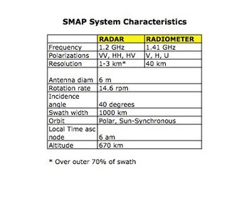
The SMAP measurement system consists of a radiometer
(passive) instrument and a synthetic aperture radar
(active) instrument operating with multiple polarizations in the L-band range (1.20-1.41 GHz).
The active and passive sensors provide coincident measurements of the surface emission and backscatter. The instruments sense conditions in the top 5 cm of soil through moderate vegetation cover to yield globally mapped estimates of soil moisture and its freeze-thaw state. The combined active and passive measurement approach takes advantage of the spatial resolution of the radar
and the sensing accuracy of the radiometer
.
with a target launch date in November 2014. The SMAP project is managed for NASA
by the Jet Propulsion Laboratory JPL, with participation by the Goddard Space Flight Center GSFC. SMAP builds on the heritage and risk reduction activities of NASA
's ESSP Hydros Mission.
models and seasonal climate models with accurate soil moisture information will extend forecast lead times and enhance prediction skill.
conditions, enabling new capabilities for mitigating drought
impacts.
forecasts and will provide essential information on the potential for landslides.
forecasts and will enhance the capabilities of crop water stress decision support systems for agricultural productivity
.
early warning systems. Benefits will also be realized through improved predictions of heat stress and virus
spread rates, and improved disaster preparation and response.
NASA
The National Aeronautics and Space Administration is the agency of the United States government that is responsible for the nation's civilian space program and for aeronautics and aerospace research...
by the Earth Science Decadal Survey. It is one of the first Earth observation satellites being developed by NASA
NASA
The National Aeronautics and Space Administration is the agency of the United States government that is responsible for the nation's civilian space program and for aeronautics and aerospace research...
in response to the National Research Council
United States National Research Council
The National Research Council of the USA is the working arm of the United States National Academies, carrying out most of the studies done in their names.The National Academies include:* National Academy of Sciences...
’s Decadal Survey. It has been selected for launch in November 2014.
Mission overview
SMAP will provide measurements of the land surface soil moisture and freeze-thaw state with near-global revisit coverage in 2–3 days. SMAP surface measurements will be coupled with hydrologic models to infer soil moisture conditions in the root zone. These measurements will enable science applications users to:1) Understand processes that link the terrestrial water, energy and carbon cycle
Carbon cycle
The carbon cycle is the biogeochemical cycle by which carbon is exchanged among the biosphere, pedosphere, geosphere, hydrosphere, and atmosphere of the Earth...
s; 2) Estimate global water and energy fluxes at the land surface; 3) Quantify net carbon flux in boreal landscapes; 4) Enhance weather and climate forecast skill; 5) Develop improved flood prediction and drought monitoring capability.
SMAP observations will be acquired for a period of at least three years after launch. A comprehensive validation, science, and applications program will be implemented, and all data will be made available publicly through the NASA
NASA
The National Aeronautics and Space Administration is the agency of the United States government that is responsible for the nation's civilian space program and for aeronautics and aerospace research...
archive centers.
Measurement concept
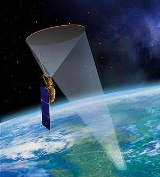
The SMAP observatory includes a dedicated spacecraft and instrument suite that will be launched into a near-polar, sun-synchronous orbit on an expendable launch vehicle.The SMAP measurement system consists of a radiometer
Radiometer
A radiometer is a device for measuring the radiant flux of electromagnetic radiation. Generally, the term radiometer denotes an infrared radiation detector, yet it also includes detectors operating on any electromagnetic wavelength....
(passive) instrument and a synthetic aperture radar
Radar
Radar is an object-detection system which uses radio waves to determine the range, altitude, direction, or speed of objects. It can be used to detect aircraft, ships, spacecraft, guided missiles, motor vehicles, weather formations, and terrain. The radar dish or antenna transmits pulses of radio...
(active) instrument operating with multiple polarizations in the L-band range (1.20-1.41 GHz).
The active and passive sensors provide coincident measurements of the surface emission and backscatter. The instruments sense conditions in the top 5 cm of soil through moderate vegetation cover to yield globally mapped estimates of soil moisture and its freeze-thaw state. The combined active and passive measurement approach takes advantage of the spatial resolution of the radar
Radar
Radar is an object-detection system which uses radio waves to determine the range, altitude, direction, or speed of objects. It can be used to detect aircraft, ships, spacecraft, guided missiles, motor vehicles, weather formations, and terrain. The radar dish or antenna transmits pulses of radio...
and the sensing accuracy of the radiometer
Radiometer
A radiometer is a device for measuring the radiant flux of electromagnetic radiation. Generally, the term radiometer denotes an infrared radiation detector, yet it also includes detectors operating on any electromagnetic wavelength....
.
System characteristics
The radar and radiometer share a single feed and deployable mesh reflector antenna system (diameter 6 m) that rotates around the nadir axis making conical scans of the surface. The wide swath provides near-global revisit 2–3 days.Program description
SMAP is a directed mission of the National Aeronautics and Space Administration NASANASA
The National Aeronautics and Space Administration is the agency of the United States government that is responsible for the nation's civilian space program and for aeronautics and aerospace research...
with a target launch date in November 2014. The SMAP project is managed for NASA
NASA
The National Aeronautics and Space Administration is the agency of the United States government that is responsible for the nation's civilian space program and for aeronautics and aerospace research...
by the Jet Propulsion Laboratory JPL, with participation by the Goddard Space Flight Center GSFC. SMAP builds on the heritage and risk reduction activities of NASA
NASA
The National Aeronautics and Space Administration is the agency of the United States government that is responsible for the nation's civilian space program and for aeronautics and aerospace research...
's ESSP Hydros Mission.
Science and applications
SMAP observations will be used to characterize hydrologic and ecosystem processes including land-atmosphere exchanges of water, energy, and carbon. SMAP soil moisture and freeze-thaw information will directly benefit several societal applications areas, including:Weather and climate forecasting
Initialization of numerical weather predictionNumerical weather prediction
Numerical weather prediction uses mathematical models of the atmosphere and oceans to predict the weather based on current weather conditions. Though first attempted in the 1920s, it was not until the advent of computer simulation in the 1950s that numerical weather predictions produced realistic...
models and seasonal climate models with accurate soil moisture information will extend forecast lead times and enhance prediction skill.
Drought
SMAP soil moisture information will improve the monitoring and forecasting of droughtDrought
A drought is an extended period of months or years when a region notes a deficiency in its water supply. Generally, this occurs when a region receives consistently below average precipitation. It can have a substantial impact on the ecosystem and agriculture of the affected region...
conditions, enabling new capabilities for mitigating drought
Drought
A drought is an extended period of months or years when a region notes a deficiency in its water supply. Generally, this occurs when a region receives consistently below average precipitation. It can have a substantial impact on the ecosystem and agriculture of the affected region...
impacts.
Floods and landslides
Hydrologic forecast systems calibrated and initialized with high-resolution soil moisture fields will lead to improved floodFlood
A flood is an overflow of an expanse of water that submerges land. The EU Floods directive defines a flood as a temporary covering by water of land not normally covered by water...
forecasts and will provide essential information on the potential for landslides.
Agricultural productivity
Soil moisture observations from SMAP will lead to improvements in crop yieldCrop yield
In agriculture, crop yield is not only a measure of the yield of cereal per unit area of land under cultivation, yield is also the seed generation of the plant itself...
forecasts and will enhance the capabilities of crop water stress decision support systems for agricultural productivity
Agricultural productivity
Agricultural productivity is measured as the ratio of agricultural outputs to agricultural inputs. While individual products are usually measured by weight, their varying densities make measuring overall agricultural output difficult...
.
Human health
Improved seasonal soil moisture forecasts will directly benefit famineFamine
A famine is a widespread scarcity of food, caused by several factors including crop failure, overpopulation, or government policies. This phenomenon is usually accompanied or followed by regional malnutrition, starvation, epidemic, and increased mortality. Every continent in the world has...
early warning systems. Benefits will also be realized through improved predictions of heat stress and virus
Virus
A virus is a small infectious agent that can replicate only inside the living cells of organisms. Viruses infect all types of organisms, from animals and plants to bacteria and archaea...
spread rates, and improved disaster preparation and response.