

Skoparnik
Encyclopedia
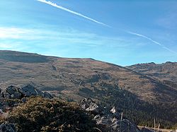
Vitosha
Vitosha is a mountain massif, on the outskirts of Sofia, the capital of Bulgaria. Vitosha is one of the tourists symbols of Sofia and the closest site for hiking, alpinism and skiing. Convenient bus lines and rope ways render the mountain easily accessible. Vitosha has the outlines of an enormous...
in Bulgaria
Bulgaria
Bulgaria , officially the Republic of Bulgaria , is a parliamentary democracy within a unitary constitutional republic in Southeast Europe. The country borders Romania to the north, Serbia and Macedonia to the west, Greece and Turkey to the south, as well as the Black Sea to the east...
. Rising to 2,226 m, the peak is situated 1.5 km south of Golyam Rezen
Golyam Rezen
Golyam Rezen is a peak on Vitosha Mountain in Bulgaria. Rising to 2,277 m, the peak is second to the mountain's summit Cherni Vrah situated 900 m to the west. Golyam Rezen hosts an Air Traffic Services facility, as well as military communications installations...
Peak (2,277 m), and 2 km southeast of the summit Cherni Vrah
Cherni Vrah
Cherni Vrah is the summit of Vitosha Mountain in Bulgaria. Rising to 2290 m, the peak is the fourth highest mountain summit in the country after Musala , Vihren , and Botev Vrah .Cherni Vrah is bounded to the northwest by Torfeno Branishte which — like the extensive adjacent...
(2,290 m). The peak is bounded by the Bistrishko Branishte
Bistrishko Branishte
Bistrishko Branishte is a nature reserve on Vitosha Mountain in Bulgaria comprising the eastern slopes of Golyam Rezen , Malak Rezen and Skoparnik Peaks, the northern slopes of Golyam Kupen Peak , and the upper valleys of Vitoshka Bistritsa River and Yanchevska River...
Biosphere Reserve
Biosphere reserve
The Man and the Biosphere Programme of UNESCO was established in 1971 to promote interdisciplinary approaches to management, research and education in ecosystem conservation and sustainable use of natural resources.-Development:...
to the east, and a prohibited drinking water catchment area
Drainage basin
A drainage basin is an extent or an area of land where surface water from rain and melting snow or ice converges to a single point, usually the exit of the basin, where the waters join another waterbody, such as a river, lake, reservoir, estuary, wetland, sea, or ocean...
to the west, and is part of the divide between the Black Sea
Black Sea
The Black Sea is bounded by Europe, Anatolia and the Caucasus and is ultimately connected to the Atlantic Ocean via the Mediterranean and the Aegean seas and various straits. The Bosphorus strait connects it to the Sea of Marmara, and the strait of the Dardanelles connects that sea to the Aegean...
and the Mediterranean, with the Vitoshka Bistritsa
Vitoshka Bistritsa
Bistritsa or Vitoshka Bistritsa , is a river in western Bulgaria, tributary of Iskar River. Flows from the eastern slopes of Golyam Rezen Peak on Vitosha Mountain, crossing Bistrishko Branishte Nature Reserve, where it forms a small but beautiful waterfall Samokovishteto, then crossing villages of...
draining its eastern slopes to flow into the Iskar River
Iskar
The Iskar is, with a length of 368 km, the longest river that runs solely in Bulgaria, and a tributary of the Danube.The Iskar is formed by three rivers, the Cherni Iskar, Beli Iskar and Levi Iskar , with the source being accepted to be the Prav Iskar, a tributary of the Cherni Iskar...
and eventually to the Danube River
Danube
The Danube is a river in the Central Europe and the Europe's second longest river after the Volga. It is classified as an international waterway....
, and the Struma River
Struma
The Struma was a ship chartered to carry Jewish refugees from Axis-allied Romania to British-controlled Palestine during World War II. On February 23, 1942, with its engine inoperable and its refugee passengers aboard, Turkish authorities towed the ship from Istanbul harbor through the Bosphorus...
draining the western slopes to flow into the Aegean Sea
Aegean Sea
The Aegean Sea[p] is an elongated embayment of the Mediterranean Sea located between the southern Balkan and Anatolian peninsulas, i.e., between the mainlands of Greece and Turkey. In the north, it is connected to the Marmara Sea and Black Sea by the Dardanelles and Bosporus...
.
The peak is accessible by tracks coming from Golyam Rezen
Golyam Rezen
Golyam Rezen is a peak on Vitosha Mountain in Bulgaria. Rising to 2,277 m, the peak is second to the mountain's summit Cherni Vrah situated 900 m to the west. Golyam Rezen hosts an Air Traffic Services facility, as well as military communications installations...
Peak in the north; from Aleko Centre
Aleko, Vitosha
Aleko is a site on Vitosha Mountain in Bulgaria situated at the northern foothills of Malak Rezen Peak , in the watershed of Yanchevska River draining eastwards towards the village of Bistritsa, Sofia....
or Bistritsa
Bistritsa, Sofia
Bistritsa or Bistrica is a large village in the Pancharevo municipality, located at 15 km to the south of the capital Sofia. it has 4,004 inhabitants....
via the upper Bistrishko Branishte; from Zheleznitsa Village in the east; and from Chuypetlovo
Chuypetlovo
Chuypetlovo is a village in the Pernik municipality of Pernik Province, western Bulgaria. Its population is 57 as of January 2007.Chuypetlovo is the only settlement in the interior of Vitosha Mountain, situated at elevation 1,225 m near the head of Struma River valley...
and Yarlovo
Yarlovo
Yarlovo is village in Samokov municipality of Sofia Province in South-West Bulgaria. It is located 24 kilometers away from Sofia. Located on the West slope of the Vitosha mountain massif, the altitude exceeds 1000 meters. The village has over 500 inhabitants....
Villages in the southwest and south.
Skoparnik Bluff
Skoparnik Bluff
Skoparnik Bluff is the partly ice-free bluff rising to over 700 m in the northeast foothills of Detroit Plateau on Trinity Peninsula in Graham Land, Antarctica...
on Trinity Peninsula
Trinity Peninsula
Trinity Peninsula is the extreme northern portion of the Antarctic Peninsula, extending northeastward for about from a line connecting Cape Kjellman and Cape Longing. Dating back more than a century, chartmakers used various names for this portion of the Antarctic peninsula, each name having some...
in Antarctica is named after the peak.