Sirikot
Encyclopedia
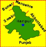
Sirikot, a word derived from Sir-i-Koh, meaning the top of the hill, is one of the 44 union councils
of Haripur District
, in the Khyber Pakhtunkhwa province of Pakistan
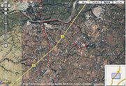
. It is located at 34°10'60N 73°43'50E in Ghazi Tehsil
- Sirikot village is the principle settlement of the Union Council.
To the west of Haripur Tehsil there is another very beautiful and populous village of the Mashwani's known as Gudwalian (Goodvalley), it is located between Haripur city and Sirikot(Ghazi). It is between 12–14 km from Haripur and is the site of a well known Mosque - the "Ali Masjid". A majority of the population of Sirikot and Gudwallian (Goodvalley) is Pashto speaking, commonly known as Mashwani, a tribe of Syed
from Syed Banda Nawaz, famous as Baba Gaisu Daraz who married a lady from Pathan tribe of Kakar. The Hindko speaking community, which is the dominant community in Haripur District overall, is the second major population in this area.
valleys due to the cloudiness. In winter, temperatures are cold, with minima in January around 0°C (32°F) and much lower in the high mountains. Snowfalls are not uncommon even at lower levels.
Hazara lies close to the crossroads formed by the river Indus and the Grand Trunk Road
. The Karakoram Highway
begins at the town of Havelian and goes north through the division towards China
via the Northern Areas. While, the Sirikot village is a mountainous area lying towards the west of Haripur District on West of Tarbela Dam. The nearest Union Council to this is Kundi-Umarkhana, which have Mashwani population in Majority as Sirikot towards Tarbela (Ghazi) side. On the other hand, Gudwalian another populated area of Mashwanis lies towards land area of Haripur city. The climate of Sirikot is better than Haripur on average due to its hilly location on the upper range of Tarbela.
 The area is populated by the Pashto speaking people as their mother tongue, and some others also speak Hindko as their mother tongue. Pashto (which forms a majority in the rest of the province) is predominant in Sirikot, 95% of the population of Sirikot speaks Pashto while most of the remaining speak Hindko. Syed and Mashwani are the major tribe in Sirikot while Awan, Gujjars and few others also live here.
The Mashwani population of Sirikot was around 50,000 out of total 85,000 of Gujjars from Garhan and Bail area and central village Awan tribes as estimated in 2005.
Union Councils of Pakistan
A sherwan or village council in Pakistan is an elected local government body consisting of 21 councillors, and headed by a nazim and a naib nazim...
of Haripur District
Haripur District
Haripur is a district in the Hazara region of Khyber-Pukhtunkhwa, province of Pakistan with an altitude of around above sea level. Haripur District has the highest Human Development Index of all the districts in the Hazara....
, in the Khyber Pakhtunkhwa province of Pakistan
Pakistan
Pakistan , officially the Islamic Republic of Pakistan is a sovereign state in South Asia. It has a coastline along the Arabian Sea and the Gulf of Oman in the south and is bordered by Afghanistan and Iran in the west, India in the east and China in the far northeast. In the north, Tajikistan...
. It is located at 34°10'60N 73°43'50E in Ghazi Tehsil
Ghazi Tehsil
Ghazi Tehsil is an administrative subdivision of Haripur District in the Khyber Pakhtunkhwa province of Pakistan. The tehsil, headquartered at the town of Ghazi, is itself subdivided into 7 Union Councils.-References:...
- Sirikot village is the principle settlement of the Union Council.
To the west of Haripur Tehsil there is another very beautiful and populous village of the Mashwani's known as Gudwalian (Goodvalley), it is located between Haripur city and Sirikot(Ghazi). It is between 12–14 km from Haripur and is the site of a well known Mosque - the "Ali Masjid". A majority of the population of Sirikot and Gudwallian (Goodvalley) is Pashto speaking, commonly known as Mashwani, a tribe of Syed
Syed
Syed is a masculine given name derived from the title Sayyid, it is not to be confused with the similar looking name Sayid...
from Syed Banda Nawaz, famous as Baba Gaisu Daraz who married a lady from Pathan tribe of Kakar. The Hindko speaking community, which is the dominant community in Haripur District overall, is the second major population in this area.
Geography and climate
Due to the high altitude, temperatures in Hazara are cooler than on the plains, though Abbottabad at 1200 metres (3,937 ft) still has maxima around 32°C (90°F) with high humidity in June and July. Further up, temperatures are cooler, often cooler than the Northern AreasNorthern Areas
Gilgit-Baltistan , is the northernmost political entity within Pakistan. It borders Pakistan's Khyber Pukhtunkhwa province to the west, Afghanistan's Wakhan Corridor to the north, China to the east and northeast, Azad Kashmir to the southwest, and Indian-administered Jammu and Kashmir to the...
valleys due to the cloudiness. In winter, temperatures are cold, with minima in January around 0°C (32°F) and much lower in the high mountains. Snowfalls are not uncommon even at lower levels.
Hazara lies close to the crossroads formed by the river Indus and the Grand Trunk Road
Grand Trunk Road
The Grand Trunk Road also formerly known as Uttarapatha, Shah Rah-e-Azam or Sadak-e-Azam or Badshahi Sadak is one of South Asia's oldest and longest major roads...
. The Karakoram Highway
Karakoram Highway
The Karakoram Highway is the highest paved international road in the world, but at its peak at the China-Pakistan border it is only paved on the Chinese side. It connects China and Pakistan across the Karakoram mountain range, through the Khunjerab Pass, at an altitude of as confirmed by both...
begins at the town of Havelian and goes north through the division towards China
China
Chinese civilization may refer to:* China for more general discussion of the country.* Chinese culture* Greater China, the transnational community of ethnic Chinese.* History of China* Sinosphere, the area historically affected by Chinese culture...
via the Northern Areas. While, the Sirikot village is a mountainous area lying towards the west of Haripur District on West of Tarbela Dam. The nearest Union Council to this is Kundi-Umarkhana, which have Mashwani population in Majority as Sirikot towards Tarbela (Ghazi) side. On the other hand, Gudwalian another populated area of Mashwanis lies towards land area of Haripur city. The climate of Sirikot is better than Haripur on average due to its hilly location on the upper range of Tarbela.
Population
The population of the Sirikot Union Council is around 85,000 estimated in 2005. The total area of Hazara is 18013 km²: See table below.Demographics and society

Villages in Union Council Sirikot
Aram Dara, Shatalu Sharief, Sirikot Kalay, Botigram, Gallai, Ghundheray, Sirikot, Serai, Billah, Chountrai, Shanai, Chinarkot, Khairooch, Baghoona, Duraha, Damraha, Kotkay, Pulhari, Damkay, Bugnia, Kukarchaha, Bail, Garhan, Dheri,Sanger, Jabba choi kihari and others.Sub tribes
The sub tribes of Mashwani residing in the area are sub-sections of the Mashwani include:Manikhel,Jalal Khail,Sahib Khail,Sen Khail (Moolhan), Dura Khail, Bhatal,Haseen Khail,Wares khail, Wahdet khail, Baji Khel, Ludin, Matkani, Roghani, Ganjiyan, Murjankhel, , Janikhel, Rahatkhel, Senkhael.The Mashwani population of Sirikot was around 50,000 out of total 85,000 of Gujjars from Garhan and Bail area and central village Awan tribes as estimated in 2005.

