

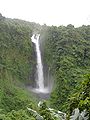
Siri Waterfall
Encyclopedia
Waterfall
A waterfall is a place where flowing water rapidly drops in elevation as it flows over a steep region or a cliff.-Formation:Waterfalls are commonly formed when a river is young. At these times the channel is often narrow and deep. When the river courses over resistant bedrock, erosion happens...
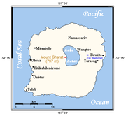
located about 3 km inland from the eastern coast of the island of Gaua
Gaua
Gaua is the largest of the Banks Islands in Torba Province of northern Vanuatu. It covers 342 km².- Physical geography :...
in northern Vanuatu
Vanuatu
Vanuatu , officially the Republic of Vanuatu , is an island nation located in the South Pacific Ocean. The archipelago, which is of volcanic origin, is some east of northern Australia, northeast of New Caledonia, west of Fiji, and southeast of the Solomon Islands, near New Guinea.Vanuatu was...
.
The supply of water to the waterfall is from Lake Letas
Lake Letas
Lake Letas is the largest lake in Vanuatu, located in the center of the volcanic island of Gaua of the Banks Islands in northern Vanuatu. The place submitted an application to be considered an UNESCO World Heritage Site in 2004....
. This lake is a large freshwater lake located in the crater at the centre of the volcanic island, about 600 meters above sea level. Water flows from the lake 3 km east to the top of Siri Waterfall. After the waterfall, the water flows as a large stream, called Mbe Solomul River (formerly Namang), for another 3 km before it reaches the sea. The large stream is known as "Big Water".
A rough estimate of the water flow rate (during the dry season month of August 2006) was approximately 5 cubic metres per second.