
Shoals, Indiana
Encyclopedia
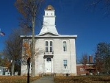
Shoals is a town in Center
and Halbert
townships, Martin County
, Indiana
, United States
. The population was 756 at the 2010 census. The city is the county seat
of Martin County
.
Shoals is best known for the Jug Rock
, the only free-standing table rock formation East of the Mississippi River
. The Shoals Catfish Festival is held annually on the July 4th holiday weekend.
took place at the county courthouse and jail. The Archer boys were accused of torturing and killing a local farmer and were hung from trees in front of the jail in 1886.
Shoals is also known for making mother of pearl buttons during the early 20th-century. They were made out of mussels from the White River
.
According to the United States Census Bureau
, the town has a total area of 1.9 square miles (4.9 km²), of which, 1.8 square miles (4.7 km²) of it is land and 0.1 square mile (0.258998811 km²) of it (5.26%) is water.
of 2000, there were 807 people, 377 households, and 214 families residing in the town. The population density
was 448.0 people per square mile (173.1/km²). There were 420 housing units at an average density of 233.1 per square mile (90.1/km²). The racial makeup of the town was 97.52% White, 0.87% African American, 0.25% Native American, 0.12% from other races
, and 1.24% from two or more races. Hispanic or Latino of any race were 1.49% of the population.
There were 377 households out of which 19.1% had children under the age of 18 living with them, 41.1% were married couples
living together, 12.5% had a female householder with no husband present, and 43.0% were non-families. 38.5% of all households were made up of individuals and 20.2% had someone living alone who was 65 years of age or older. The average household size was 2.01 and the average family size was 2.65.
In the town the population was spread out with 17.0% under the age of 18, 8.9% from 18 to 24, 24.9% from 25 to 44, 26.3% from 45 to 64, and 22.9% who were 65 years of age or older. The median age was 44 years. For every 100 females there were 100.7 males. For every 100 females age 18 and over, there were 98.8 males.
The median income for a household in the town was $23,750, and the median income for a family was $31,964. Males had a median income of $30,865 versus $21,696 for females. The per capita income
for the town was $14,234. About 14.6% of families and 20.4% of the population were below the poverty line, including 33.0% of those under age 18 and 8.1% of those age 65 or over.
mines that were discovered in the mid-20th century. Two major mines are employee more than 400 workers. The National Gypsum mine is located 2 miles outside of Shoals and is the United States deepest at 515 feet.
Center Township, Martin County, Indiana
Center Township is one of six townships in Martin County, Indiana, USA. As of the 2000 census, its population was 1,734.-Geography:According to the United States Census Bureau, Center Township covers an area of ; of this, is land and is water.-Unincorporated towns:* Dover Hill at * Hindostan...
and Halbert
Halbert Township, Martin County, Indiana
Halbert Township is one of six townships in Martin County, Indiana, USA. As of the 2000 census, its population was 1,721.-Geography:According to the United States Census Bureau, Halbert Township covers an area of ; of this, is land and is water.-Unincorporated towns:* Ironton at * Lacy at *...
townships, Martin County
Martin County, Indiana
As of the census of 2000, there were 10,369 people, 4,183 households, and 2,877 families residing in the county. The population density was 31 people per square mile . There were 4,729 housing units at an average density of 14 per square mile...
, Indiana
Indiana
Indiana is a US state, admitted to the United States as the 19th on December 11, 1816. It is located in the Midwestern United States and Great Lakes Region. With 6,483,802 residents, the state is ranked 15th in population and 16th in population density. Indiana is ranked 38th in land area and is...
, United States
United States
The United States of America is a federal constitutional republic comprising fifty states and a federal district...
. The population was 756 at the 2010 census. The city is the county seat
County seat
A county seat is an administrative center, or seat of government, for a county or civil parish. The term is primarily used in the United States....
of Martin County
Martin County, Indiana
As of the census of 2000, there were 10,369 people, 4,183 households, and 2,877 families residing in the county. The population density was 31 people per square mile . There were 4,729 housing units at an average density of 14 per square mile...
.
Shoals is best known for the Jug Rock
Jug Rock
Jug Rock is a natural geological formation located outside of Shoals, Indiana, in the valley of the East Fork of the White River. It is composed of sandstone, and is the largest free-standing table rock formation in the United States east of the Mississippi River...
, the only free-standing table rock formation East of the Mississippi River
Mississippi River
The Mississippi River is the largest river system in North America. Flowing entirely in the United States, this river rises in western Minnesota and meanders slowly southwards for to the Mississippi River Delta at the Gulf of Mexico. With its many tributaries, the Mississippi's watershed drains...
. The Shoals Catfish Festival is held annually on the July 4th holiday weekend.
History
A lynchingLynching
Lynching is an extrajudicial execution carried out by a mob, often by hanging, but also by burning at the stake or shooting, in order to punish an alleged transgressor, or to intimidate, control, or otherwise manipulate a population of people. It is related to other means of social control that...
took place at the county courthouse and jail. The Archer boys were accused of torturing and killing a local farmer and were hung from trees in front of the jail in 1886.
Shoals is also known for making mother of pearl buttons during the early 20th-century. They were made out of mussels from the White River
White River (Indiana)
The White River is a two-forked river that flows through central and southern Indiana and is the main tributary to the Wabash River. Via the west fork, considered to be the main stem of the river by the U.S. Board on Geographic Names, the White River is long.-West Fork:The West Fork, long, is...
.
Geography
Shoals is located at 38°39′59"N 86°47′33"W (38.666409, -86.792391).According to the United States Census Bureau
United States Census Bureau
The United States Census Bureau is the government agency that is responsible for the United States Census. It also gathers other national demographic and economic data...
, the town has a total area of 1.9 square miles (4.9 km²), of which, 1.8 square miles (4.7 km²) of it is land and 0.1 square mile (0.258998811 km²) of it (5.26%) is water.
Demographics
As of the censusCensus
A census is the procedure of systematically acquiring and recording information about the members of a given population. It is a regularly occurring and official count of a particular population. The term is used mostly in connection with national population and housing censuses; other common...
of 2000, there were 807 people, 377 households, and 214 families residing in the town. The population density
Population density
Population density is a measurement of population per unit area or unit volume. It is frequently applied to living organisms, and particularly to humans...
was 448.0 people per square mile (173.1/km²). There were 420 housing units at an average density of 233.1 per square mile (90.1/km²). The racial makeup of the town was 97.52% White, 0.87% African American, 0.25% Native American, 0.12% from other races
Race (United States Census)
Race and ethnicity in the United States Census, as defined by the Federal Office of Management and Budget and the United States Census Bureau, are self-identification data items in which residents choose the race or races with which they most closely identify, and indicate whether or not they are...
, and 1.24% from two or more races. Hispanic or Latino of any race were 1.49% of the population.
There were 377 households out of which 19.1% had children under the age of 18 living with them, 41.1% were married couples
Marriage
Marriage is a social union or legal contract between people that creates kinship. It is an institution in which interpersonal relationships, usually intimate and sexual, are acknowledged in a variety of ways, depending on the culture or subculture in which it is found...
living together, 12.5% had a female householder with no husband present, and 43.0% were non-families. 38.5% of all households were made up of individuals and 20.2% had someone living alone who was 65 years of age or older. The average household size was 2.01 and the average family size was 2.65.
In the town the population was spread out with 17.0% under the age of 18, 8.9% from 18 to 24, 24.9% from 25 to 44, 26.3% from 45 to 64, and 22.9% who were 65 years of age or older. The median age was 44 years. For every 100 females there were 100.7 males. For every 100 females age 18 and over, there were 98.8 males.
The median income for a household in the town was $23,750, and the median income for a family was $31,964. Males had a median income of $30,865 versus $21,696 for females. The per capita income
Per capita income
Per capita income or income per person is a measure of mean income within an economic aggregate, such as a country or city. It is calculated by taking a measure of all sources of income in the aggregate and dividing it by the total population...
for the town was $14,234. About 14.6% of families and 20.4% of the population were below the poverty line, including 33.0% of those under age 18 and 8.1% of those age 65 or over.
Economy
Shoals major employers are the gypsumGypsum
Gypsum is a very soft sulfate mineral composed of calcium sulfate dihydrate, with the chemical formula CaSO4·2H2O. It is found in alabaster, a decorative stone used in Ancient Egypt. It is the second softest mineral on the Mohs Hardness Scale...
mines that were discovered in the mid-20th century. Two major mines are employee more than 400 workers. The National Gypsum mine is located 2 miles outside of Shoals and is the United States deepest at 515 feet.