

Shire of Yarra Ranges
Encyclopedia
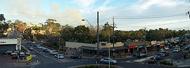
The Yarra Ranges Shire is a Local Government Area in Victoria
, Australia
, located in the outer eastern and northeastern suburbs of Melbourne
extending into the Yarra Valley
and Dandenong Ranges
. It has an area of 2469.9 square kilometres (953.6 sq mi), and at the 2006 census, it had a population of 140,217.
It was formed in 1994 by the merger of parts of the Shire of Sherbrooke
, Shire of Lillydale
, Shire of Healesville
and Shire of Upper Yarra
.
 Suburbs and towns within the boundaries of the Shire include:
Victoria (Australia)
Victoria is the second most populous state in Australia. Geographically the smallest mainland state, Victoria is bordered by New South Wales, South Australia, and Tasmania on Boundary Islet to the north, west and south respectively....
, Australia
Australia
Australia , officially the Commonwealth of Australia, is a country in the Southern Hemisphere comprising the mainland of the Australian continent, the island of Tasmania, and numerous smaller islands in the Indian and Pacific Oceans. It is the world's sixth-largest country by total area...
, located in the outer eastern and northeastern suburbs of Melbourne
Melbourne
Melbourne is the capital and most populous city in the state of Victoria, and the second most populous city in Australia. The Melbourne City Centre is the hub of the greater metropolitan area and the Census statistical division—of which "Melbourne" is the common name. As of June 2009, the greater...
extending into the Yarra Valley
Yarra Valley
The Yarra Valley is the name given to the region surrounding the Yarra River in Victoria, Australia. The river originates approximately 90 kilometres east of the City of Melbourne and flows towards it and out into Port Phillip Bay...
and Dandenong Ranges
Dandenong Ranges
The Dandenong Ranges are a set of low mountain ranges, rising to 633 metres at Mount Dandenong, approximately 35 km east of Melbourne, Victoria, Australia...
. It has an area of 2469.9 square kilometres (953.6 sq mi), and at the 2006 census, it had a population of 140,217.
It was formed in 1994 by the merger of parts of the Shire of Sherbrooke
Shire of Sherbrooke
The Shire of Sherbrooke was a Local Government Area located about east of Melbourne, the state capital of Victoria, Australia. The shire covered an area of , and existed from 1963 until 1994...
, Shire of Lillydale
Shire of Lillydale
The Shire of Lillydale was a Local Government Area located about northeast of Melbourne, the state capital of Victoria, Australia. The shire covered an area of , and existed from 1856 until 1994....
, Shire of Healesville
Shire of Healesville
The Shire of Healesville was a Local Government Area located about northeast of Melbourne, the state capital of Victoria, Australia. The shire covered an area of , and existed from 1887 until 1994.-History:...
and Shire of Upper Yarra
Shire of Upper Yarra
The Shire of Upper Yarra was a Local Government Area centred on the upper reaches of the Yarra Valley about east of Melbourne, the state capital of Victoria, Australia, and extending eastwards into Victoria's interior. The shire covered an area of , and existed from 1888 until 1994.-History:Upper...
.
Wards
Yarra Ranges is divided into nine wards, each of which elects one councillor for a period of four years.- Billanook Ward
- Chandler Ward, named after a pioneering family
- Chirnside Ward, named after George Chirnside, a MooroolbarkMooroolbark, VictoriaMooroolbark is a suburb of Melbourne, Victoria, Australia, 31 km east from Melbourne's central business district. Its Local Government Area is the Shire of Yarra Ranges. At the 2006 Census, Mooroolbark had a population of 19,335...
settler and owner of the Werribee Park Mansion. - Lyster Ward, named after William LysterWilliam Saurin LysterWilliam Saurin Lyster , was an impresario, active in Australia.Lyster was born in Dublin, the third son of Chaworth Lyster, a captain in the army, and his wife Anne, née Keightly. His uncle was William Saurin, attorney-general for Ireland, and was partly of French extraction...
, an impresario who had a dairy farm in the area. - Melba Ward, named after Dame Nellie MelbaNellie MelbaDame Nellie Melba GBE , born Helen "Nellie" Porter Mitchell, was an Australian operatic soprano. She became one of the most famous singers of the late Victorian Era and the early 20th century...
. - O'Shannassy Ward, named after O'Shannassy River and reservoir, ultimately from John O'ShanassyJohn O'ShanassySir John O'Shanassy, KCMG , Australian colonial politician, was the 2nd Premier of Victoria. O'Shanassy was born near Thurles in County Tipperary, Ireland, the son of a surveyor, and came to the Port Phillip District in 1839...
(sic), premier of Victoria . - Ryrie Ward, named after William Ryrie who planted the first vineyards in the area.
- Streeton Ward, named after Sir Arthur StreetonArthur StreetonSir Arthur Ernest Streeton was an Australian landscape painter.-Early life:Streeton was born in Mount Duneed, near Geelong, and his family moved to Richmond in 1874. In 1882, Streeton commenced art studies with G. F. Folingsby at the National Gallery School.Streeton was influenced by French...
, a painter who lived at OlindaOlinda, VictoriaOlinda is a suburb in Melbourne, Victoria, Australia, 36 km east from Melbourne's central business district. Its Local Government Area is the Shire of Yarra Ranges. At the 2006 Census, Olinda had a population of 1568.-History:...
. - Walling Ward, named after Edna WallingEdna WallingEdna Walling was one of Australia's most influential landscape designers.Walling grew up in the village of Bickleigh in Devon, England...
, landscape designer.
Suburbs and towns
Suburbs
|
Hills Townships
Ferny Creek, Victoria Ferny Creek is a suburb in Melbourne, Victoria, Australia, 33 km south-east of Melbourne's central business district. Its Local Government Area is the Shire of Yarra Ranges. At the 2006 Census, Ferny Creek had a population of 1536.... Kallista, Victoria Kallista is a locality within Greater Melbourne beyond the Melbourne metropolitan area Urban Growth Boundary, 36 km south-east from Melbourne's central business district. Its Local Government Area is the Shire of Yarra Ranges... Kalorama, Victoria Kalorama is a suburb in Melbourne, Victoria, Australia, 35 km east from Melbourne's central business district. Its Local Government Area is the Shire of Yarra Ranges. At the 2006 Census, Kalorama had a population of 1,157.... Macclesfield, Victoria Macclesfield is a town in Victoria, Australia, 47 km east from Melbourne's central business district. Its Local Government Area is the Shire of Yarra Ranges. At the 2006 Census, Macclesfield had a population of 1,041.... Menzies Creek, Victoria Menzies Creek is a suburb in Melbourne, Victoria, Australia, 42 km south-east from Melbourne's central business district. Its Local Government Area is the Shire of Yarra Ranges... Monbulk, Victoria Monbulk is a satellite town & suburb of Melbourne located 42 km east from Melbourne's central business district. Its Local Government Area is the Shire of Yarra Ranges. At the 2006 Census, Monbulk had a population of 2715.-History:... Mount Dandenong, Victoria Mount Dandenong is both a mountain and small township/suburb of Greater Melbourne, Victoria, Australia, 35 km east from Melbourne's central business district. Its Local Government Area is the Shire of Yarra Ranges... Olinda, Victoria Olinda is a suburb in Melbourne, Victoria, Australia, 36 km east from Melbourne's central business district. Its Local Government Area is the Shire of Yarra Ranges. At the 2006 Census, Olinda had a population of 1568.-History:... Sassafras, Victoria Sassafras is a locality and township within Greater Melbourne beyond the Melbourne metropolitan area Urban Growth Boundary, 43 km east from Melbourne's central business district. Its Local Government Area is the Shire of Yarra Ranges. At the 2006 Census, Sassafras had a population of 968... Selby, Victoria Selby is a suburb in Melbourne, Victoria, Australia, 37 km south-east from Melbourne's central business district. Its Local Government Area is the Shire of Yarra Ranges... Sherbrooke, Victoria Sherbrooke is a settlement in Victoria, Australia, 35 km east of Melbourne. Its local-government area is the Shire of Yarra Ranges. At the 2006 census, Sherbrooke had a population of 196.... Silvan, Victoria Silvan is a town in Victoria, Australia, 40 km east from Melbourne's central business district. Its Local Government Area is the Shire of Yarra Ranges... The Patch, Victoria The Patch is a suburb in Melbourne, Victoria, Australia, 39 km east from Melbourne's central business district. Its Local Government Area is the Shire of Yarra Ranges. At the 2006 Census, The Patch had a population of 793.-History:... Tremont, Victoria Tremont is a suburb in Melbourne, Victoria, Australia, 31 km south-east from Melbourne's central business district. Its Local Government Area is the Shire of Yarra Ranges... |
Rural Localities (North East)
Badger Creek, Victoria Badger Creek is a town in Victoria, Australia, 53 km north-east from Melbourne's central business district. Its Local Government Area is the Shire of Yarra Ranges... Chum Creek, Victoria Chum Creek is a town in Victoria, Australia, 50 km north-east from Melbourne's central business district. Its Local Government Area is the Shire of Yarra Ranges. At the 2006 Census, Chum Creek had a population of 848.... Coldstream, Victoria Coldstream is a locality and township within Greater Melbourne beyond the Melbourne metropolitan area Urban Growth Boundary, 36 km north-east from Melbourne's central business district. Its Local Government Area is the Shire of Yarra Ranges... Dixons Creek, Victoria Dixons Creek is a town in Victoria, Australia, 46 km north-east from Melbourne's central business district. Its Local Government Area is the Shire of Yarra Ranges. At the 2006 Census, Dixons Creek had a population of 596.... Gruyere, Victoria Gruyere is a town in Victoria, Australia, 43 km north-east from Melbourne's central business district. Its Local Government Area is the Shire of Yarra Ranges. At the 2006 Census, Gruyere had a population of 696.... Healesville, Victoria Healesville is a town in Victoria, Australia, 52 km north-east from Melbourne's central business district. Its Local Government Area is the Shire of Yarra Ranges... Tarrawarra, Victoria Tarrawarra is a town in Victoria, Australia, 45 km north-east from Melbourne's central business district. Its Local Government Area is the Shire of Yarra Ranges.... Yarra Glen, Victoria Yarra Glen is a town in Victoria, Australia, 40 km north-east from Melbourne's central business district. Its Local Government Area is the Shire of Yarra Ranges... Yering, Victoria Yering is a town in Victoria, Australia, 38 km north-east from Melbourne's central business district. Its Local Government Area is the Shire of Yarra Ranges.Yering was home to one of Victoria's first wineries.-History:... |
Rural Localities (East)
Don Valley, Victoria Don Valley is a town in Victoria, Australia, approximately 70 km east of Melbourne's central business district. Its Local Government Area is the Shire of Yarra Ranges... Hoddles Creek, Victoria Hoddles Creek is a bounded rural locality in Victoria, Australia, 72 km east from Melbourne's central business district. Its Local Government Area is the Shire of Yarra Ranges. At the 2006 census, Hoddles Creek had a population of 1,061. It is situated on the banks of Hoddle's Creek, which is, in... Launching Place, Victoria Launching Place is a town in Victoria, Australia, 54 km east from Melbourne's central business district. Its Local Government Area is the Shire of Yarra Ranges... Millgrove, Victoria Millgrove is a town in Victoria, Australia, 63 km east from Melbourne's central business district. Its Local Government Area is the Shire of Yarra Ranges... Powelltown, Victoria Powelltown is a town in Victoria, Australia, 70 km east from Melbourne's central business district. Its Local Government Area is the Shire of Yarra Ranges. At the 2006 Census, Powelltown had a population of 201.... Seville, Victoria Seville is a suburb to the east of Melbourne, the capital city of Victoria, Australia, along Warburton Highway. Its Local Government Area is the Shire of Yarra Ranges and sits within the Yarra Valley wine region. It is serviced by Metlink bus 683 from Chirnside Park to Warburton via Lilydale... Seville East, Victoria Seville East is a town in Victoria, Australia, 46 km north-east from Melbourne's central business district. Its Local Government Area is the Shire of Yarra Ranges. At the 2006 Census, Seville East had a population of 621.... Wandin East, Victoria Wandin East is a town in Victoria, Australia, 45 km east from Melbourne's central business district. Its Local Government Area is the Shire of Yarra Ranges... Wandin North, Victoria Wandin North is a suburb in Melbourne, Victoria, Australia, 40 km north-east from Melbourne's central business district. Its Local Government Area is the Shire of Yarra Ranges. At the 2006 Census, Wandin North had a population of 1655.-History:... Warburton, Victoria Warburton is a town in Victoria, Australia, 72 km east from Melbourne's central business district. Its Local Government Area is the Shire of Yarra Ranges. At the 2006 Census, Warburton had a population of 2288.... Warburton East, Victoria Warburton East is a town in Victoria, Australia, 67 km east from Melbourne's central business district. Its Local Government Area is the Shire of Yarra Ranges. At the 2006 Census, Warburton East had a population of 721.... Wesburn, Victoria Wesburn is a town in Victoria, Australia, 62 km east from Melbourne's central business district. Its Local Government Area is the Shire of Yarra Ranges. At the 2006 Census, Wesburn had a population of 619... Woori Yallock, Victoria Woori Yallock is a town in Victoria, Australia, 56 km east of Melbourne's central business district. Its Local Government Area is the Shire of Yarra Ranges... Yarra Junction, Victoria Yarra Junction is a town in Victoria, Australia, east from Melbourne's central business district. It sits at the junction of the Yarra and Little Yarra Rivers. Its Local Government Area is the Shire of Yarra Ranges... Yellingbo, Victoria Yellingbo is a town in Victoria, Australia, 48 km east from Melbourne's central business district. Its Local Government Area is the Shire of Yarra Ranges... |
Major Thoroughfares
- Burwood HighwayBurwood HighwayBurwood Highway is a major transportation link with Melbourne's eastern suburbs. It begins in the suburb of Kooyong, Melbourne at the junction of the Monash Freeway as Toorak Road between Monash Freeway and Warrigal Road, and finishes in Belgrave, Victoria in the Dandenong Ranges...

- Canterbury Road/Swansea Road

- Maroondah HighwayMaroondah HighwayMaroondah Highway , is a major east-west thoroughfare in the eastern suburbs of Melbourne and a highway servicing the lower alpine region Victoria, Australia.-History:...


- Belgrave-Hallam Road/Monbulk Road/Hereford Road/Anderson Street

- Belgrave Road
- Olinda-Monbulk Road/Emerald Monbulk Road
- Warburton HighwayWarburton HighwayWarburton Highway is a 35 kilometre west-east highway starting on the eastern fringes of Melbourne, Victoria at the Maroondah Highway just after Lilydale, connecting Melbourne to the Yarra Valley wine region and its towns. The entire road is within the Shire of Yarra Ranges local government area...

- Healesville- Koo Wee Rup Road

- Mount Dandenong (Tourist) Road
