
Shire of Wandering
Encyclopedia
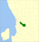
The Shire of Wandering is a Local Government Area
in the Wheatbelt region of Western Australia
, and, with a population of 318 as at the 2001 census, is one of the nation's smallest. It covers an area of 1901 square kilometres (734 sq mi) generally to the east of Albany Highway
about 120 kilometres (75 mi) south-east of Perth
, the state capital. The Shire's seat of government is the town of Wandering
.
. On 1 July 1961, it became a Shire following the enactment of the Local Government Act 1960.
From 1941 until the 2009 elections, it was divided into four wards as follows:
Local Government Areas of Western Australia
The Australian state of Western Australia is divided into 141 local government areas...
in the Wheatbelt region of Western Australia
Western Australia
Western Australia is a state of Australia, occupying the entire western third of the Australian continent. It is bounded by the Indian Ocean to the north and west, the Great Australian Bight and Indian Ocean to the south, the Northern Territory to the north-east and South Australia to the south-east...
, and, with a population of 318 as at the 2001 census, is one of the nation's smallest. It covers an area of 1901 square kilometres (734 sq mi) generally to the east of Albany Highway
Albany Highway
Albany Highway is a generally northwest-southeast highway in the south of Western Australia which links the state's capital Perth with its oldest settlement, Albany. The highway is approximately in length, is designated State Route 30 and separates Western Australia's Great Southern region from...
about 120 kilometres (75 mi) south-east of Perth
Perth, Western Australia
Perth is the capital and largest city of the Australian state of Western Australia and the fourth most populous city in Australia. The Perth metropolitan area has an estimated population of almost 1,700,000....
, the state capital. The Shire's seat of government is the town of Wandering
Wandering, Western Australia
Wandering is a town located in the Wheatbelt region of Western Australia, approximately from the state capital, Perth, just off the Albany Highway. It is the main town in the Shire of Wandering...
.
History
The Wandering Road District was gazetted on 6 October 1874 out of land previously managed by the Williams Road BoardShire of Williams
The Shire of Williams is a Local Government Area in the Wheatbelt region of Western Australia, about southeast of the state capital, Perth. The Shire covers an area of , and its seat of government is the town of Williams.-History:...
. On 1 July 1961, it became a Shire following the enactment of the Local Government Act 1960.
Wards
The shire is undivided and is represented by 7 councillors.From 1941 until the 2009 elections, it was divided into four wards as follows:
- North Ward (2 councillors)
- North East Ward (2 councillors)
- South Ward (2 councillors)
- Town Ward (1 councillor)
Towns and localities
- WanderingWandering, Western AustraliaWandering is a town located in the Wheatbelt region of Western Australia, approximately from the state capital, Perth, just off the Albany Highway. It is the main town in the Shire of Wandering...
- Bannister
- Codjatotine
- DwardaDwarda, Western AustraliaDwarda is a small town located in the Wheatbelt region of Western Australia, south of the town of Wandering on the Hotham River.-History:The name is a contraction of nearby Dwardadine Creek, with "dwarda" being an Noongar Aboriginal name for the dingo...
- North BannisterNorth Bannister, Western AustraliaNorth Bannister is a small town located in the Wheatbelt region of Western Australia, south-southeast of the state capital, Perth along Albany Highway between Armadale and Williams....
- Pumphreys Bridge
Population
| Year | Population |
|---|---|
| 1911 | 441 |
| 1921 | 564 |
| 1933 | 450 |
| 1947 | 419 |
| 1954 | 557 |
| 1961 | 661 |
| 1966 | 611 |
| 1971 | 500 |
| 1976 | 470 |
| 1981 | 487 |
| 1986 | 402 |
| 1991 | 414 |
| 1996 | 370 |
| 2001 | 318 |
| 2006 | 355 |