
Shire of Quairading
Encyclopedia
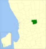
The Shire of Quairading is a Local Government Area
in the Wheatbelt region of Western Australia
, about 170 kilometres (106 mi) east of the state capital, Perth
. The Shire covers an area of 2018 square kilometres (779 sq mi), and its seat of government is the town of Quairading
.
. In 1913, Greenhills was broken up to form Avon, East Avon (Bruce Rock
) and Kunjinn (Corrigin
). In 1922 the Avon Road District was renamed to Quairading, and on 1 July 1961, it became a Shire under the Local Government Act 1960.
Local Government Areas of Western Australia
The Australian state of Western Australia is divided into 141 local government areas...
in the Wheatbelt region of Western Australia
Western Australia
Western Australia is a state of Australia, occupying the entire western third of the Australian continent. It is bounded by the Indian Ocean to the north and west, the Great Australian Bight and Indian Ocean to the south, the Northern Territory to the north-east and South Australia to the south-east...
, about 170 kilometres (106 mi) east of the state capital, Perth
Perth, Western Australia
Perth is the capital and largest city of the Australian state of Western Australia and the fourth most populous city in Australia. The Perth metropolitan area has an estimated population of almost 1,700,000....
. The Shire covers an area of 2018 square kilometres (779 sq mi), and its seat of government is the town of Quairading
Quairading, Western Australia
Quairading is a Western Australian town located in the Wheatbelt region. It is the seat of government for the Shire of Quairading.-History:The town was named for Quairading Spring, derived from a local Aboriginal word recorded in 1872 by surveyor Alexander Forrest. The first European settler in the...
.
History
Quairading was initially constituted as the Greenhills Road District in 1892, covering a large area east of YorkYork, Western Australia
York is the oldest inland town in Western Australia, situated 97 km east of Perth in the Avon Valley near Northam, and is the seat of the Shire of York...
. In 1913, Greenhills was broken up to form Avon, East Avon (Bruce Rock
Shire of Bruce Rock
The Shire of Bruce Rock is a Local Government Area in the Wheatbelt region of Western Australia, about south of Merredin and about east of the state capital, Perth. The Shire covers an area of , and its seat of government is the town of Bruce Rock.-History:...
) and Kunjinn (Corrigin
Shire of Corrigin
The Shire of Corrigin is a Local Government Area located in the Wheatbelt region of Western Australia, about east of the state capital, Perth. Its seat of government is the town of Corrigin...
). In 1922 the Avon Road District was renamed to Quairading, and on 1 July 1961, it became a Shire under the Local Government Act 1960.
Wards
The shire is no longer divided into wards and the 9 councillors sit at large. Prior to the 2003 elections, there were 11 councillors representing five wards: Town (3), Southwest, Southeast, Northwest and Northeast (2 each).Towns and localities
- QuairadingQuairading, Western AustraliaQuairading is a Western Australian town located in the Wheatbelt region. It is the seat of government for the Shire of Quairading.-History:The town was named for Quairading Spring, derived from a local Aboriginal word recorded in 1872 by surveyor Alexander Forrest. The first European settler in the...
- BadjalingBadjaling, Western AustraliaBadjaling is a small town in the Wheatbelt region of Western Australia located close to the Salt River.The townsite was originally declared as Yuruga in 1914 but the name was changed to Badjaling later the same year....
- BalkulingBalkuling, Western AustraliaBalkuling is an abandoned town 192 km east of Perth, Western Australia along the Quairading –York Road situated in the Wheatbelt Region of Western Australia....
- DanginDangin, Western AustraliaDangin is a small town in the wheatbelt region of Western Australia. It is located about 7 kilometres south-west of Quairading, in the Shire of Quairading...
- Doodenanning
- PantapinPantapin, Western AustraliaPantapin in a small town in the Wheatbelt region of Western Australia.The town originated as a railway siding that was planned in 1912 as part of the Quairading to Bruce Rock line....
- YotingYoting, Western AustraliaYoting is a small town located between Quairadingand Bruce Rock in the Wheatbelt Region of Western Australia.Originating as a station on the Quairading to Bruce Rock railway line when it was established in 1912. Lots were surveyed in early 1914 and the townsite was gazetted later the same year.The...
- Wamenusking
- South Caroling
Population
| Year | Population |
|---|---|
| 1921 | 1,273 |
| 1933 | 1,754 |
| 1947 | 1,424 |
| 1954 | 1,721 |
| 1961 | 1,789 |
| 1966 | 1,687 |
| 1971 | 1,652 |
| 1976 | 1,470 |
| 1981 | 1,300 |
| 1986 | 1,243 |
| 1991 | 1,147 |
| 1996 | 1,173 |
| 2001 | 1,041 |
| 2006 | 1,022 |