
Shire of Corrigin
Encyclopedia
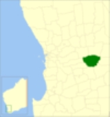
The Shire of Corrigin is a Local Government Area located in the Wheatbelt region of Western Australia
, about 230 kilometres (143 mi) east of the state capital, Perth
. Its seat of government is the town of Corrigin
. The shire covers an area of 3095 square kilometres (1,195 sq mi) and the economy, worth approximately $50 million per year to the state economy, is based on agriculture - predominantly cereal grains and sheep, with some supporting industries including a flour mill.
), Greenhills and Brookton
Road Boards. In 1913, after the announcement of a proposed railway from Brookton
on the Great Southern Railway
to terminate in the town of Kunjin, the Kunjinn Road Board was gazetted. The first Board members held their meetings in a small timber and iron building with their first ever purchase being a billy, tea and sugar. After only three meetings, it was decided to shift the meeting venue to the new townsite of Corrigin
as Kunjin was no longer under consideration as the major rail junction. Accordingly, in 1914, the district was renamed Corrigin. On 1 July 1961, it became a Shire following enactment of the Local Government Act 1960.
From 1 May 1999 until 19 October 2007, the shire was divided into 3 wards, each of 3 councillors:
As of 20 October 2007, the council is undivided and all 9 councillors represent the entire shire.
Western Australia
Western Australia is a state of Australia, occupying the entire western third of the Australian continent. It is bounded by the Indian Ocean to the north and west, the Great Australian Bight and Indian Ocean to the south, the Northern Territory to the north-east and South Australia to the south-east...
, about 230 kilometres (143 mi) east of the state capital, Perth
Perth, Western Australia
Perth is the capital and largest city of the Australian state of Western Australia and the fourth most populous city in Australia. The Perth metropolitan area has an estimated population of almost 1,700,000....
. Its seat of government is the town of Corrigin
Corrigin, Western Australia
Corrigin is a town located in the central Wheatbelt region of Western Australia, east-southeast of the state capital, Perth, Western Australia, along State Route 40...
. The shire covers an area of 3095 square kilometres (1,195 sq mi) and the economy, worth approximately $50 million per year to the state economy, is based on agriculture - predominantly cereal grains and sheep, with some supporting industries including a flour mill.
History
From 1891 until 1913, different parts of the area was managed by Morambine (PingellyShire of Pingelly
The Shire of Pingelly is a Local Government Area in the Wheatbelt region of Western Australia, about southeast of the state capital, Perth, between the Shires of Brookton and Cuballing along the Great Southern Highway. The Shire covers an area of , and its seat of government is the town of...
), Greenhills and Brookton
Shire of Brookton
The Shire of Brookton is a Local Government Area located in the Wheatbelt region of Western Australia, about southeast of Perth, the state capital...
Road Boards. In 1913, after the announcement of a proposed railway from Brookton
Brookton, Western Australia
Brookton is a town located in the Wheatbelt region of Western Australia, Australia, from the state capital, Perth via the Brookton Highway where it crosses the Great Southern Highway. The town is also located on the Great Southern railway line. It is located within, and is the seat of government...
on the Great Southern Railway
Great Southern Railway (Western Australia)
The Great Southern Railway was the name of a railway company that operated from Beverley to Albany in Western Australia between 1886 and 1896. In 1896 the Western Australian Government Railways took over this company and the railway route also kept the name.- Construction :The first sods for the...
to terminate in the town of Kunjin, the Kunjinn Road Board was gazetted. The first Board members held their meetings in a small timber and iron building with their first ever purchase being a billy, tea and sugar. After only three meetings, it was decided to shift the meeting venue to the new townsite of Corrigin
Corrigin, Western Australia
Corrigin is a town located in the central Wheatbelt region of Western Australia, east-southeast of the state capital, Perth, Western Australia, along State Route 40...
as Kunjin was no longer under consideration as the major rail junction. Accordingly, in 1914, the district was renamed Corrigin. On 1 July 1961, it became a Shire following enactment of the Local Government Act 1960.
Wards
The first ward system, established in 1914, divided the road district into the Wogerlin, Kurren-Kutten, Bullaring, Central, Dondakin and Kunjinn Wards. The first two of these were abolished in 1988 and replaced with the Bilbarin Ward, and the Central Ward gradually increased in importance, reaching a peak of 5 of the 11 councillors then in place between 1992 and 1999.From 1 May 1999 until 19 October 2007, the shire was divided into 3 wards, each of 3 councillors:
- North Ward
- Central Ward
- South Ward
As of 20 October 2007, the council is undivided and all 9 councillors represent the entire shire.
Towns and localities
- CorriginCorrigin, Western AustraliaCorrigin is a town located in the central Wheatbelt region of Western Australia, east-southeast of the state capital, Perth, Western Australia, along State Route 40...
- BilbarinBilbarin, Western AustraliaBilbarin is a small town in the Wheatbelt region of Western Australia.The townsite is located along the railway line between Corrigin and Bruce Rock....
- BullaringBullaring, Western AustraliaBullaring is a small town located in the Wheatbelt region of Western Australia.The townsite was gazetted in 1914 and is situated along the railway line between Corrigin and Wickepin....
- Bulyee
- Jubuk
- Kunjin
Population
| Year | Population |
|---|---|
| 1921 | 1,286 |
| 1933 | 1,845 |
| 1947 | 1,445 |
| 1954 | 1,894 |
| 1961 | 2,123 |
| 1966 | 2,099 |
| 1971 | 1,766 |
| 1976 | 1,736 |
| 1981 | 1,620 |
| 1986 | 1,450 |
| 1991 | 1,384 |
| 1996 | 1,276 |
| 2001 | 1,227 |
| 2006 | 1,145 |