
Shire of Narembeen
Encyclopedia
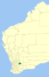
The Shire of Narembeen is a Local Government Area
in the Eastern Wheatbelt region of Western Australia
, about 300 kilometres (186 mi) east of the state capital, Perth
, and between the shires of Merredin
to the north, and Kondinin
to the south. The Shire has a land area of 3833 square kilometres (1,480 sq mi) and its seat of government is the town of Narembeen
.
Local Government Areas of Western Australia
The Australian state of Western Australia is divided into 141 local government areas...
in the Eastern Wheatbelt region of Western Australia
Western Australia
Western Australia is a state of Australia, occupying the entire western third of the Australian continent. It is bounded by the Indian Ocean to the north and west, the Great Australian Bight and Indian Ocean to the south, the Northern Territory to the north-east and South Australia to the south-east...
, about 300 kilometres (186 mi) east of the state capital, Perth
Perth, Western Australia
Perth is the capital and largest city of the Australian state of Western Australia and the fourth most populous city in Australia. The Perth metropolitan area has an estimated population of almost 1,700,000....
, and between the shires of Merredin
Shire of Merredin
The Shire of Merredin is a Local Government Area in the Wheatbelt region of Western Australia, about east of Perth, the state capital. Its seat of government is the town of Merredin, where 2,804 of the Shire's 3,595 residents live. The Shire covers an area of .-History:On 30 June 1921, the...
to the north, and Kondinin
Shire of Kondinin
The Shire of Kondinin is a Local Government Area in the Eastern Wheatbelt region of Western Australia, about east of the state capital, Perth. The Shire's land area of forms a narrow east-west band, located between the Shire of Narembeen to the north and the Shire of Kulin to the south...
to the south. The Shire has a land area of 3833 square kilometres (1,480 sq mi) and its seat of government is the town of Narembeen
Narembeen, Western Australia
Narembeen is a town in the Western Australia wheatbelt. It is 286 km, almost due east, from Perth, the capital of WA. It is the major settlement in the Shire of Narembeen, in which the major industries are growing cereal crops and raising cattle and sheep....
.
History
In 1924, the Narembeen Road Board was gazetted and on 1 July 1961, it became a Shire Council following changes to the Local Government Act.Wards
The shire has been divided into 2 wards.- Rural Ward (5 councillors)
- Town Ward (4 councillors)
Towns and localities
- NarembeenNarembeen, Western AustraliaNarembeen is a town in the Western Australia wheatbelt. It is 286 km, almost due east, from Perth, the capital of WA. It is the major settlement in the Shire of Narembeen, in which the major industries are growing cereal crops and raising cattle and sheep....
- Cramphorne
- Emu Hill
- Mount Walker
- South KummininSouth Kumminin, Western AustraliaSouth Kumminin in a small town in the Wheatbelt region of Western Australia.The name is Indigenous Australian in origin but its meaning is unknown....
- Wogarl